Kenai Peninsula
| Kenai Peninsula | ||
 The Kenai Peninsula south of the Turnagain Arm |
||
| Geographical location | ||
|
|
||
| Coordinates | 60 ° 20 ′ 0 ″ N , 150 ° 30 ′ 0 ″ W | |
| Waters 1 | Cook Inlet , Turnagain Arm | |
| Waters 2 | Gulf of Alaska ( Pacific Ocean ) | |
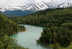
 The Kenai River in front of the Kenai Mountains |
||
The Kenai Peninsula ( English Kenai Peninsula ) is a peninsula in Alaska ( USA ) south of Anchorage .
geography
To the north are the Chugach Mountains , which separates the bay of the Turnagain Arm from the peninsula, and to the west is the average 30 km wide Cook Inlet , a bay of the Gulf of Alaska with the volcanoes of the Alaska range on the opposite side. To the east lies Prince William Sound and the South finally the Pacific Ocean . Kenai is connected to the mainland by the isthmus at Portage Glacier .
In the eastern part of the Kenai Peninsula lie the Kenai Mountains , which are home to three ice caps, with the Harding Icefield being North America's second largest. In the southeast is the Kenai Fjords National Park , in the northeast the Chugach National Forest . The western part is characterized by a low plain, in the southeast rather hilly, in the northeast by a lake plateau formed by prehistoric glaciers. The Kenai National Wildlife Refuge and Kachemak State Park make up a large portion of western Kenai. The landscape consists largely of mixed forests .
Alaska's only scenic highway , the Seward Highway , runs from Anchorage, along the Turnagain Arm , then through the Kenai Mountains to Seward , the entrance to Kenai Fjords National Park. At Tern Lake in the mountains, the Sterling Highway branches off to the west, along the Kenai River , past Kenai Lake and Skilak Lake , and finally to the south, along Cook Inlet and Tustumena Lake , Alaska's fourth largest lake.
places
Places with around 3000 to 6000 inhabitants are Seward in the east, Kenai and Soldotna in the west and Homer in the southwest. Smaller settlements are u. a. Hope , Moose Pass , Cooper Landing , Sterling , Nikiski , Kasilof , Ninilchik , Anchor Point and Nikolaevsk .
history
The Kenai Peninsula was originally inhabited by the Dena'ina Indians, a tribe of the Athabascans . Russian fur traders first settled here at the end of the 18th century (for a critical view, see also Russian America ).
Economy, tourism
Tourism and the oil industry are among the main sources of income on the peninsula. Because of its varied landscapes - mountains, glaciers, lakes, rivers, beaches - the Kenai attracts thousands of tourists from all over the world every year, who come here to relax and to fish for salmon and halibut.
Visitors are likely to see moose . Many black and brown bears ( grizzly ) also live on the Kenai Peninsula. The confluence of the Russian River and Kenai River is a magnet for fly anglers , who fish thousands of sockeye salmon here shoulder to shoulder every year . A world record in sport fishing for king salmon was set near the mouth of the Kenai River in Cook Inlet in 1985 (97 pounds, ≈ 44 kg). You can dig for razor clams on the beach near Clam Gulch .


