Skilak Lake
| Skilak Lake | ||
|---|---|---|

|
||
| The Kenai River flows into the lake | ||
| Geographical location | Kenai Peninsula in Alaska ( USA ) | |
| Tributaries | Kenai River , Skilak River | |
| Drain | Kenai River | |
| Islands | Frying Pan Island, Caribou Island, Lucas Island | |
| Location close to the shore | sterling | |
| Data | ||
| Coordinates | 60 ° 25 ′ N , 150 ° 19 ′ W | |
|
|
||
| Altitude above sea level | 59 m | |
| surface | 98 km² | |
| length | 23 km | |
| width | 6.4 km | |
| Maximum depth | 161 m | |
|
particularities |
frozen over from late November to late April |
|

|
||
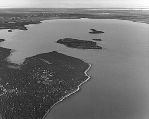
| Aerial view with Caribou Island | ||
The Skilak Lake is a 98 km² large lake on the Kenai Peninsula in Alaska .
The 23 km long and maximum 6.4 km wide lake of glacial origin is located at an altitude of 59 m in the western foothills of the Kenai Mountains in the Kenai National Wildlife Refuge . The Kenai River flows through Skilak Lake from the east. The Sterling Highway runs north . Meltwater from the Skilak Glacier, fed by the Harding Icefield , flows over the Skilak River to the eastern end of the lake .
Web links
Commons : Skilak Lake - collection of images, videos and audio files
Individual evidence
View from Sterling Highway of Skilak Lake and the Kenai Mountains

