Alaska Peninsula
| Alaska Peninsula | ||
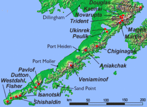
 Alaska peninsula with some volcanoes |
||
| Geographical location | ||
|
|
||
| Coordinates | 57 ° N , 159 ° W | |
| Waters 1 | Bristol Bay ( Bering Sea ) | |
| Waters 2 | Pacific Ocean | |
| length | 800 km | |
The Alaska Peninsula ( English Alaska Peninsula ) is part of the mainland of Alaska ( USA ) an elongated peninsula , to whose western extension the Aleutians join.
Between the Bristol Bay , a part of the Bering Sea , the north and the actual North Pacific in the south it extends to about 800 km in length towards the west, and along the entire length of the Alaska Peninsula - as on the Aleutian Range - numerous volcanoes the Determine the landscape. Hundreds of small islands and islets are in front of the peninsula .
Located on the peninsula are Katmai National Park and Preserve , Aniakchak National Monument and Preserve , Becharof National Wildlife Refuge , Alaska Peninsula National Wildlife Refuge, and Izembek National Wildlife Refuge .
literature
- Rennick, Penny: Alaska Peninsula (Alaska Geographic, Vol 21, No 1) . Alaska Geographic Society, 1994, ISBN 1-56661-018-4 (English).
Web links
Commons : Alaska Peninsula - Collection of Pictures, Videos, and Audio Files
