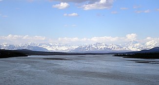
Susitna River
| Susitna River | ||
|
View from Denali Highway on the Susitna River |
||
| Data | ||
| Water code | US : 1416406 | |
| location | Alaska ( USA ) | |
| River system | Susitna River | |
| Drain over | Susitna River → Cook Inlet → Pacific Ocean | |
| origin |
Susitna Glacier 63 ° 26 ′ 10 ″ N , 147 ° 11 ′ 55 ″ W |
|
| Source height | 1026 m | |
| muzzle |
Cook Inlet Coordinates: 61 ° 16 ′ 14 " N , 150 ° 34 ′ 33" W 61 ° 16 ′ 14 " N , 150 ° 34 ′ 33" W. |
|
| Mouth height | 0 m | |
| Height difference | 1026 m | |
| Bottom slope | 2 ‰ | |
| length | 503 km | |
| Catchment area | 52,000 km² | |
| Outflow at the level at the mouth |
MQ |
1400 m³ / s |
| Left tributaries | East Fork Susitna River, Maclaren River , Tyone River , Oshetna River , Talkeetna River | |
| Right tributaries | West Fork Susitna River, Chulitna River , Deshka River , Yentna River | |
| Communities | Talkeetna , Susitna | |
|
Location of the Susitna River |
||
| West Fork Susitna River | ||
| Water code | US : 1411891 | |
| origin |
West Fork Glacier 63 ° 23 ′ 48 ″ N , 147 ° 32 ′ 39 ″ W |
|
| Source height | approx. 850 m | |
| muzzle | Susitna River 63 ° 13 ′ 20 " N , 147 ° 28 ′ 32" W. |
|
| Mouth height | 757 m | |
| Height difference | approx. 93 m | |
| Bottom slope | approx. 4.4 ‰ | |
| length | 21 km | |
| East Fork Susitna River | ||
| Water code | US : 1401611 | |
| origin | nameless glacier on the southern flank of the Alaska range 63 ° 23 ′ 46 ″ N , 146 ° 51 ′ 10 ″ W |
|
| Source height | approx. 920 m | |
| muzzle | Susitna River 63 ° 19 ′ 35 " N , 147 ° 16 ′ 51" W. |
|
| Mouth height | 776 m | |
| Height difference | approx. 144 m | |
| Bottom slope | approx. 5.8 ‰ | |
| length | 25 km | |
The Susitna River [ su'sɪtnə ] is a 503 km long tributary of the Cook Inlet in the south of the US state Alaska .
The river has its source at the Susitna Glacier on Mount Hayes ( 4216 m ) in the Alaska range and flows along the west side of the Talkeetna Mountains . At Trapper Creek the rivers Chulitna River and Talkeetna River flow into the Susitna, which is navigable from there. Eight kilometers north of Susitna the Yentna River flows into the Susitna River. About 40 km west of Anchorage , the Susitna River finally flows into the Cook Inlet.
Together with the Matanuska River , the Susitna River gives its name to the Matanuska-Susitna Borough and the Matanuska-Susitna Valley ( English Matanuska-Susitna Valley , or Mat-Su for short ) north of Anchorage , one of the most densely populated regions of Alaska.
The West Fork Susitna River is fed by the West Fork Glacier . It flows 21 km in a south-southeast direction and flows into the Susitna River about 30 km below the Susitna Glacier.
The East Fork Susitna River is fed by an unnamed glacier on the southern flank of the Alaska range. It flows 25 km initially in a westerly direction, later in a south-westerly direction and flows into the Susitna River just above the confluence of the West Fork Susitna River.
Web links
Individual evidence
- ↑ Susitna Glacier in the Geographic Names Information System of the United States Geological Survey
- ↑ a b c d USGS - Water Fact Sheet - Largest Rivers in the United States (PDF file; 648 kB)
- ^ West Fork Susitna River in the Geographic Names Information System of the United States Geological Survey
- ^ East Fork Susitna River in the Geographic Names Information System of the United States Geological Survey

