Stikine River
| Stikine River | ||
|
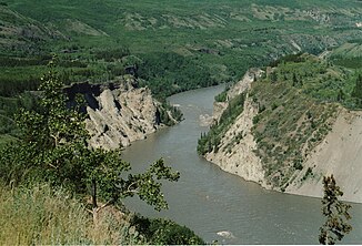
Grand Canyon of the Stikine River near Telegraph Creek |
||
| Data | ||
| Water code | US : 1416405 | |
| location |
British Columbia ( Canada ), Alaska ( USA ) |
|
| River system | Stikine River | |
| source | on the Spatsizi plateau 57 ° 13 ′ 37 ″ N , 128 ° 17 ′ 41 ″ W |
|
| Source height | approx. 1800 m | |
| muzzle | north of Wrangell Island in the Pacific Ocean Coordinates: 56 ° 33 ′ 50 " N , 132 ° 24 ′ 16" W 56 ° 33 ′ 50 " N , 132 ° 24 ′ 16" W |
|
| Mouth height | 0 m | |
| Height difference | approx. 1800 m | |
| Bottom slope | approx. 3 ‰ | |
| length | 600 km | |
| Catchment area | 52,000 km² | |
| Discharge at the gauge near Wrangell A Eo : 50,900 km² |
MQ 1984/2011 Mq 1984/2011 |
1580 m³ / s 31 l / (s km²) |
| Left tributaries | Spatsizi River , Klappan River , Porcupine River , Iskut River , Scud River , Mess Creek , Klastline River | |
| Right tributaries | Tanzilla River , Tuya River , Chutine River , Tahltan River , McBride River , Pitman River , Chukachida River | |
| Communities | Telegraph Creek | |
|
Course of the Stikine River |
||
|
Stikine River in the estuary |
||
The Stikine River [ stɪˈkiːn ] is a river in northwest British Columbia ( Canada ) and in the south of the Alaska Panhandle ( USA ).
geography
The river has its source on the Spatsizi plateau on Mount Umbach at an altitude of about 1800 m . It is 539 km long. It is one of the last natural rivers in North America and drains the equally natural areas east of the Coast Mountains . The Stikine is a fast-flowing mountain river that cuts its way through deep gorges and flows into the Pacific in the Alexander Archipelago , near Wrangell Island . Its catchment area covers around 52,000 km².
The river's name comes from the Tlingit Indians, who call it Shtax 'Héen , which means “cloudy river” (from the semen of the spawning salmon).
The mouth of the river is now in Alaska, but at the time of the border surveys (1901–1903) it was on the border. The lower course of the river today suffers from heavy silting. A state treaty that was supposed to secure the original shipping traffic for mining and trade also allows the Canadian Navy to navigate the Stikine without restriction. Today, however, this right is almost irrelevant, also because the river mouth keeps shifting.
Tributaries
The largest tributaries, classified from source to mouth, are:
history
The Stikine is navigable about 210 km upstream and was used by the Tlingit Indians on the coast as a transport route inland. The first European to discover the river was Samuel Black , who visited the headwaters of the Stikine in 1824 during one of his expeditions. In 1828 Robert Campbell of the Hudson's Bay Company was looking for the last connection on a transcontinental canoe route and therefore researched the Stikine very carefully. In 1879, John Muir traveled the lower third of the river, which reminded him of a 160 km long Yosemite . Muir discovered over 300 glaciers.
Between 1897 and 1898, during the gold rush, the Stikine was the main route into the Klondike area ( Yukon ). Today it forms the main route to the Cassiar mining region in northern British Columbia . The first bridge was built in the 1970s as part of the Stewart-Cassiar Highway . In 1980 a study was started aiming at a dam project, which quickly provoked massive protests. The estuary is a habitat for migratory birds and is now a protected area as part of the Stikine-LeConte Wilderness .
The river is known for its rich salmon bottoms. However, the salmon were severely decimated by commercial fish traps in the early 20th century. Because of this, and because of today's fish traps, the salmon were reduced to a third of the original number.
literature
- Loken, Marty: The Stikine River . Alaska Geographic Society, [Edmonds, Wash.] 1979, ISBN 978-0-88240-133-1 .
Web links
- Stikine River . In: BC Geographical Names (English)
- Stikine River in the United States Geological Survey's Geographic Names Information System
- Stikine River ( English, French ) In: The Canadian Encyclopedia .
- Traffic report in German
- Stikine: The Great River
- National Geographic: Canada's Stikine River Valley
- Stikine River Provincial Park
Individual evidence
- ↑ a b c d USGS - Water Fact Sheet - Largest Rivers in the United States (PDF file; 648 kB)
- ↑ Water Survey of Canada: Station 08CF003 ( Memento of the original from December 24, 2010) Info: The archive link was automatically inserted and has not yet been checked. Please check the original and archive link according to the instructions and then remove this notice.


