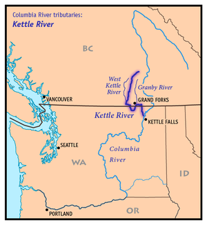
Kettle River (Columbia River)
| Kettle River | ||
| Data | ||
| Water code | US : 1521637 | |
| location |
British Columbia ( Canada ), Washington (USA) |
|
| River system | Columbia River | |
| Drain over | Columbia River → Pacific Ocean | |
| origin |
Holmes Lake 50 ° 6 ′ 55 " N , 118 ° 18 ′ 43" W. |
|
| muzzle |
Franklin D. Roosevelt Lake , Columbia River , Washington Coordinates: 48 ° 40 '22 " N , 118 ° 6' 50" W 48 ° 40 '22 " N , 118 ° 6' 50" W. |
|
| Mouth height |
457 m
|
|
| length | 336 km | |
| Catchment area | 4700 km² | |
| Drain at Laurier Gauge (Washington) |
MNQ MQ MHQ |
2 m³ / s 82 m³ / s 991 m³ / s |
| Left tributaries | Granby River | |
| Right tributaries | West Kettle River | |
| Small towns | Grand Forks | |
|
River basin of the Kettle River |
||
|
Kettle River between Monashee Mountains and Okanagan Plateau |
||
The Kettle River is a 336 km (from end of Holmes Lake to its mouth) long tributary of Columbia in northeast Washington in the United States and southeast British Columbia in Canada . The local Indians called the river Ne-hoi-al-pit-kwu .
course
From its source in British Columbia's Monashee Mountains , the Kettle River flows south to Midway . On its way, many tributaries contribute to the growth of the river, of which the West Kettle River is the most important. Below Midway, the river curves through Ferry County in the United States before returning to Canadian territory. The Granby River flows into Grand Forks . From there, the Kettle River flows another 16 km to the east and then finally leaves Canada on its way south. It flows into the Columbia near Kettle Falls . This is now dammed up at this point by the Grand Coulee Dam to Franklin D. Roosevelt Lake .
Fish species
Originally, salmon and other migratory fish existed in the Kettle River . However, the construction of the Grand Coulee and Chief Joseph dams blocked the migration of fish to the spawning grounds on the upper reaches of the Columbia River and other rivers. During the damming, the former settlement of Kettle Falls sank in the floods of Franklin D. Roosevelt Lake .
Web links
- Kettle River . In: BC Geographical Names (English)
Individual evidence
- ↑ a b c The Atlas of Canada - Rivers
- ↑ Kettle River in the United States Geological Survey's Geographic Names Information System
- ↑ Upper Columbia Subbasin Overview ( Memento of the original from October 2, 2008 in the Internet Archive ) Info: The archive link was automatically inserted and not yet checked. Please check the original and archive link according to the instructions and then remove this notice. , Northwest Power and Conservation Council


