Skagit River
| Skagit River | ||
|
Catchment area and course of the river |
||
| Data | ||
| Water code | US : 1525850 | |
| location |
British Columbia (Canada), Washington (USA) |
|
| River system | Skagit River | |
| Headwaters |
Allison Pass in the Northern Cascade Range 49 ° 7 ′ 23 ″ N , 120 ° 52 ′ 39 ″ W |
|
| Source height | 1366 m | |
| Split into | North Fork and South Fork Skagit River Coordinates: 48 ° 23 '14 " N , 122 ° 22' 1" W 48 ° 23 '14 " N , 122 ° 22' 1" W. |
|
| Mouth height | 3 m | |
| Height difference | 1363 m | |
| Bottom slope | 5.7 ‰ | |
| length | 241 km | |
| Catchment area | 8013 km² | |
| Discharge at the gauge near Mt. Vernon A Eo : 8010 km² Location: 13 km above the mouth |
MQ 1941/2017 Mq 1941/2017 |
471 m³ / s 58.8 l / (s km²) |
| Left tributaries | Sauk River , Cascade River | |
| Right tributaries | Sumallo River , Klesilkwa River , Baker River | |
| Reservoirs flowed through | Ross Lake , Diablo Lake , Gorge Lake | |
| Medium-sized cities | Mount Vernon | |
|
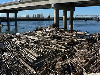
Skagit River at Mount Vernon |
||
|
Gorge Lake - reservoir on the Skagit River |
||
The Skagit River ( ˈskædʒɨt ) is an approximately 240 km long river in the southwest of the Canadian province of British Columbia and in the northwest of the US state Washington .
course
The origin of the river is in the Canadian part of the Northern Cascade Mountains , where it rises in Manning Provincial Park . After initially running parallel to the Crowsnest Highway in a north-westerly direction , it turns south when it reaches the Skagit Range and flows through the Skagit Valley Provincial Park to flow into Ross Lake near the border with the United States , the first of three in the Reservoirs created as part of the Skagit River Hydroelectric Project . The following smaller reservoirs are Diablo Lake and Gorge Lake. All three reservoirs are in the Ross Lake National Recreation Area .
In the further course the valley widens and reaches the coastal plain at Sedro-Woolley . At Mount Vernon the river, which after leaving Ross Lake mainly flows to the west, turns to the south and splits into the North Fork Skagit River and the South Fork Skagit River after about 240 kilometers . Both estuary arms are about 11 km long and flow into the Puget Sound .
The most important tributaries of the Skagit River, whose river system drains an area of 8013 km² on the western slope of the Northern Cascade Range, are
in Canada:
in the United States:
Hydrology
The mean discharge of the Skagit River near the mouth is 471 m³ / s. The highest runoffs usually occur in June. The outflows do not fluctuate very much over the year.
Dams
As part of the Skagit River Hydroelectric Project , three dams were built on the Skagit, primarily to supply the city of Seattle with electricity. The first dam was built in 1924. The water was diverted through the mountains to an electricity station in Newhalem. In 1961, the much larger Gorge High Dam was built on the same site . It serves to fine-tune the water level.
The larger reservoirs were formed by the dams located further up, especially the Diablo and Ross Lake Dam . The reservoir of the Ross dam, the Ross Lake is 39 km long and extends into Canada.
Web links
- Skagit River . In: BC Geographical Names (English)
- Entry on the side of the US Geological Survey (in English)
- Article about the Upper Skagit River Hydroelectric Project at HistoryLink.org (in English)


