
Columbia River
| Columbia River | ||
 Catchment area of the Columbia River with the most important tributaries and dams. |
||
| Data | ||
| Water body number | US : 1140014 | |
| location |
British Columbia (Canada), Washington , Oregon (USA) |
|
| River system | Columbia River | |
| source |
Columbia Lake , British Columbia (Canada) 50 ° 13 ′ 0 ″ N , 115 ° 51 ′ 0 ″ W |
|
| Source height | 808 m | |
| mouth |
Pacific Ocean Coordinates: 46 ° 14 ′ 39 " N , 124 ° 3 ′ 29" W 46 ° 14 ′ 39 " N , 124 ° 3 ′ 29" W |
|
| Mouth height | 0 m | |
| Height difference | 808 m | |
| Bottom slope | 0.41 ‰ | |
| length | 1953 km | |
| Catchment area | 668,217 km² | |
| Drain |
MQ |
7500 m³ / s |
| Left tributaries | Kootenay River , Pend Oreille River , Spokane River , Snake River , Deschutes River , Willamette River | |
| Right tributaries | Okanogan River , Yakima River , Cowlitz River | |
| Big cities | Tri-Cities, WA , Portland, OR , Vancouver, WA | |
| Navigable | To the mouth of the Snake River near Pasco | |
 The Columbia River dammed up to Lake Bonneville |
||
The Columbia River is a 1953 kilometer long river in western North America . It is the most watery of all North American rivers that flow into the Pacific Ocean .
Together with its left tributary , the Snake River , it has a length of 2240 km. Its catchment area covers 668,217 km², of which about 15% are within Canada .
The river is named after the ship Columbia Rediviva of the American captain Robert Gray , who was the first white man to go up the Columbia River on May 11, 1792. Gray traveled to the Pacific Northwest to work with skins to act.
The Lewis and Clark expedition reached the mouth of the river by land from the east in 1805. The Columbia River was first fully mapped by David Thompson in 1814 .
From the 1820s to the 1840s, the York Factory Express , a Hudson's Bay Company trade route between the York Factory on Hudson Bay and Fort Vancouver , followed the course of the river in sections.
geography
The source of the Columbia River is in the Canadian province of British Columbia ; it flows through the middle east of the US state Washington . In the last 480 kilometers before its mouth, the river forms the border between the US states of Washington and Oregon . The extended catchment area extends over the states of Montana and Idaho . At Astoria the Columbia flows into the Pacific. The Columbia is the largest river in the Pacific Northwest region .
It is one of three rivers that break the system of coastal mountains along the North American Pacific coast , creating a connection from the interior of the continent to the coast. The approximately 80 km long section of the river through the cascade chain is called Columbia River Gorge . The Bonneville Dam is also located at this narrow point .
Run and catchment area
With an annual average discharge rate of about 7500 m³ / s, the Columbia River is the largest river in North America, which flows into the Pacific Ocean and the fourth most powerful river in the United States; in terms of the size of the catchment area, the river is in sixth place and in terms of length in twelfth place. The highest runoff ever recorded at The Dalles , Oregon, was 35,113 m³ / s on June 6, 1894. The river has a length of 1953 km from its headwaters to the Pacific. It drains an area of 668,217 km². This includes almost the entire state of Idaho and large parts of British Columbia, Oregon and Washington, but also smaller areas of the surrounding states.
About 85% of the basin and 1199 km of its length is within the United States.
The Columbia Lake in 820 m in height and adjacent Columbia wetlands form the source area in the southern Rocky Mountain Trench , a wide, deep and very long glacial valley between the Canadian Rockies and the Columbia Mountains in British Columbia. For the first 200 miles, the river flows northwest along the trench, flowing through Windermere Lake and the town of Invermere - this region is known as the Columbia Valley in British Columbia - and then over Golden into Kinbasket Lake . It circles the northern end of the Selkirk Mountains and then swings abruptly south through a region known as Big Bend Country . It flows through Lake Revelstoke and the Arrow Lakes ; Revelstoke Lake, Big Bend Country, and the Columbia Valley are known as the Columbia Country in Canada . Below the Arrow Lakes, the Columbia River passes Castlegar - located at the mouth of the Kootenay River - and Trail , the two centers of the West Kootenay region . The Pend Oreille River joins the Columbia River about 2 miles north of the border between Canada and the United States . In the east of Washington State, the Columbia River initially follows a southwesterly direction, forming the southern and eastern borders of the Colville Indian Reservation and the western border of the Spokane Indian Reservation , before heading south and finally near the mouth of the Wenatchee River turns to the southeast. This C-shaped section of the river is also known as the Big Bend . During the Missoula Floods , the water took a more direct route south, forming the Grand Coulee . Later the river found its current course and the Grand Coulee fell dry. The construction of the Grand Coulee Dam in the middle of the 20th century dammed the river back and Banks Lake was created in the earlier bed .
The river flows at The Gorge Amphitheater over, a well-used concert hall in the Pacific Northwest, and passes through the reserve Hanford Reach National Monument and the historic and current nuclear power plants of Hanford Site . The Hanford Reach , between the Priest Rapids Dam and the Tri-Cities , is - with the exception of its estuary - the only section in the United States in which the river is not dammed. The Snake River flows into the Tri-Cities . Eventually the river makes a sharp bend to the west and forms the boundary between Washington and Oregon for the remainder of its course.
The river cuts through the cascade range between The Dalles and Portland . Only three rivers - the other two are the Klamath River in southern Oregon and the Pit River in northern California - break through this mountain range. The Columbia River Gorge is characterized by its strong and steady winds, its beauty and its importance as a transportation route.
The river changes direction again between Portland and Vancouver . From the mouth of the Willamette River to the north-northwest, its flow rate decreases, causing it to dump sediments. The Columbia River empties into the Pacific Ocean below Astoria . The Columbia Bar , a migratory sandbar at the transition to the open sea, makes the estuary one of the most difficult shipping lanes in the world to navigate.
Main tributaries
The Columbia's most powerful tributaries :
| inflow | Flow rate * |
|---|---|
| Snake River | 1611 |
| Willamette River | 1010 |
| Kootenay River (Kootenai) | 867 |
| Pend Oreille River | 788 |
| Cowlitz River | 261 |
| Spokane River | 190 |
| Deschutes River | 170 |
| Lewis River | 136 |
| Yakima River | 100 |
| Wenatchee River | 91 |
| Okanogan River | 86 |
| Kettle River | 83 |
| Sandy River | 64 |
* Annual average flow rate, m³ / s
geology

Volcanic activity in the region can be traced back up to 40 million years. The landscape-defining event between 17 and 14 million years ago was the discharge of large amounts of lava that created the Columbia Plateau basalt , a nearly two-kilometer-thick layer of basalt . It has shaped the landscape through which the river flows to a large extent. During the Pleistocene (the time before the last ice age two million years ago to 700,000 years ago) the river broke through the Cascade Range and formed the Columbia River Gorge .
The river's catchment area experienced one of the largest known floods towards the end of the last Ice Age . The periodic breaking of the ice barriers of glacial Lake Missoula led to discharge rates that were ten times higher than those of all currently existing rivers in the world combined. These processes occurred about forty times over a period of more than a thousand years.

According to estimates, the water levels reached during these Missoula floods at the Wallula Gap 380 m, at the Bonneville Dam 250 m and above today's Portland , Oregon 120 m above today's level. The periodic flooding of the lower Columbia River Plateau deposited large amounts of sediment there and contributed to the fertility of the soil, which is the basis of today's agriculture. These floods also formed some unusual geological formations, such as the Channeled Scablands in eastern Washington.
More recently, the river was dammed by a landslide at the northern end of the Columbia River Gorge, probably in 1700 as a result of an earthquake. This event is known as the " Bridge of the Gods ". The river bed of the Columbia River was completely buried and blocked the drainage until, after a while, the rising water made its way and finally washed away the barrier. In 1980, the eruption of Mount St. Helens deposited large amounts of sediment on the lower reaches, causing the fairway to lose a depth of up to 8 m.
Dams

At the beginning of the 20th century, difficulties in navigating the river were seen as an obstacle to the economic development of the region east of the Cascade Range . The subsequent construction of dams and the dredging of a fairway changed the river forever.
Once wild and rich in salmon , the river is now dammed by dams to generate electricity and control floods . In the east, the water is also used for irrigation . The natural salmon migration will be largely restricted and will soon be partially restored. The electrification and dam project (especially the Grand Coulee Dam ) realized as part of the New Deal was, among other things. set to music by Woody Guthrie ; the song "Roll On Columbia" is dedicated to the Columbia River.
Columbia dams include:
- in Canada:
- Mica Dam (Kinbasket Lake)
- Revelstoke Dam (Revelstoke Lake)
- Keenleyside Dam
- Duncan Dam
- in the United States:
- Grand Coulee Dam in Washington (Franklin Delano Roosevelt Lake)
- Bonneville Dam in northern Oregon or southern Washington
- The Dalles Dam also in northern Oregon and southern Washington
The longest unobstructed section is around 80 km of Hanford Reach in Hanford Reach National Monument , in Benton County , Washington. Around 80% of all king salmon in the upper Columbia River system spawn here .


In 1902 the United States Bureau of Reclamation was established to promote the economic development of the arid states in the western United States. One of his major endeavors was the construction of the Grand Coulee Dam to irrigate 600,000 acres of the Columbia Basin Project in central Washington state. With the beginning of the Second World War , the focus of the dam construction changed from irrigation to the generation of hydropower , irrigation measures only gained importance again in the post-war period.
The expansion of the river takes place under the International Boundary Waters Treaty between the United States and Canada of 1909. During the 1960s, both states signed the Columbia River Treaty . Canada agreed to build three dams in British Columbia and to store the water, and the United States provided half of the resulting increase in power generation on the Columbia River. Canada's commitment includes two reservoirs on the Columbia River and one on the Duncan River ; the last of these was completed in 1973.
“This river may have been created by gods, maybe through glaciers, or the remains of an inland sea, or gravity, or some combination of all of these, but the Army Corps of Engineers controls it today. The Columbia River rises and falls not following the dictates of the tides or rainfall, but rather follows a computerized, statutory, federally established schedule that is only changed when material litigation is resolved or a United States Senator nears his reelection. In this sense he is reliable. "
Today there are 14 dams on the main arm of the Columbia River (three in Canada and eleven in the United States). Four of them and four others on the lower reaches of the Snake River have locks to enable ships and push convoys to travel from the ocean to Lewiston, Idaho. In total, there are more than 400 dams in the Columbia River system . These serve not only for energy generation and irrigation, but also for flood protection , navigability, water level control, drinking water supply and the extraction of public land and Indian reservations.
The larger reservoirs in Washington and Oregon are owned by the federal government of the United States (partly the Army Corps of Engineers and partly the Bureau of Reclamation); the smaller plants are operated by public utilities and private energy producers. The federally owned facilities are known as the Federal Columbia River Power System , which includes 31 dams on the river and its tributaries. This system has changed the seasonal flow of the river to accommodate the greater need for electrical energy during the winter months. At the beginning of the 20th century, April through September accounted for 75% of the river's annual runoff. By 1980 the proportion of the summer months had fallen to around 50%, which practically eliminated the seasonal influence.
The construction of the dams has dramatically changed the landscape and ecosystem on the river. The Columbia River system was once one of the most productive salmon fishing grounds in the world. Previously high-yield fishing grounds, most famous of which are the Celilo Falls in the eastern part of the Columbia River Gorge, have seen a significant drop in salmon catches over the past century. Fish populations have been threateningly reduced, although fish ladders have been set up at some dams to allow fish to migrate to the spawning grounds. There is no such fish ladder at Chief Joseph Dam and therefore fish migration to the upper half of the river system is completely blocked.
In the 2010s, conservation groups had success with lawsuits in federal courts. The Bonneville Power Administration was obliged to create new habitats, especially spawning areas, in the river's catchment area to compensate for the interventions caused by the dam construction. In cooperation with nature conservation organizations, the local Indian peoples and the United States Army Corps of Engineers , land was purchased for renaturation . The largest purchase so far in 2012 is a 372 hectare former farm on the lower reaches of St. Helens , Oregon, which is located in such a way that the dike can be moved back and around 200 hectares can be rewetted and handed over to the flood regime of the river.
Exploring the river

There is some evidence that Spanish castaways reached the shore in 1679 and traded with the Clatsop ; it is not known whether they were actually the first Europeans to see the Columbia River.
The first recorded European whose eye saw the mouth of the Columbia River in 1775 was Bruno de Heceta . On the advice of his officers, he decided not to explore the river as the current was strong and his crew was understaffed. He concluded that it was a cove he called Ensenada de Asunción . Later Spanish maps based on his explorations show a river, the Rio de San Roque, or an opening of the sea, the Entrada de Hezeta .
Based on Heceta's reports, fur trader and captain John Meares searched for the river in 1788 but misinterpreted the currents and concluded that the river did not exist. George Vancouver of the British Royal Navy sailed past the estuary in April 1792 and saw a change in the color of the water, but relied on Meares and continued his voyage north. In the same month he met the American navigator Robert Gray on Juan de Fuca Street , who told him that he had seen the entrance to an estuary and intended to enter it.
Gray returned south and was the first explorer to sail the river on May 12, 1792. Gray's fur trade mission was funded by merchants from Boston , Oregon, who fitted him with a merchant ship called the Columbia Rediviva ; the ship gave the river its name on May 18, 1792. Gray spent nine days near the estuary and then left the area. During this time it had reached a point about 20 kilometers from the mouth of the river as the most distant point. Gray's discovery later formed the basis for the United States' claims to the Oregon Country , which Russia , Great Britain , Spain, and a few other nations also hoped for.
In October 1792, George Vancouver sent Lieutenant William Robert Broughton , his second officer, up the river. Broughton sailed a few miles upriver and then continued the exploration in dinghies. He drove up to the Columbia River Gorge, about 100 miles above the mouth. He sighted and named Mount Hood and Point Vancouver near what is now the city of Vancouver . Broughton formally took possession of the river for the Kingdom of Great Britain , including its catchment area and the adjoining coastline. Gray had failed to take a similar step on behalf of the United States.


Researchers have long speculated about the existence of a Northwest Passage or whether a large river connects the Atlantic Ocean to the Pacific, and some cartographers have mapped such a connection. The Columbia River is at the same latitude as the headwaters of the Missouri River , and it was deduced from this that Gray and Vancouver had discovered the northwest passage they were looking for. A British map from 1798 showed a dotted line connecting the Columbia River to the Missouri River. The American expedition of Meriwether Lewis and William Clark explored the previously unknown country in the American West from 1803-1805 and found no connection between the two rivers. After Lewis and Clark crossed the Rocky Mountains , they built canoes out of hollowed-out logs that they took down the Snake River and reached the Columbia River. They explored the river a few miles up to Bateman Island before descending the Columbia River. At its mouth they ended their expedition and founded Fort Clatsop .
The Canadian explorer David Thompson of the North West Company spent the winter of 1807/1808 in today Invermere near the source of the Columbia River in British Columbia . In 1811 he traveled down the river to the Pacific Ocean, becoming the first white American to travel the river in its full length. It reached the estuary shortly after John Jacob founded Astor's fur trading company, Astoria .
In 1825, physician John McLoughlin founded Fort Vancouver (now Vancouver , Washington) on the bank of the river on behalf of the Hudson's Bay Company . The fort served as the headquarters of the fur trade in the Columbia District and was then the largest white settlement in the Pacific Northwest. Every year ships sailed from London across the Indian and Pacific Oceans to Vancouver to deliver equipment and supplies and exchange them for furs. The fort became the last chance for the settlers on the Oregon Trail to get supplies. Because of its access to the Columbia River, Fort Vancouver's influence extended to the area from Alaska to California and from the Rocky Mountains to Hawaii .
The first French Canadians of the North West Company called the river Ouragan (German: "Orkan"), which is one of several plausible origins for the toponym Oregon .
The United States and British North America agreed to settle the Oregon area together in 1818 . The Americans generally stayed south of the river while the British settled the area to the north. The course of the river was considered a possible boundary line during the later Oregon dispute; however, the Oregon Compromise of 1846 established latitude 49 as the border between the United States and Canada . The course of the river later determined most of the border between the US territories of Oregon and Washington. Oregon became a state of the United States in 1857 and Washington followed in 1889.
shipping


The navigators Robert Gray and George Vancouver had proven in 1792 that it was possible to pass the sandbar at the mouth of the river, but the navigational difficulties caused by this obstacle are still a current problem today. Despite modern hydraulic engineering measures that changed the course at the mouth of the river, the strong currents and variability of the sandbanks make the journey between the river and the open ocean a challenge.
The use of steamers began on the Columbia River around 1850, contributing to the rapid settlement and economic development of the region. The steamers operated on different stretches of the river: on the lower reaches between the Pacific Ocean and the Cascades Rapids , between Celilo Falls and the mouth of the Snake River; on Wenatchee Reach in east Washington, on the Arrow Lakes in British Columbia and on various tributaries such as the Willamette River or the Snake River and on Kootenay Lake . Railways connected the individual steamship connections, where these were interrupted by waterfalls on the lower reaches.
Passage to Lewiston
As early as 1881, industrialists suggested modifying the natural course of the river to improve navigability. These hydraulic engineering measures include the construction of jetties at the mouth of the river, the dredging of the river bed and the construction of locks and a canal. Today ocean ships can sail as far as Portland and shipping is possible across the Snake River to Lewiston , Idaho.
The Columbia Bar is a changeable sandbar at the mouth of the river that makes travel between the river and the open ocean difficult and dangerous, and numerous rapids impede navigation. In 1886 the first jetties were built to extend the course of the river into the sea.
In 1891 the Columbia River was dredged to improve navigability. The depth of the fairway between the confluence with the sea and Portland and Vancouver was increased from 5 m to 8 m. The Columbian newspaper called for a deepening to 12 m as early as 1905, but this depth was only reached in 1976.
The first lock system on the Cascades Rapids was built in 1895 to allow ships to travel safely through the Columbia River Gorge. The Celilo Canal , which bypasses the Celilo Falls, opened to traffic in 1915. In the mid-20th century, the rapids sank into a series of reservoirs along the river. A system of locks enables ships to get from one reservoir to the next. A shipping canal along the Columbia and Snake Rivers that allows shipping to Lewiston, Idaho, was completed in 1975. More than 40% of all United States wheat exports are shipped on the Columbia River.
The 1980 eruption of Mount St. Helens caused numerous landslides, reducing the depth of the Columbia River fairway by eight meters over a seven-kilometer stretch and hampering Portland's economy.
Deepening of the fairway

Efforts to make the river usable for shipping and to expand the fairway continue to the present day. In 1990 a new round of investigations into the dredging of the lower reaches was started. These plans were controversial from the start with regard to their economic viability and environmental compatibility .
In 1999 the United States Congress approved the deepening of the river bed between Portland and Astoria from 40 feet to 43 feet so that large container ships and wheat carriers can reach Portland and Vancouver. The project envisaged measures to compensate for the resulting damage to the environment; for every acre destroyed by the project, the Army Corps of Engineers had to create 12 acres of new wetland . The project met with resistance, however, because it would throw up toxic deposits at the bottom of the river bed. A lawsuit against the Army Corps of Engineers was denied by the United States Court of Appeals for the Ninth Circuit in August 2006 .
Work on the project began in 2005. The cost was 150 million US dollars estimated that of which federal government 65% and the state 27 million Oregon and Washington each pay US dollars. The rest is provided by six port operating companies. The project cost $ 178 million and was completed in October 2010.
More pictures

Columbia River near Revelstoke (Canada).
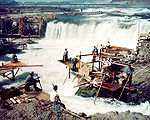
Celilo Falls, with the Oregon Trunk Rail Bridge in the background
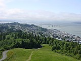
Estuary into the Pacific at Astoria.

Vista House , with Beacon Rock and Hamilton Mountain in the background.


Designations
The Canadian province of British Columbia , Columbia County in Oregon, and Columbia County in Washington are named after the river.
See also
Web links
- Columbia River ( English, French ) In: The Canadian Encyclopedia .
- Columbia River in the Geographic Names Information System of the United States Geological Survey (English)
- Columbia River . In: BC Geographical Names (English)
- Photo Gallery (English)
- Biodiversity Atlas for the Columbia River Basin in British Columbia
- Where Have All the Native Fish Gone ?: The Fate of Fish That Lewis and Clark Encountered on the Lower Columbia River ( September 2, 2006 memento in the Internet Archive ) by Virginia L. Butler. In: Oregon Historical Quarterly , Fall 2004 edition
Individual evidence
- ↑ a b c d Bill Lang: Columbia River . Center for Columbia River History. 2008. Retrieved July 1, 2008.
- ↑ Willam G. Loy, Stuart Allan, Aileen R. Buckley, James E. Meecham: Atlas of Oregon . University of Oregon Press, 2001, pp. 24 .
- ↑ a b J.C. Kammerer: Largest Rivers in the United States . US Geological Survey. May 1990. Retrieved July 6, 2008.
- ↑ Michele Gerber: Legend and Legacy: Fifty Years of Defense Production at the Hanford Site. In: Document 51: Excerpt from Legend and Legacy. Center for the Study of the Pacific Northwest, 1992, accessed September 20, 2015 .
- ^ Columbia River History: Hydropower . Northwest Power and Conservation Council. Retrieved July 6, 2008.
- ↑ Largest Rivers in the United States , USGS ; Retrieved January 15, 2008.
- ^ RA Kimbrough: Water Data Report WA-05-1: Klickitat and White Salmon River Basins and the Columbia River from Kennewick to Bonneville Dam (PDF; 1.4 MB) In: Water Resources Data-Washington Water Year 2005 . United States Geological Survey. 2006. Retrieved April 1, 2008.
- ^ William G. Loy, Stuart Allan, Aileen R. Buckley, James E. Meecham: Atlas of Oregon . University of Oregon Press, 2001, pp. 164-165 .
- ↑ 49 ° 0 ′ 13 ″ N , 117 ° 37 ′ 13 ″ W.
- ^ Peter Kowalski: Health consultation . In: Colville Federated Tribes . United States Department of Health and Human Services . March 7, 2001. Retrieved July 10, 2008.
- ^ William Joe Simonds: Columbia Basin Project: Research on Historic Reclamation Projects (Second Draft) . Bureau of Reclamation History Program, Denver, Colorado. Archived from the original on June 21, 2008. Retrieved July 9, 2008.
- ^ Oregon's Publicly-Owned Waterways . In: Public Ownership of Submerged and Submersible Land . Oregon Department of State Lands. Archived from the original on May 27, 2010. Info: The archive link was inserted automatically and has not yet been checked. Please check the original and archive link according to the instructions and then remove this notice. Retrieved July 10, 2008.
- ^ Columbia River Gorge National Scenic Area . USDA Forest Service. Retrieved July 10, 2008.
- ↑ Ben Jacklet: Columbia pilot pay attracts port's eye. In: Portland Tribune . October 19, 2004, archived from the original on February 6, 2012 ; Retrieved July 10, 2008 .
- ^ The Geologic History of the Columbia River Gorge ( English ) USGS . 2001. Retrieved April 2, 2008.
- ^ Glacial Lake Missoula and the Missoula Floods . US Geological Survey. Retrieved July 1, 2008.
- ↑ Michael C. Houck, Cody, MJ: Wild in the City . Oregon Historical Society, 2000.
- ^ Lee B. Reeder: Open the Columbia to the Sea. (No longer available online.) In: Reprint of an edition of the Pendleton Daily Tribune. Center for Columbia River History, 1902, archived from the original May 14, 2008 ; accessed on June 26, 2008 . Info: The archive link was inserted automatically and has not yet been checked. Please check the original and archive link according to the instructions and then remove this notice.
- ↑ Wild salmon 1: Species declining fast. In: Morning Edition. National Public Radio, June 10, 1991, accessed July 12, 2009 .
- ↑ Anna King: The Modern Day Columbia River - Part Two: Still Waters Run Deep And Deadly For Columbia River Salmon. Oregon Public Broadcasting, October 2, 2007, accessed July 12, 2009 .
- ^ Bureau of Reclamation - About Us . US Department of the Interior, Bureau of Reclamation. 2008. Archived from the original on September 28, 2017. Info: The archive link was inserted automatically and has not yet been checked. Please check the original and archive link according to the instructions and then remove this notice. Retrieved July 12, 2009.
- ↑ Timothy Egan: The Good Rain . Knopf, 1990, ISBN 0-394-57724-8 (English, This river may have been shaped by God, or glaciers, or the remnants of the inland sea, or gravity or a combination of all, but the Army Corps of Engineers controls it now. The Columbia rises and falls, not by the dictates of tide or rainfall, but by a computer-activated, legally-arbitrated, federally-allocated schedule that changes only when significant litigation is concluded, or a United States Senator nears election time . In that sense, it is reliable. ).
- ^ Paul Pitzer: Grand Coulee: Harnessing a Dream . Washington State University Press, Pullman, Washington 1994, ISBN 978-0-87422-110-7 .
- ^ Managing The Columbia River: Instream Flows, Water Withdrawals, and Salmon Survival . National Academies Press, 2004, ISBN 0-309-09155-1 , pp. 4, 22 ( online [accessed July 12, 2009]). (Link to Google Book Search )
- ↑ Leonard A. Fulton: Spawning areas and abundance of Chinook salmon (Oncorhynchus tshawytscha) in the Columbia River Basin: past and present ( Memento of the original from February 1, 2012 in the Internet Archive ) Info: The archive link was automatically inserted and not yet checked . Please check the original and archive link according to the instructions and then remove this notice. (PDF; 3.6 MB), United States Fish and Wildlife Service, 1968
- ^ Don W. Chapman: Salmon and Steelhead Abundance in the Columbia River in the Nineteenth Century . In: Transactions of the American Fisheries Society 1986, Volume 115, pp. 662-670. doi : 10.1577 / 1548-8659 (1986) 115 <662: SASAIT> 2.0.CO; 2
- ↑ Oregonlive.com: 920-acre former ranch on Columbia River to be restored to estuary and prime fish habitat . January 24, 2012
- ^ A b c d Hayes: Historical Atlas of the Pacific Northwest: Maps of Exploration and Discovery . Sasquatch Books, Seattle, Washington 1999.
- ↑ a b Kit Oldham: Captain Robert Gray Becomes the first non-Indian navigator to enter the Columbia River, Which he later names, on May 11, 1792 . In: The Online Encyclopedia of Washington State History . History Ink. January 13, 2003. Retrieved June 24, 2008.
- ^ Melvin C. Jacobs: Winning Oregon: A Study of An Expansionist Movement . The Caxton Printers, Ltd, 1938, p. 77 .
- ^ A b c d The Oregon Story: A Chronology of Ports in Oregon. Oregon Public Broadcasting , January 18, 2007, accessed July 1, 2008 .
- ^ Edward L. Affleck: A Century of Paddlewheelers in the Pacific Northwest, the Yukon, and Alaska . Alexander Nicholls Press, Vancouver, BC 2000, ISBN 0-920034-08-X , pp. 6 .
- ^ Howard McKinley Corning: Willamette Landings (2nd Ed.) . Oregon Historical Society, Portland, Ore. 1977, ISBN 0-87595-042-6 .
- ^ Fritz Timmen: Blow for the Landing . Caxton Printers, Caldwell, Idaho 1972, ISBN 0-87004-221-1 .
- ^ Rewind - Editorials from our archives: 1905: 40 ft depth wanted. The Columbian Publishing Co., December 26, 2005, accessed July 1, 2008 .
- ^ The Oregonian , Jan. 1, 1895, p. 8
- ↑ Harvey W. Scott, Leslie M. Scott: History of the Oregon Country, Vol. 3 . Riverside Press, Cambridge 1924, pp. 190 ( online ).
- ↑ The Dalles-Celilo Canal on Columbia River opens to traffic on May 5, 1915. . HistoryLink.org. Retrieved July 1, 2008.
- ^ Supporting Columbia-Snake River Commerce ( English , PDF) Northwest RiverPartners. Archived from the original on June 25, 2008. Retrieved July 1, 2008.
- ↑ Harris, Stephen L. (1988). Fire Mountains of the West: The Cascade and Mono Lake Volcanoes . Missoula: Mountain Press Publishing Company, Missoula. page 209. ISBN 0-87842-220-X
- ↑ Hopper Dredges ( English ) GlobalSecurity.org. August 2000. Retrieved July 1, 2008.
- ↑ Cleanup study already bogged in controversy. In: The Oregonian. January 21, 1990. Retrieved June 27, 2008 .
- ↑ a b c Tom Koenninger: Dredging Columbia a very big job. In: The Columbian. March 7, 2007, accessed June 27, 2008 .
- ↑ In our view - monitor the dredging. In: The Columbian. August 26, 2006, accessed July 1, 2008 .
- ↑ Bush budget offers $ 15 million for dredging. In: The Columbian. February 8, 2006, accessed July 1, 2008 .
- ↑ James Mayer: Oregon, Washington officials praise completion of Columbia River dredging , October 21, 2010, accessed January 7, 2011
In Canada: Mica (Kinbasket Lake) | Revelstoke (Revelstoke Lake) | Hugh Keenleyside (Arrow Lakes)
In the USA: Grand Coulee ( Franklin Delano Roosevelt Lake ) | Chief Joseph ( Rufus Woods Lake ) | Wells ( Lake Pateros ) | Rocky Reach ( Lake Entiat ) | Rock Island ( Rock Island Pool ) | Wanapum (Lake Wanapum) | Priest Rapids (Priest Rapids Lake) | McNary (Lake Wallula) | John Day ( Lake Umatilla ) | The Dalles ( Lake Celilo ) | Bonneville (Lake Bonneville)