
Idaho
| Idaho | |||||
|---|---|---|---|---|---|
| |||||
  | |||||
| Capital: | Boise | ||||
| State motto: | Esto perpetua | ||||
| Surface: | 216,446 km² | ||||
| Residents: | 1,567,582 (2010 Census) | ||||
| Member since: | July 3, 1890 | ||||
| Time zone: | North Idaho UTC − 8 ( PST ) UTC − 7 (daylight saving time) South Idaho UTC − 7 ( MST ) UTC − 6 (daylight saving time) |
||||
| The highest point: | 3,859 m ( Borah Peak ) | ||||
| Average Height: | 1,524 m | ||||
| Deepest point: | 216 m ( Snake River ) | ||||
| Governor : | Brad little ( r ) | ||||
| Post / Office / ISO | ID / ID / US-ID | ||||
 | |||||


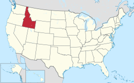
Idaho ( English pronunciation [ ˈaɪ̯dəhoʊ̯ ] ) is a state in the northwestern United States with a population of 1,787,065 (2019 estimate). It is one of the sparsely populated states. The capital is Boise . The state is also known as the Gem State . The name of the state of Idaho probably comes from the Indian word "Ee-dah-how" of the Shoshone , which roughly means "light on the mountains". According to other claims, this translation is said to be a free invention by the eccentric mining lobbyist George M. Willing .
geography
Basic data
Of the 216,446 km² large state area (14th place among the federal states), 2133 km² are water surface (1%). Around 47% of the country is forested. The highest point in Idaho is Borah Peak (3859 m) in Custer County .
Extension of the national territory
Idaho has a maximum latitude of 491 km between 110 ° W to 117 ° W and a longitude of 771 km between 42 ° N to 49 ° N.
- Neighbore states
Idaho borders the states of Washington , Oregon , Nevada , Utah , Wyoming, and Montana, as well as the Canadian province of British Columbia . The elongated strip of Idaho between Washington and Montana is called the Idaho Panhandle in English . The word panhandle for pan handle is often used in English for area corridors or other narrow sections of land.
- structure
A historic county of Idaho was Alturas County .
Landscapes
.jpg)
The landscape in Idaho is predominantly mountainous with vast pristine areas. The south of the state is shaped by the arc of the Snake River Plain , a plain that stretches over 600 km from east to west through the entire state. Your immediate environment is influenced by the basin and range structure of the Great Basin . All of the rest of the state is part of the Rocky Mountains . The Sawtooth Range is known as Idaho's most famous mountain range. Other mountain ranges in Idaho include the Bitterroot Range on the Montana border , the Clearwater Mountains , which extend from there to the Salmon River, the Salmon River Mountains , the Lost River Range, and the White Cloud Mountains .
Mineral resources are abundant.
Rivers
The larger rivers of Idaho are the Snake River, the Clearwater River , the Clark Fork River with the Pend Oreille River and the Salmon River .
water falls
.jpg)
The waters of the Snake River rush through Hells Canyon , which is deeper than the Grand Canyon . The Shoshone Falls overthrow of rugged cliffs from a greater height to the depth than the Niagara Falls .
Lakes
- Alturas Lake (Sawtooth National Recreational Area)
- Coeur d'Alene Lake
- Lake Pend Oreille
- Payette Lake (McCall)
- Petit Lake (Sawtooth National Recreational Area)
- Priest Lake
- Redfish Lake (Sawtooth National Recreational Area)
- Sawtooth Lake (Sawtooth National Recreational Area)
population
| Population development | |||
|---|---|---|---|
| Census | Residents | ± in% | |
| 1870 | 14,999 | - | |
| 1880 | 32,610 | 117.4% | |
| 1890 | 88,548 | 171.5% | |
| 1900 | 161,772 | 82.7% | |
| 1910 | 325,594 | 101.3% | |
| 1920 | 431,866 | 32.6% | |
| 1930 | 445.032 | 3% | |
| 1940 | 524,873 | 17.9% | |
| 1950 | 588,637 | 12.1% | |
| 1960 | 667.191 | 13.3% | |
| 1970 | 712,567 | 6.8% | |
| 1980 | 943.935 | 32.5% | |
| 1990 | 1,006,749 | 6.7% | |
| 2000 | 1,293,953 | 28.5% | |
| 2010 | 1,567,582 | 21.1% | |
| 2019 estimate | 1,787,065 | 14% | |
| Before 1900
1900-1990 2000 |
|||

Idaho has 1,567,582 inhabitants (as of: Census 2010), of which 82.8% white (excluding Hispanics and Latinos), 1.7% Indians , 1.4% Asian Americans , 0.8% African American . 12.0% of the population described themselves as Hispanics or Latinos . Over three-quarters of Idaho's population descended from ancestors in Europe. People of German origin form the largest group with 21.8%.
Religions
The religious communities with the largest membership in 2000 were the Church of Jesus Christ of Latter-day Saints with 311,425, the Catholic Church with 130,847, the Assemblies of God with 18,745 and the United Methodist Church with 17,683.
Biggest cities

As of 2017 according to estimates by the US Census Bureau
history

Idaho was explored by Lewis and Clark as early as 1805 . About 8,000 Indians lived in the area at that time .
First, Idaho was part of the territories of Oregon and Washington . The fur trade and missionary activity allowed the first settlers to break into the region. Thousands roamed Idaho during the California gold rush , only a few settled in Idaho. On March 4, 1863, US President Abraham Lincoln signed a law that created the Idaho Territory . At that time the total population was below 17,000.
In 1865 Boise became capital in place of Lewiston . When gold was discovered in Idaho in 1866 and the transcontinental railroad was completed in 1869, Idaho attracted large numbers of people, particularly Chinese immigrants, to work in the mines. In 1877, as part of the campaign against the Nez Percé in Idaho, there were several skirmishes between the American army and Nez Percé Indians. The Indians were very successful in this, but eventually fled to Wyoming and Montana, pursued by the Americans.
President Benjamin Harrison signed a bill making Idaho the 43rd state to join the United States on July 3, 1890. The population at that time was 88,548. The 1889 constitution is still in force.
After it was established as a state, mining and other industries became a major factor in the economy. In the 1890s, Idaho exported more lead than any other state. Although Idaho's dependence on mining has decreased, the state remains a major producer of silver and lead. In the 1950s and 1960s, Idaho residents were contaminated by radioactive fallout from the Nevada National Security Site . The federal government was working on a solution to compensate the victims.
politics

Idaho is one of the most conservative states in the United States because of its rural and religious population; accordingly, the Republicans have not lost in any presidential election here since 1964 . At that time, Lyndon B. Johnson , who was re-elected nationwide by a large margin, narrowly beat Republican challenger Barry Goldwater in Idaho . In the 2012 election, Mitt Romney clearly won with 64.5% against Barack Obama (32.62%). Both current US Senators , Jim Risch and Mike Crapo , are Republicans; also in the House of Representatives of the 112th Congress , these take the two seats of the state through Raúl Labrador and Mike Simpson .
Idaho has a bicameral parliament consisting of the Idaho House of Representatives and the Idaho Senate . Both chambers are considered part-time parliaments and are elected every two years. Since the last elections in 2014, the Republican Party has provided 56 of the 70 representatives and 28 of the 35 senators, each corresponding to 80 percent.
congress
Governors
Natural monuments
The National Park Service (NPS) identifies a National Park , three National Historic Trails , a National Geologic Trail , a National Reserve , a National Preserve (also a National Monument) and one or two National Monuments for Idaho :
- Yellowstone National Park
- California Trail
- Lewis and Clark National Historic Trail
- Oregon Trail
- Ice Age Floods National Geologic Trail
- City of Rocks National Reserve
- Craters of the Moon National Monument and Preserve
- Hagerman Fossil Beds National Monument
There are also eleven National Natural Landmarks (as of September 30, 2017).
Cultural monuments

The NPS maintains a National Historic Site and a National Historical Park in Idaho :
There are also ten National Historic Landmarks and 1,041 structures and sites in Idaho that are registered on the National Register of Historic Places (as of September 30, 2017).
Economy and Infrastructure
The real gross domestic product per capita (English per capita real GDP) was USD 39,970 in 2016 (national average of the 50 US states: USD 57,118; national ranking: 49). The unemployment rate was 2.9% in November 2017 (national average: 4.1%).
Agricultural products are beef , potatoes ( Idaho potatoes ), sugar , dairy products , wheat and barley . Wine is also grown . The industrial products are wood products, machinery, computer hardware, chemical products, paper products, silver and other mineral resources. Tourism is an important industry.
Education and Research
State colleges include Boise State University , Idaho State University , Lewis-Clark State College, and the University of Idaho . Additional colleges can be found on the Idaho Universities List . To the northwest of Idaho Falls is the Idaho National Laboratory .
literature
- Adam M. Sowards (Ed.): Idaho's Place: A New History of the Gem State. University of Washington, Seattle 2016, ISBN 978-0-295-99556-4 .
Web links
- Web presence of the state (English)
Individual evidence
- ↑ Population according to census.gov
- ↑ US Census Bureau QuickFacts: Idaho. Retrieved April 22, 2020 (English).
- ↑ museumofhoaxes.com
- ↑ sawtooth range ( Memento from June 15, 2011 in the Internet Archive ) on idahoaclimbingguide.com (English)
- ↑ https://www.census.gov/quickfacts/fact/table/ID/PST045219
- ↑ US Census Bureau Census of Population and Housing . Retrieved February 28, 2011
- ↑ Extract from Census.gov . Retrieved February 28, 2011
- ↑ Excerpt from factfinder.census.gov.Retrieved February 28, 2011
- ↑ United States Census Bureau ( memento June 23, 2012 on WebCite )
- ↑ thearda.com ( Memento from August 29, 2008 in the Internet Archive )
- ↑ Idaho. In: nps.gov. Retrieved November 21, 2018.
- ↑ Idaho. In: nps.gov. Retrieved November 21, 2018.
- ^ US Department of Commerce, BEA, Bureau of Economic Analysis: Bureau of Economic Analysis. Retrieved August 27, 2017 (American English).
- ^ Unemployment Rates for States. Retrieved January 8, 2018 .
States:
Alabama |
Alaska |
Arizona |
Arkansas |
Colorado |
Connecticut |
Delaware |
Florida |
Georgia |
Hawaii |
Idaho |
Illinois |
Indiana |
Iowa |
California |
Kansas |
Kentucky |
Louisiana |
Maine |
Maryland |
Massachusetts |
Michigan |
Minnesota |
Mississippi |
Missouri |
Montana |
Nebraska |
Nevada |
New Hampshire |
New Jersey |
New Mexico |
New York |
North Carolina |
North Dakota |
Ohio |
Oklahoma |
Oregon |
Pennsylvania |
Rhode Island |
South Carolina |
South Dakota |
Tennessee |
Texas |
Utah |
Vermont |
Virginia |
Washington |
West Virginia |
Wisconsin |
Wyoming
Federal District:
Washington, DC
External Areas:
American Samoa |
American Virgin Islands |
Baker Island |
Guam |
Howland Island |
Jarvis Island |
Johnston Atoll |
Kingman attack |
Midway Islands |
Navassa |
Northern Mariana Islands |
Palmyra Atoll |
Puerto Rico |
Wake up
List of counties in Idaho
Ada |
Adams |
Bannock |
Bear Lake |
Benewah |
Bingham |
Blaine |
Boise |
Bonn |
Bonneville |
Boundary |
Butte |
Camas |
Canyon |
Caribou |
Cassia |
Clark |
Clearwater |
Custer |
Elmore |
Franklin |
Fremont |
Gem |
Gooding |
Idaho |
Jefferson |
Jerome |
Kootenai |
Latah |
Lemhi |
Lewis |
Lincoln |
Madison |
Minidoka |
Nez Perce |
Oneida |
Owyhee |
Payette |
Power |
Shoshone |
Tetons |
Twin Falls |
Valley |
Washington
Coordinates: 44 ° 25 ′ N , 114 ° 3 ′ W