Michigan
| Michigan | |||||
|---|---|---|---|---|---|
| |||||
| List of states | |||||
| Capital: | Lansing | ||||
| State motto: |
Si quaeris peninsulam amoenam, circumspice (Latin: 'If you are looking for a lovely peninsula, look around') |
||||
| Surface: | 250,494 (land = 147,121, water = 103,372) km² | ||||
| Residents: | 9,928,300 (2016 estimated) (39.4 U / km²) | ||||
| Member since: | January 26, 1837 | ||||
| Time zone: | Eastern: UTC − 5 / −4 | ||||
| The highest point: | 603 m ( Mount Arvon ) | ||||
| Average Height: | 275 m | ||||
| Deepest point: | 174 m Lake Erie | ||||
| Governor : | Gretchen Whitmer ( D ) | ||||
| Post / Office / ISO | MI / / US MI | ||||
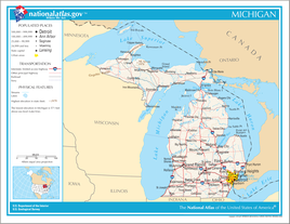
| Map of Michigan | |||||
Michigan ( English pronunciation [ ˈmɪʃɪgən ] , Ojibwe "big lake") is a state of the United States . It is known as the birthplace of the automotive industry, but it also has a large tourism industry. Destinations such as Traverse City , Mackinac Island and the entire Upper Peninsula attract athletes and nature lovers, especially from all over the USA and Canada . Michigan, which consists of two large peninsulas, has the longest freshwater coast of any US state due to its location on the Great Lakes . Michigan has the nickname of Great Lakes State , State of the Great Lakes ' , Wolverine State , Wolverine -State' , the middle state , Mitten State ' and Water Winter Wonderland , Water Winter Wonderland' .
geography
relief
Michigan is the only state in the United States whose mainland is divided in two. Lake Michigan stretches between the two parts . Upper Michigan, the northern part, is located between Lake Michigan to the south and Lake Superior to the north. The western part is characterized by the Superior Upland , a highland with a granitic bedrock. The upland consists of several north-east to south-west trending mountain ranges that extend west to Wisconsin and Minnesota . Individual mountain ranges in the Upland are the Porcupine Mountains and the Gogebic Range and Copper Range . The Superior Upland has much greater differences in altitude than the rest of the state. The highest point in Michigan is Mount Arvon at 603 m. The Isle Royale in Lake Superior also belongs to Michigan, although both the Canadian province of Ontario and the US state of Minnesota are much closer to the island.
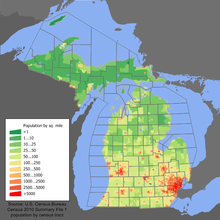
The southern part, Lower Michigan, is located between Lake Michigan (west) and Lake Huron (east). In terms of area, this is the greater part of the state. The vast majority of the state's population lives in the southernmost third of lower Michigan. All of Lower Michigan and the eastern part of Upper Michigan are part of the Eastern Great Lakes Lowland. This is a flat to hilly lowland and was created as a result of the glaciers that covered the land in the Ice Age. The average height is 274 m and the lowest point is approx. 173 m. As a result, there are hardly any noticeable differences in altitude within sub-Michigan.
ground
The soil in Upper Michigan is grayish-brownish and acidic. It emerged from glacial deposits and is sometimes not very fertile or not at all. Because of this and due to the climate, there is hardly any agriculture there. In the southeast of Michigan, at Saginaw Bay , there is heavy, loamy soil. Most of Lower Michigan, however, has very fertile soil, which is also used for agriculture.
rivers and lakes
Michigan has a share in four of the five Great Lakes . These are Lake Michigan, Lake Huron, Lake Upper, and Lake Erie . As a result, it has a total coastline of 5310 km. There are also more than 11,000 smaller lakes, the largest of which is Houghton Lake in northern Lower Michigan.
The longest river in the state is the Grand River . Other important rivers are the Kalamazoo , Manistee, Saint Clair, Detroit and Saint Joseph. Goods can be shipped all over the world through the waterways, because there is a connection to the Atlantic via Lake Erie and the St. Lawrence River . There are some waterfalls in Upper Michigan , such as the Tahquamenon Falls .
climate

The climate in Michigan has a special position compared to the rest of the United States. This is due to its proximity to the Great Lakes. These give Michigan a milder climate compared to other states of the same latitude. It is humid and continental (a very rare combination worldwide) and lies in the cool, temperate climate zone. However, the climates of Upper and Lower Michigan must be considered separately.
Upper Michigan is significantly cooler and has a Nordic climate. The average frost-free period is only 60 to 120 days per year. The winters are very severe and the summers mild. The average annual temperature in Sault Ste. Marie near the border with Canada in northeastern Upper Michigan is 4.3 ° C. The warmest month is July with 18 ° C, the coldest are January and February with −10 ° C. The average annual precipitation is 869 mm and is spread over the entire year.
The climate in Lower Michigan, however, is mild. The average frost-free time is 180 to 240 days, which is significantly longer than in Upper Michigan. In Detroit (in southeastern Lower Michigan) the average temperature is 10 ° C. The warmest month is July with 24 ° C, the coldest is January with −5 ° C. Overall temperatures are 5 ° C higher than in Upper Michigan. At 18 ° C, the temperature difference is small for a continental country. This is due to the influence of the Great Lakes. In summer they cool the air and in winter they store heat and warm the air. However, the temperature difference is still significantly higher than on the coast of the sea, which is why the Michigan climate is considered to be of the continental type despite the influence of the lakes. Precipitation is here all year round, but slightly lower at 691 mm.
Neighbore states
Michigan has land borders with Ohio and Indiana to the south . In addition, the Upper Peninsula has a land border with Wisconsin in its southwest . There is also a border with Illinois via Lake Michigan and a border with Minnesota via Lake Superior . The border with the Canadian province of Ontario runs through Lake Superior, Lake Huron , Lake Erie and their connecting waters.
Although there is no land border with Illinois, the southwest of the state still belongs to the greater Chicago area , which is faster to reach from there than Detroit.
Biggest cities

- List of all Michigan municipalities (in alphabetical order)
- List of cities in Michigan by population (10,000+ residents)
structure
economy
Michigan's economic output was USD 487 billion in 2016, making it the thirteenth-highest economic output of any US state and a 2.64% share of the entire American economy. Counted as a separate country, Michigan's economic output would be roughly the same as Poland's . The real gross domestic product per capita GDP was USD 49,074 in 2016 (national average of the 50 US states: USD 57,118; national ranking: 37). The unemployment rate was 4.6% in November 2017 (national average: 4.1%).
economic sectors
Michigan has a diverse economy. The primary ( agriculture / mining ) and secondary ( industrial ) sectors are of the utmost importance to the economic area. Agriculture grew in Michigan in the first half of the 19th century and continues to this day. The main agricultural products are dairy products , corn , soybeans and cattle. Michigan is also a leader in the production of cherries and apples . About 3 billion US dollars to be taken by crops. The timber industry does not play an essential role. It is mainly operated in western Upper Michigan; the wood is mostly used to make paper. Fisheries also contribute little to the economy. The annual catch is worth only $ 11 million.
Mining plays a vital role in Michigan. It is an important pillar for the industry. There are abundant deposits of ores and natural gas and oil are also extracted in the central north and south. The most important raw materials are iron ore , petroleum , natural gas and copper . The extraction of salt is also very important. Michigan is also an important exporter of gravel , peat , silver and potash , which are extracted from the numerous swamps.
Michigan is one of the most important industrial nations in the USA. It is a leader in the manufacture of passenger cars. Detroit is one of the most important centers. The headquarters of the three major automobile manufacturers Chrysler , General Motors and Ford are located here . Other centers of the automotive industry are Flint , Lansing and Pontiac . Other important industrial products are engines and construction machinery. Metal alloys such as steel are also produced, primarily in Detroit. Food industry (see: Breweries in Michigan ) as well as chemical and pharmaceutical products are also significant. Michigan industry accounts for 27% of the gross domestic product.
The largest service sector is tourism. This branch of the economy brings in 6.3 billion US dollars annually for the scenic state. There are also extensive recreational opportunities, such as water sports and summer swimming in many coastal areas of the Great Lakes. In the cold and relatively snowy winters, the winter sports facilities attract tourists.
Infrastructure
Michigan has a well-trained infrastructure. There is a vast network of highways totaling 189,000 km, of which 1,890 km are interstate highways .
On land, goods are usually transported via the rail network, which is still approx. 4000 km long and, compared to other states, well-developed, because many rivers are not navigable. However, many secondary railway lines were also shut down in the second half of the 20th century. On the coasts to the Great Lakes there are large port cities for import and export such as Calcite and Escanaba . On the Great Lakes, the Sault-Saint-Marie Canals and the Saint-Clair and Detroit Rivers are significant as they connect Lake Huron and Lake Erie, thus providing a link to the Atlantic Ocean. The Saint Mary's is also important. This connects the Upper Lake with the Huron Lake.
With the Detroit Metropolitan Wayne County Airport there is an international airport that is one of the largest in the USA.
In cooperation with private companies, Michigan launched the project for the commissioning of a separate lane for autonomous vehicles , which is unique in the USA, on August 1st, 2020 . The 65 kilometer stretch of motorway along the Interstate 94 corridor will initially connect Detroit with the city of Ann Arbor . As a first step, a two-year study will examine the extent to which either existing lanes have to be used or new lanes have to be built.
population
| Population development | |||
|---|---|---|---|
| Census | Residents | ± in% | |
| 1800 | 3757 | - | |
| 1810 | 4762 | 26.8% | |
| 1820 | 7452 | 56.5% | |
| 1830 | 28.004 | 275.8% | |
| 1840 | 212.267 | 658% | |
| 1850 | 397.654 | 87.3% | |
| 1860 | 749.113 | 88.4% | |
| 1870 | 1,184,059 | 58.1% | |
| 1880 | 1,636,937 | 38.2% | |
| 1890 | 2,093,890 | 27.9% | |
| 1900 | 2,420,982 | 15.6% | |
| 1910 | 2,810,173 | 16.1% | |
| 1920 | 3,668,412 | 30.5% | |
| 1930 | 4,842,325 | 32% | |
| 1940 | 5,256,106 | 8.5% | |
| 1950 | 6,371,766 | 21.2% | |
| 1960 | 7,823,194 | 22.8% | |
| 1970 | 8,875,083 | 13.4% | |
| 1980 | 9,262,078 | 4.4% | |
| 1990 | 9,295,297 | 0.4% | |
| 2000 | 9,938,444 | 6.9% | |
| 2010 | 9,883,640 | -0.6% | |
| Before 1900
1900–1990 2000 + 2010 |
|||
The 2010 national census found a population of 9,883,640, of which 76.6% white, 14.2% African-Americans, 0.6% Native Americans, 2.4% Asian and 4.4% Hispanic. Michigan is the only one of the 50 US states that has had its population decline since the last census in 2000. Only in the US suburb of Puerto Rico did it also decline.
Religions
The religious communities with the largest number of members in 2000 were the Catholic Church with 2,019,926, the Lutheran Church - Missouri Synod with 244,231, the United Methodist Church with 222,269 and the Evangelical Lutheran Church in America with 160,836 followers.
history
Once a major supplier of wood , iron and copper , Michigan became the birthplace of the auto industry after its natural resources began to decline in the early 20th century. Henry Ford had his first automobile plant built in Highland Park , a suburb of Detroit. This marked the beginning of a new era in passenger transport (→ History of the United States # industrialization ). Detroit grew to become Michigan's largest city; Other automotive pioneers ( William Durant , the Dodge brothers , Packard and Walter Chrysler ) also built plants there. Around the 1960s, Detroit began a long period of decline in the automotive industry . Large areas of the former Manufacturing Belt are now called the Rust Belt .
Early European history
- In 1622, the French explorers and rangers Étienne Brûlé and his companion Grenoble were probably the first white men to reach Lake Superior .
- The first permanent settlement of Europeans was in 1668 in Sault Ste. Marie founded by Jesuits .
- In 1701 Antoine de Lamothe Cadillac and his lieutenant Alphonse de Tonty founded an outpost on the site of today's Detroit, which they called Fort Pontchartrain du Détroit .
- The Peace of Paris (1763) brought the area under British rule and subsequently became part of the province of Québec .
- In the second peace treaty of Paris (1783) , the lower peninsula was ceded to the USA, and soon after that the upper peninsula as well.
American history
- From 1787, the entire area of today's state belonged to the Northwest Territory from which the Indiana Territory was separated in 1800 .
- 1805: From the Indiana Territory was Michigan Territory separated, with Detroit as a seat of government and William Hull as governor. Detroit was destroyed by fire.
- 1812: After the outbreak of the War of 1812 , British forces under Sir Isaac Brock forced Brigadier General Hull's army in Detroit to surrender and occupied parts of Michigan until the American victory in the Battle of Lake Erie in the fall of 1813 forced them to retreat. The battle of the Thames River also broke the resistance of the Indians.
- 1835: First Constituent Assembly. The governor, Stevens Mason , promoted a dispute with Ohio over the ownership of the city of Toledo , which was later referred to as the Toledo War . Ohio, which was already represented as a state in the US Congress , achieved the removal of Mason and the recognition of the claim to Toledo, but Michigan received the western part of the Upper Peninsula, which was previously part of the Wisconsin Territory , as compensation . Under the new constitution approved by Congress, Mason became governor again after winning the election. (The governors were previously appointed by the federal government.)
As a result of the Indian resettlement , Michigan experienced an economic boom in the 1830s . This was additionally promoted by the debt-financed expansion of the transport routes. In 1840, Michigan’s national debt had risen significantly. Michigan declared state bankruptcy in the wake of the economic crisis of 1837 1840 and only partially serviced its government bonds .
Other important historical events
- January 26, 1837 Michigan became the 26th state in the United States.
- 1847: Lansing was elected as the new capital by law.
- 1957: The eight-kilometer Mackinac Bridge opened on November 1st.
- 1974: Gerald Ford of Grand Rapids became 38th President of the United States .
- 1987: Michigan celebrated the 150th anniversary of its admission as a US state.
politics
| year | republican | Democrats |
|---|---|---|
| 2016 | 47.25% 2,279,543 | 47.03% 2,268,839 |
| 2012 | 44.58% 2,115,256 | 54.04% 2,564,569 |
| 2008 | 40.89% 2,048,639 | 57.33% 2,872,579 |
| 2004 | 47.81% 2,313,746 | 51.23% 2,479,183 |
| 2000 | 46.14% 1,953,139 | 51.28% 2,170,418 |
| 1996 | 38.48% 1,481,212 | 51.69% 1,989,653 |
| 1992 | 36.28% 1,554,940 | 43.77% 1,871,182 |
| 1988 | 53.57% 1,965,486 | 45.67% 1,675,783 |
| 1984 | 59.23% 2,251,571 | 40.24% 1,529,638 |
| 1980 | 48.99% 1,915,225 | 42.50% 1,661,532 |
| 1976 | 50.10% 1,893,742 | 46.44% 1,696,714 |
| 1972 | 56.20% 1,961,721 | 41.81% 1,459,435 |
| 1968 | 41.46% 1,370,665 | 48.18% 1,593,082 |
| 1964 | 33.10% 1,060,152 | 66.70% 2,136,615 |
| 1960 | 48.84% 1,620,428 | 50.85% 1,687,269 |
The state of Michigan is characterized by tension between the industrialized metropolitan area around Detroit and Flint, the rural area to the north and west of the Lower Peninsula, and the Upper Peninsula with its wilderness and mining; each of these regions has its own political culture. It is only through the interaction of these regions that the overall picture of Michigan's politics emerges, in which both the Democratic and Republican parties have their place. Support for the Democrats has historically come from the immigrant community and the trade unions - both are strongholds in and around Detroit. Republicans, on the other hand, who were considered the regional party of the north in the mid-19th century, especially because of their anti-slavery stance (the party was even founded in Michigan), now have their strongholds on the one hand in the affluent suburbs of Detroit, but on the other in the west of the state around Grand Rapids, where u. a. Due to the significant number of Dutch immigrants, the strictly Calvinist Christian Reformed Church in North America has great influence. The mining regions of the Upper Peninsula, on the other hand, tend towards the Democrats.
While between 1932 and 1976 both Democrats (such as Franklin D. Roosevelt ) and Republicans each won the presidential election six times, Michigan consistently voted for the Republican presidential candidates in the 1980s. Political scientists are particularly interested in the case of Macomb County as a classic example of so-called Reagan Democrats . However, as of 1992 Michigan has always voted for the Democratic candidate; As the Republican Party increasingly emphasized religious and cultural issues, its support in the previously republican strongholds in the affluent suburbs (such as Oakland County ) fell accordingly, whose religiously moderate electorate tended to accept the classic economic and tax policy positions of the Republicans rather than their positions Abortion or same-sex marriage identified. In the 2016 presidential election, Michigan unexpectedly re- elected Donald Trump as a Republican presidential candidate.
In Electoral College , Michigan had 20 electors in the 1980s, then 18 in the 1990s and only 16 according to the 2010 census. This decrease reflects the fact that Michigan's population grew significantly more slowly than the national average; however, Michigan remains one of the largest states ( 8th place by population), with a corresponding political weight.
In the 114th Congress Michigan is from the Democratic senators Gary Peters and Debbie Stabenow represented. In the House of Representatives, the Republican Party provides the greater part of the state delegation with nine out of 14 members. In the 2010 congressional elections , the Democrats lost two seats. The House of Representatives, 116th Congress, has had six Republican, seven Democratic and one independent, formerly Republican MPs since 2019.
State government
congress
Culture and sights
Parks
| National park | location | view |
|---|---|---|
Isle Royale National Park
Commons : Isle Royale National Park - Pictures
|

|
Natural monuments
| National Lakeshore | location | view |
|---|---|---|
Sleeping Bear Dunes National Lakeshore
|

|
education
The most important state universities are the three locations of the University of Michigan System with main location in Ann Arbor and further locations in Flint and Dearborn , Michigan State University , Central Michigan University , Eastern Michigan University , Northern Michigan University , Western Michigan University , Ferris State University , Grand Valley State University , Oakland University , Saginaw Valley State University, and Wayne State University . The University of Detroit Mercy is one of the most famous private universities . Other colleges can be found in the list of Universities in Michigan .
Web links
- Official website of the state of Michigan
- Pure Michigan - Michigan State Tourism Portal
Individual evidence
- ^ Density Using Land Area
- ^ US Department of Commerce, BEA, Bureau of Economic Analysis: Bureau of Economic Analysis. Retrieved August 27, 2017 (American English).
- ^ Unemployment Rates for States. Retrieved January 8, 2018 .
- ↑ Michigan plans dedicated road lanes for autonomous vehicles. In: Associated Press. August 13, 2020, accessed on August 13, 2020 .
- ^ US Census Bureau _ Census of Population and Housing . Retrieved February 28, 2011
- ↑ Extract from Census.gov . Retrieved February 28, 2011
- ↑ Extract from census.gov (2000 + 2010) ( Memento of May 11, 2011 in the Internet Archive ) Retrieved on April 4, 2012
- ↑ US Census Bureau
- ^ The Association of Religion Data Archives | Maps & Reports ( Memento from September 7, 2008 in the Internet Archive )
- ^ David Leip: Dave Leip's Atlas of US Presidential Elections. Retrieved November 28, 2018 .
- ↑ www.270towin.com
Coordinates: 44 ° 14 ′ N , 84 ° 50 ′ W


