
Isle Royale
| Isle Royale | ||
|---|---|---|
 |
||
| Waters | Lake Superior | |
| Geographical location | 48 ° 1 ′ N , 88 ° 50 ′ W | |
|
||
| length | 68 km | |
| width | 10 km | |
| surface | 535.43 km² | |
| Highest elevation | Mount Desor 425 m |
|
| Residents | uninhabited | |
 |
||

Isle Royale [ ˌaɪl ˈrɔɪ.əl ] is the largest island in the Lake Superior . The island is part of Keweenaw County of the Upper Peninsula of Michigan , United States , and is located near the southern border of Canada . The greater southwestern part of the island belongs to Eagle Harbor Township, and the rest to Houghton Township. The border between the two townships on the island runs roughly along the longitude 80 ° 48′15 ″ W.
The highest point is Mount Desor in the southwest, which lies on the Greenstone Ridge, which runs through the entire length of the island.
The island and the surrounding area are part of the Isle Royale National Park .
According to the 2000 census, no people live permanently on the island.

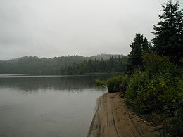
Beach at the mouth of Washington Creek


literature
- Johnson, David (November 9, 2009): North America's First Metal Miners & Metal Artisans. The Old Copper Complex. ( Online )
Individual evidence
- ↑ Distribution (PDF; 2.6 MB) on Michigan.gov