Longitude
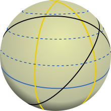
The longitudes are those great circles on an imaginary spherical surface of the earth , which run in north-south direction and go through both poles of rotation of the earth . Each longitude consists of two opposing meridians (semicircles) and is therefore characterized by specifying one of their geographical longitudes .
Longitude and meridian
So are z. B. on the longitude 13.5 ° East: Greifswald , Berlin , Passau and Spittal - as well as between the city of Pilsen in the Czech Republic, as in the north, the Swedish Karlstad and south Palermo on Sicily , Tripoli (Libya) and Luanda ( Angola ). If we extend the great circle to the other hemisphere ( i.e. look at the opposite meridian with geographical longitude 166.5 ° West), we come across Antarctica to the Cook Islands and Kiribati , and past Hawaii to the Aleutian Islands and the Bering Strait . The longitude 13.5 ° east is therefore identical to the longitude 166.5 ° west.
However, the difference between the longitude and meridian is often blurred in everyday geography . For astronomers , the meridian runs through a full 360 ° on the celestial sphere , but when they hear the word, they mainly think of its upper half. There the sun culminates every midday ( meridies = midday line ), while it passes through the lower arc at midnight.
Closer examination of the longitudes
The term longitude comes from mathematics , geography and astronomy in equal measure - where inclined longitudes are also used in relation to the ecliptic (apparent path of the sun) and even the Milky Way . But lunar maps also have their (selenographic) lengths, and in space travel to planets and for purposes of determining orbits , they often have to be laid out completely differently.
Longitudinal circles on the earth and other deformed spheres
If you take a closer look at the earth, you can no longer accept it as a sphere , but at least have to consider its flattening . The earth's shape is in fact by the daily rotation and its centrifugal force bulges at the equator and flatter in the polar regions as an equal ball. The difference in the radii is 21,387 meters (or 1: 298.24 of the mean equatorial radius of 6,378,137 meters).
On an ideal earth ellipsoid (which corresponds to the sea level or the geoid up to 100 meters ), the longitudes are ellipses , but at least all of the same length. On the other hand, on the mathematical earth figure of the geoid, they have a slightly unequal scale. In astrogeodesy , they are no longer defined as a smooth line, but rather by their common astronomical length . The irregularities (up to about 1 km to the right / left of the central meridian plane) come from local and regional features of the earth's body and can be modeled by gravity anomalies or deviations from the vertical.
These deviations between the geometric and physical definition on the giant planet Jupiter (jovigraphic longitude / latitude) and on Mars are around 10 times greater . Because of its small size (51% of the Earth's radius), the red planet is hardly flattened, but it is clearly triaxial .
The size of the earthly longitudes and latitudes
As stated above, the circles of longitude on the (idealized) earth are all of the same length, while the radius of the circles of latitude decreases with the cosine of the geographical latitude towards the poles ( r = R · cos B ).
Since all the longitudes of a sphere are great circles, they each divide the earth into two halves. They also do this on the (flattened) earth ellipsoid, although there they have the shape of ellipses.
The longitude circles (or longitude ellipses) have the bisecting property in common with the earth's equator , which, however, as the longest parallel on the actual earth, is 2 ‰ longer: It measures 40,075 km at sea level, whereas the longitude circles only 40,008 km.
Meter convention
When French scientists defined the meter towards the end of the 18th century , they planned to equate the circumference of the earth with 4 × 10 million meters. The difference of around 8 km to 40,000 km is due to inevitable small measurement errors and rusting standards of the two expeditions at that time ( Lapland and Peru ). There were two main reasons for not wanting to adjust the meter to the latitude but to the longitude :
- all parallels are of different lengths (see above), whereas the longitudes are the same length.
- The measurement of the geographical latitude - i.e. the earth survey in north-south direction - is still easier to carry out than over the geographical longitude in east-west direction.
The meter convention does not go back directly to the measurements in Lapland and Peru, but to the measurement of a section of the meridian quadrant (quarter of a great circle) that runs through Paris. The two astronomers Jean-Baptiste Joseph Delambre and Pierre Méchain measured the distance from Dunkirk to Barcelona (about 10 ° difference in latitude) using trigonometric means and determined the difference in latitude using astronomical means. After assumptions about the shape of the earth, which were determined in the measurements in Peru and Lapland (near the equator and north pole), the length of the entire quadrant could be calculated. This resulted in systematic measurement errors due to Méchain, which he suppressed out of pedantry. These errors ultimately led to the inaccurate definition of the meter standard.
See also
- Geographical latitude , turning circle (latitude)
- Time , sidereal time , time zone , position of the sun , solar radiation
- Meridian arc

