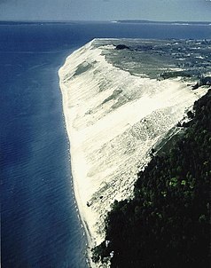
Sleeping Bear Dunes National Lakeshore
| Sleeping Bear Dunes National Lakeshore | ||
|---|---|---|
|
|
||
| Location: | Michigan , United States | |
| Next city: | Traverse City | |
| Surface: | 288 km² | |
| Founding: | October 21, 1970 | |
| Visitors: | 1,222,313 (2005) | |
Sleeping Bear Dunes is the name of a National Lakeshores on the east bank of Lake Michigan in the US state of Michigan .
The reserve is about 288 square kilometers and extends over 60 km along the northwest shore of the Lower Peninsula ( Lower Peninsula ) of Lake Michigan. The main attraction of the park are sand dunes, which tower over the shore up to 140 m high. From here you have a view of the lake, the offshore islands and the hinterland with Glen Lake . The two islands of North Manitou Island and South Manitou Island are also part of the reserve.
The landscape is shaped by the last ice age . The dunes themselves are around two thousand years old and are subject to constant change due to wind erosion. At Pierce Stocking Scenic Drive there is a lookout point right on the cliff. Not far from the western shore of Glen Lake are other accessible dunes, but they are not directly on Lake Michigan. The park is densely wooded, but the current tree population forms a secondary forest . The original primary forests were completely cleared in earlier times. Existing forests are converted into near-natural forests.
The name of the area goes back to an Anishinabe legend : once a she-bear with her two cubs fled from a forest fire into the water of the lake. The bears swam for their lives, but soon the cubs lagged behind their mother. Finally the bear reached the other bank and climbed a dune to look for her cubs, but they drowned. In time the wind covered the waiting mother with sand. The most striking point of the dunes, today largely eroded by wind erosion, is reminiscent of a sleeping or looking out bear. Under the sand, she should wait for the arrival of her young until today. Impressed by the fate and unshakable hope of the she-bear, the great Manitu created two islands at the point where the two young bears drowned. These are now called North and South Manitou Island. There is a small lake and camping facilities on both, and boats travel between the mainland and the islands. On the South Island there is a lighthouse, former coast guard stations and desolations .
Web links
- National Park Service: Sleeping Bear Dunes National Lakeshore (official site; English)


