
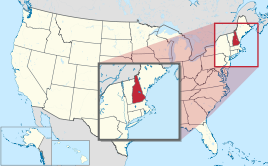
New Hampshire
| New Hampshire | |||||
|---|---|---|---|---|---|
| |||||
 .svg) | |||||
| Capital: | Concord | ||||
| State motto: | Live free or die (live free or die) | ||||
| Official language : | English | ||||
| Surface: | 24,216 km² | ||||
| Residents: | 1,334,795 (2016 estimated) (54 U / km²) | ||||
| Member since: | June 21, 1788 | ||||
| Time zone: | Eastern: UTC − 5 / −4 | ||||
| The highest point: | 1,917 m ( Mount Washington ) | ||||
| Average Height: | 305 m | ||||
| Deepest point: | 0 m Atlantic Ocean | ||||
| Governor : | Chris Sununu ( R ) | ||||
| Post / Office / ISO | NH / / US-NH | ||||
 | |||||


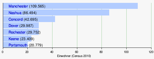
New Hampshire ( [ nuː ˈhæmpʃɚ ] AE / [njuː ˈhæmpʃə] BE ) is a United States state in the New England region . It is bordered by the state of Vermont to the west, Maine to the east, Massachusetts to the south and the Canadian province of Quebec to the north . With an area of 24,216 km², the state has around 1.3 million inhabitants. The majority of the population lives in the south of the state, the north is characterized by low mountain ranges. The capital is Concord with almost 43,000 inhabitants, but the largest city is Manchester with 110,000.
The first traces of human settlement go back over 10,000 years. The vast majority of the population is of European descent, and Indians have not been around since the 1740s. From the 1630s onwards, contacts with Europeans led to severe population losses among the indigenous peoples , mainly due to the smallpox epidemics . Finally, fighting with the Iroquois and the English drove the survivors to Maine and Canada .
Since 1629 England appeared as a colonial power , the colony was named after the English Hampshire . According to the principles of English feudalism , the land was assigned and settlers appointed. From 1641 to 1679 New Hampshire belonged to Massachusetts, was then under direct control of the king for two decades and came back to Massachusetts from 1691 to 1741, whose governors were responsible for the northern neighbor.
In 1776, New Hampshire became the first colony to form a government and constitution, and became independent with the newly formed United States. Concord became its capital in 1808. An independent republic existed on the Canadian border from 1832 to 1835; Great Britain did not give up its claims until 1836. The state benefited economically from industrialization and the civil war , but essential industries collapsed with the global economic crisis . Only the connection to the Boston economic area brought new branches of industry, especially to the south of New Hampshire.
The state is due to its quarries and The Granite State ( " Granite called -State"). At the same time, the nickname also reflects the preservation of traditions and the history of an economical government. There are no general VAT or income taxes , which corresponds to the state motto " Live or die free ".
geography
Location, extent and structure


New Hampshire is one of the New England states .
The most significant areas of New Hampshire are the Great North Woods , the White Mountains , the Lakes Region , the Seacoast Region , the Merrimack Valley , where most of the residents live Monadnock Region and the Dartmouth-Lake Sunapee Region .
The White Mountains are part of the Appalachian Mountains and cover the northern part of New Hampshire. The highest mountain in the range and the third largest of the Appalachians is Mount Washington with 1917 m. Apart from Alaska, Mount Washington is one of the coldest regions in the USA . If temperatures of over 0 ° C are still measured in the valley in autumn, it is often -40 ° C there.
In the rather flatter southwest of the state, the most prominent mountain is Mount Monadnock .
The most important rivers are the 177 km long Merrimack River , which flows through New Hampshire from north to south and on to Massachusetts . Its most important tributaries are the Contoocook River , the Pemigewasset River and the Winnipesaukee River , the 670 km long Connecticut River forms the western border with Vermont and flows further south through the states of Massachusetts and Connecticut . What is special is that the state border is not the middle of the Connecticut River, but that New Hampshire owns the entire river. The Piscataqua River flows into the Atlantic Ocean , there are several ports, including Portsmouth . New Hampshire has an ongoing border dispute with Maine over several islands (now known as Seavey Island), including the Portsmouth naval shipyard .
The largest lake is Lake Winnipesaukee with a size of 186 km² in the middle of New Hampshire.
landscape
In percentage terms, New Hampshire is the second most forested of the 50 US states after its eastern neighbor Maine .
Counties, cities, places, population distribution

The largest towns are:
history
Early history
Paleo-Indians
During the ice ages , the last of which is known as the Wisconsin Glaciation , hardly any people could live in the New Hampshire area. The area was only consistently from the 8th millennium BC. Inhabited, but the first humans came about three millennia earlier.
A systematic archaeological investigation of the national territory does not exist. Half of the 16 Paleo-Indian sites (as of 2012) were discovered by chance, the rest on the basis of investigations prior to construction work, and only one (Thorne) was discovered as a result of a targeted search for relevant sites. There are also 8 other artifacts from this earliest era of Indian settlement that are well documented. Paleo-Indian exploration in New Hampshire did not accelerate until 1995 with the discovery of several camps on the Israel River . Until then, the Whipple site above the Ashuelot River , discovered in the mid-1970s, was the only well-documented site, but it was badly damaged by souvenir hunters. It was suggested that before 10,000 to 11,000 radiocarbon years caribou and beaver hunters inhabited the region. They left behind a larger camp on the Israel River, which was probably used by several family associations, a quarrying and processing site for stones (another was found at Colebrook ) and several short-term stores. In Tamworth likewise found a small rhyolite -Abbaustätte. The Potter site at Randolph , discovered in 2003, covers 1.2 hectares and has at least eight high-density sections. Intensive wood processing took place on at least two of them. The site, which was used for a long time, contained two types of projectile points , namely the Michaud / Neponset (middle Paleo-Indian, sometimes very long points) and the Bull Brooke / West Athens Hill type; In Auburn , fluted points were found, which were used to fix the shaft, in the Kings Road / Whipple style. Even the sometimes long known were hand axes re-examined. The sites are occasionally over an acre ( Potter , Jefferson III ), but the smallest is only 25 m². This is the Colebrook site , where 3,200 tees were found. Here a group of hunters were preparing their weapons for an upcoming hunt. Archeology says goodbye to the widespread notion that the paleo-Indians, in contrast to the archaic Indians, lived mainly from the megafauna . It is only clear that with the disappearance of mammoths and mastodons in particular , specialization began in smaller animals that occur in large herds , such as caribou and bison .
The rhyolite from Mount Jasper in Berlin is related to finds in Massachusetts ( Neponset site ) and Maine . So far no slaughterhouses ("kill sites"), graves or ritual sites have been discovered, only large camps and small hunting camps , as well as stone quarrying and processing sites . The most important stone quarrying site is Mount Jasper, which was entered on the National Register of Historic Places . The rhyolite on the Israel River is similar to that on Mount Jasper, but it does not come from the mountain, but from an unknown source. In contrast, Stone's Throw artifacts come from Mount Jasper. The neighboring northern slope of the Ossipee Mountains in Tamworth was of similar importance for the provision of the basic material . There was a rock known as Ossipee hornfels that contains large amounts of flint - it was found next to the rhyolite from Mt. Jasper in Stone's Throw , but from the post-Paleo-Indian archaic period . Approximately 15 km to the southeast, at the Thornton site , raw hand axes made from this material, which is more like an andesite , a volcanic rock, were found. Something similar was found 60 km north at the Porter site .
The Whipple site is one of the most important sites in the northeastern United States, and it also provided radiocarbon data. As in the case of the Porter site and Jefferson II on the Israel River, it was a "base camp" that was used repeatedly over a long period of time. These camps were preferably set up on the edge of wetlands near lakes, especially dead ponds .
Archaic period
Finds from the archaic period , especially tool remains made of quartz , could be dated to around 9000 BP . Archaeological excavations have shown the mining of rocks that were used for tools and weapons. North of Lake Winnipesaukee , Hornfels deposits were already mined in late Archaic times. One of the reasons for the early use of the lake was, next to the Hornfels, in a store of rhyolite , a rock from which tools were made in workshops that were found near Belmont (NH 31-20-5). In two workshop centers different preforms, so-called cores or cores for scrapers , scrapers , drills and blades were made , which were mainly produced between 6000 and 5000 BC. BC originated. A total of around 30,000 artifacts were found . Hides and wood were also worked there, so that they were probably permanently inhabited villages. In 1999 similar workshops were discovered at Silver Lake . These workshops supplied the area with finished tools, such as the Merrimack Valley.
Another important site, an emergency excavation site on the west bank of Lake Winnipesaukee, is in the Lochmere Archaeological District . The Lodge Site (NH31-6-6) spans the Middle Archaic period and extends into the late woodland period . In addition to tools, 145 pieces of pottery were found from the younger woodland period , which is characterized by the cultivation of land and the manufacture of clay vessels.
Western Abenaki, Mohawk

The western Abenaki lived in what is now New Hampshire and Vermont as well as in the adjacent areas of the colony of New France at the beginning of the 17th century . They lived in the Lake Champlain Valley , the Green Mountains , the Connecticut Valley, and the White Mountains , the adjacent highlands of which cut the valleys of Lake Winnipesaukee and the Merrimac River to the south .
Abundant rainfall, very cold and long winters made soil cultivation, such as the cultivation of pumpkins, difficult. Hunting and fishing were therefore the main sources of food. Maple trees provided syrup and sugar, the lake fish. For this purpose, the men set up pots, traps, fishing rods and nets. Field work and gardening were women's work, apart from tobacco. The women gathered wild berries, especially blueberries . In the mixed forest area, which is rich in game, there were not only deciduous trees but also hemlocks and white pines , on the mountains and mountain slopes predominantly northern deciduous trees and red firs , in the swamp areas balsam spruce , black spruce , larch and white cedar . On large mammals, the Abenaki hunted moose, deer and black bears, but also hares, weasels, squirrels and birds; For the fur trade they also hunted beavers, muskrats , otters, mink , fishing marten , raccoons , foxes and skunks , hunting with snowshoes and sledges in winter . They were not in competition with wolves and bobcats .
The Penacook , who lived further south between Concord and Manchester, enjoyed a milder climate. They grew corn , beans, and pumpkins. They were the first to come into contact with the European colonists. In this early phase of European settlement, the Penacook belonged to a large confederation named after them. It served to repel the Mi'kmaq in the north and the Mohawk in the west. Their center was around Concord, there they built three forts around 1600, but they could not stop the Mohawk. A considerable proportion of the tribe fell victim to them, so that some authors spoke of the "destruction" of the tribe. The 1617 epidemic, which raged from the Saco River to Cape Cod, struck all tribes along the coast. Whether it has already reached the Concord area can only be assumed. At least 17 Penacook village groups are known, but a myriad of assumptions and contradictions appear in the literature. Cook (p. 16) assumes at least 2500 Penacooks who lived on the Merrimac around 1600. On Lake Winnepesaukee, to which the tribe of the same name gave its name, there were nine villages, seven of them in the southwest, probably with at least 1500 inhabitants. Perhaps the only large Coosuck village in the sparsely populated north stood around Newbury.
An epidemic of smallpox struck the New England tribes in 1633 and 1634. It spread north to the Abenaki and St. Lawrence tribes and eventually to the Iroquois . Around 1637, the Abenaki received their first rifles from English traders, who in 1638 established a trading post on the Merrimack River with the Pennacook. In 1642 the Western Abenaki allied themselves with the Mahican and their earlier enemies, the Mohawk, against the Montagnais or Innu of the north. Although the Jesuits succeeded in achieving peace between eastern Abenaki and Innu, conflicts arose with the Mohawk in the west. The Pocumtuc left the Connecticut Valley in Massachusetts and moved north, leaving only Missisquoi and Cowasuck in Vermont as the last major villages of the Western Abenaki. In 1668 the Mohawk drove the Pennacook through New Hampshire into southern Maine .
British colonial rule
First English settlements

In 1629 the Council for New England or the English King Charles I awarded Gorges land in the New World to Captain John Mason and Sir Ferdinando . The colony was named New Hampshire after the English Hampshire , whose name in turn went back to Southampton or Hampton.
The first settlement arose at Odiorne's Point near what is now Portsmouth , where Odiorne Point State Park now extends. A group of fishermen worked under the leadership of David Thompson, also known as Thomson. Thompson's father worked for Sir Ferdinando Gorges of Plymouth, who had received the right from King James I in 1623 to establish plantations at Jamestown and Plymouth. Thompson's settlers built a fort, mansion, and several cottages on Flake Hill in 1623, three days after the Pilgrim Fathers landed in Plymouth . The settlement was named Pannaway Plantation.
David Thompson was sent by Mason, followed a few years later by Edward and William Hilton. Their expedition reached Dover, which they called Northam. Mason, who died in 1635, never saw his colony. Pannaway settlers later moved to the Portsmouth region, where they met the expedition of the Laconia Company , founded in 1629, under Captain Neal. They named their settlement Strawbery Banke . In 1638 Exeter was founded by John Wheelwright .
As early as 1631, Captain Thomas Wiggin was named the first governor of the Upper Plantation, which included Dover, Durham and Stratham .
Joined Massachusetts (1641–1679)
Although the small colonies agreed to amalgamate in 1639, Massachusetts filed claims to the territory. In 1641 the colony came under his jurisdiction , but Boston left them a certain self-government (home rule). In 1653, Strawbery Banke applied to the General Court of Massachusetts to change his name to Portsmouth.
Royal Province (1679–1691), part of Massachusetts (1691–1741)
In 1679, Charles II separated New Hampshire from Massachusetts and raised the former to the royal province of New Hampshire. The first governor was John Cutt . New Hampshire belonged to the Dominion of New England from 1686, which however dissolved again in 1689. After a brief period of governmentlessness in which Massachusetts took over external affairs, "William and Mary," by which one meant the rulers William of Orange and Mary II , issued a new charter in 1691 . From 1699 to 1741, the governors of Massachusetts were also responsible for New Hampshire.
Involvement in colonial wars, disappearance of the Indians, end of the expansion to the west
-New_Hampshire-29_Apr_1780_OBV.jpg)
The alliance between the English and the Iroquois had forced the Abenaki on the side of the French and their allies. When chief Metacomet or "King Philip" attacked the English colonies in 1675 , most Abenaki were neutral, but at least the southern groups supported him, which were most affected by English settlement pressure and land grabbing. The English responded with a punitive expedition, and even the Penobscot and Kennebec , who lived further north, were drawn into the war, which turned into a massacre. After 1676 there were only about 4,000 Indians left in southern New England, and the number of adult men in the Merrimack area had collapsed from several thousand to about 300. Many Abenaki had fled to French territory. The fighting between France and England was so ruthless that in 1695 the entire border area was depopulated. A peace agreement was not reached until 1727.
By 1680, smallpox had decimated the number of Pemigewasset so far that they settled above Plymouth . One of their main camp was on the profile falls at Smith River , another on the old highway from Bristol to Hill . At Bristol, the Pemigewasset and Pass-aqua-nik trails met the Mascoma trail, which followed the Smith River. The Kancamagus Trail merged with the Pemigewasset trail at Woodstock , and the Asquamchumaukee Trail joined it where their old village had stood at the mouth of the Baker River , just above Plymouth .
In 1696 the few remaining families on Lake Winnipesaukee left their village Aquadoctan, accompanied by two young English prisoners. They joined the tribe of the Pequaket on the Saco River near what is now Fryeburg (in Oxford County of the state of Maine). By 1740 the province was practically depopulated of all indigenous groups.
In the 1730s, Lieutenant Governor John Wentworth succeeded in raising border disputes in London , while Massachusetts Governor Jonathan Belcher continued to give land to settlers in the disputed areas. In 1741 King George II set the current border and also separated the governorship. Benning Wentworth became the first non-Massachusetts governor of New Hampshire since Edward Cranfield . For his part, Wentworth awarded land further west, which, however, also claimed the province of New York. In 1777 Vermont declared itself an independent republic (in the first six months still as "New Connecticut", from July on as "Vermont"), the first Vermont constitution was passed and ratified .
Uprising against Great Britain, affiliation with the USA

New Hampshire was one of the Thirteen Colonies that rose against British colonial rule. In January 1776, New Hampshire became the first colony to form a government and a constitution, but unlike Rhode Island , which was the first to declare its independence, New Hampshire did not want to shake off the rule of London. The attack on today's Fort Constitution (then Fort William and Mary) brought ammunition for the battle on Bunker Hill , which took place a little later north of Boston. New Hampshire provided three regiments for the Continental Army . The New Hampshire Militia also fought at Bunker Hill, Bennington, the Saratoga Campaign and the Battle of Rhode Island . In 1788, New Hampshire was admitted to the United States as one of the 13 founding states.
US state
In 1808, Concord became the state capital.
Border disputes, slave liberation, land dispute (1815–1860)

In the 1830s the border question with Canada, which had remained British, was still not settled. Thus, from 1832 to 1835, the Republic of Indian Stream was created on the border. The New Hampshire militia occupied the area in 1835, with Great Britain not relinquishing its claims until January 1836. It was not until the Webster-Ashburton Treaty in 1842 that the border was regulated and the area was assigned to New Hampshire.
Abolitionists, advocates of the liberation of slaves from Dartmouth College advocated education for blacks, and in 1835 founded Noyes Academy in Canaan , accessible to whites and blacks alike ; but after a few months the local opponents pulled the school building away with oxen before they let it go up in flames.
Even if the abolitionist Free Soil Party, led by John P. Hale, found many supporters, Jackson’s Democratic supporters remained in the majority. They were run by editor Isaac Hill , who believed their land distribution plans were only in their own interests. In 1856 the Free Soil Party merged with the Republican Party .
Civil War (1861-1865)
New Hampshire contributed 18 regiments of infantry to the Civil War, as well as two regiments of cavalry, three companies of artillery and three companies of snipers. Of the 1,051 men of the 5th Infantry Division who were mustered in October 1861, only 477 returned.
Industrialization, global economic crisis, World War II, post-war period
The southern textile competition troubled New Hampshire. In 1935 the Amoskeag Manufacturing Company in Manchester was closed. In 1949 the Nashua Manufacturing Company in Nashua followed and the Brown Company's paper mill in Berlin went bankrupt . Improvements in the infrastructure, during this time mainly road construction, led to a stronger connection to Boston's industrial region. In the south of the state, the weapons electronics supplier Sanders Associates settled in 1952; The Digital Equipment Corporation followed in the early 1970s .
population
| Population development | |||
|---|---|---|---|
| Census | Residents | ± in% | |
| 1790 | 141,885 | - | |
| 1800 | 183,858 | 29.6% | |
| 1810 | 214,460 | 16.6% | |
| 1820 | 244.155 | 13.8% | |
| 1830 | 269,328 | 10.3% | |
| 1840 | 284,574 | 5.7% | |
| 1850 | 317.976 | 11.7% | |
| 1860 | 326.073 | 2.5% | |
| 1870 | 318,300 | -2.4% | |
| 1880 | 346.991 | 9% | |
| 1890 | 376,530 | 8.5% | |
| 1900 | 411,588 | 9.3% | |
| 1910 | 430,572 | 4.6% | |
| 1920 | 443.083 | 2.9% | |
| 1930 | 465.293 | 5% | |
| 1940 | 491,524 | 5.6% | |
| 1950 | 533.242 | 8.5% | |
| 1960 | 606.921 | 13.8% | |
| 1970 | 737.681 | 21.5% | |
| 1980 | 920.610 | 24.8% | |
| 1990 | 1,109,252 | 20.5% | |
| 2000 | 1,235,786 | 11.4% | |
| 2010 | 1,316,470 | 6.5% | |
| Before 1900
1900-1990 2000 |
|||

Religions
Almost 80% of the population professes Christianity. The largest Christian religious community is the Catholic Church - 35% of Christians are Catholics, mostly of French and Irish origin. The two main Protestant religious communities are the United Church of Christ with 34,299 and the United Methodist Church with 18,927 members.
Around 18% describe themselves as non-religious or atheists, while other religious communities (Jews, Buddhists, Muslims) together make up 2% of the population.
Demographics
In 2010, 92.3% of the population were White (excluding Hispanic-Americans), 2.2% Asian, 1.1% African-American, and 0.2% Native American. 2.8% were Latinos (Hispanic Americans). In 2014, 23.6% had French or Franco-Canadian, 20.9% Irish, 17.1% English, 10.8% Italian and 9.4% German ancestors. 6% of the population were born outside of the United States. The French-Canadian or French-born population and the Irish-born mainly live in traditional mining towns like Manchester.
politics
The state of New Hampshire, traditionally the most conservative in New England, has been classified as the swing state since the 1990s . Although traditionally Republican -oriented, chose New Hampshire in 1992 for the first time since Lyndon B. Johnson's landslide victory of 1964 again democratically . Since then, the state and its four electoral votes have been hotly contested between the two parties until election day. In November 2008, New Hampshire became the first state in its Senate to have a female majority. Thirteen out of 24 MPs were women after that election (down from 1 in 4 the US average). In Congress New Hampshire is represented by four women from January 2017: Jeanne Shaheen (Democrat) and Maggie Hassan (Democrat) in the Senate , Carol Shea-Porter (Democrat) and Ann McLane Kuster (Democrat) in the House of Representatives . Republican Chris Sununu has been the state governor since January 2017.
On June 3, 2009, New Hampshire became the sixth state in the United States to open marriage to same-sex couples.
| year | republican | Democrats |
|---|---|---|
| 2016 | 46.61% 345.790 | 46.98% 348,526 |
| 2012 | 46.40% 329,918 | 51.98% 369,561 |
| 2008 | 44.52% 316,534 | 54.13% 384,826 |
| 2004 | 48.87% 331,237 | 50.24% 340, 511 |
| 2000 | 48.07% 273,559 | 46.80% 266,348 |
Governors
senate
House of Representatives
Abolition of the death penalty
In 2019 - against the will of Governor Chris Sununu - the death penalty was abolished. New Hampshire was one of two US states (the other is Kansas) that reintroduced the death penalty after 1976 but have not used it since (the last execution in New Hampshire took place in 1939).
Economy and Infrastructure
The real gross domestic product per capita GDP - the most important indicator of prosperity - was USD 58,327 in 2016 (national average of the 50 US states: USD 57,118; national ranking: 18). The unemployment rate was 2.9% in November 2017 (national average: 4.1%).
Important products used to be shoes and textiles, but granite mining has remained. Agriculture (dairy, poultry), electrical, paper and pulp industries are important.
The state does not collect sales or income taxes (other than a 5% levy on dividends and interest). This resulted in high property taxes being paid in New Hampshire. The state has small taxes on meals, lodging, vehicles, and road tolls.
traffic
Streets
According to the National Highway Traffic Safety Administration, New Hampshire is the only US state in which there is no general seat belt requirement for adults. Only children and young people under the age of 18 have to wear seat belts when driving. Regardless of this, in 2008, 69% percent of road users used their seat belts while driving; the national average over the same period was 83%. After a move by the Democratic Senator Maggie Hassan in 2007, the introduction of a general seat belt requirement was discussed again in April 2009 and a corresponding bill was submitted, which, however, met with resistance, especially from Republican MPs, which in it contradicted the state motto of New Hampshire (“Live free or die “) saw.
railroad
The first railroad in the state was opened on December 23, 1838 by the Nashua and Lowell Railroad . In the following years, various railway companies opened up mainly the south of the country. The capital Concord was reached on September 7, 1842.
Due to the geographical division of the country by the White Mountains, there were initially two independent networks. In the north, the Atlantic and St. Lawrence Railroad, completed in 1853, crossed the state. This line was initially built with a gauge of 1676 mm, but was re-gauged until 1873 in order to save the costs of reloading the goods. The two networks were not connected to each other until 1872 by the White Mountains Railroad . In the 1870s, the Portland and Ogdensburg Railway , the second east-west connection in the north, went into operation.
The country's only narrow-gauge railroad, the Profile and Franconia Notch Railroad , ran in the White Mountains from 1879 to about 1930. Another special feature is the Mount Washington Cog Railway , the oldest cog railway in the world, which has been leading up to the highest mountain in the state, Mount Washington , since 1869 .
Today, the New Hampshire railroad network consists of four disconnected parts. The three most important north-south main routes, Boston – Portland, Boston – Concord and Springfield – White River Junction are served by Pan Am Railways , the first and third of the routes also by Amtrak in passenger transport. In the north, the St. Lawrence and Atlantic Railroad operates the main line Portland – Montreal, which crosses the state in an east-west direction. In addition, local railway companies and some museum railways operate other routes.
education
The main state university is the University of New Hampshire . The best-known private university is the Ivy League scoring Dartmouth College . Additional colleges can be found on the New Hampshire List of Universities .
literature
- David R. Starbuck: The Archeology of New Hampshire. Exploring 10,000 years in the Granite State , University of New Hampshire Press 2006.
- Tadeusz Piotrowski: The Indian Heritage of New Hampshire and Northern New England , McFarland, Jefferson ( North Carolina ) 2002.
- Eric A. Masterson: Birdwatching in New Hampshire , University Press of New England 2013.
Web links
- Official website of the state of New Hampshire . Retrieved April 26, 2019.
- Literature about New Hampshire in the catalog of the German National Library
- Visit New Hampshire (tourist information) (English / partly with German translation)
- Free State Project (English)
Individual evidence
- ^ Concord city, New Hampshire, 2013-2017 American Community Survey 5-Year Estimates. In: US Census Bureau . 2018, accessed on March 11, 2019 .
- ↑ This and the following from: Richard Boisvert: The Paleoindian Period in New Hampshire , in: Claude Chapdelaine (Ed.): Late Pleistocene Archeology and Ecology in the Far Northeast , Texas University Press 2012, pp. 77-94.
- ↑ These are: Colebrook site, Mount Jasper lithic source ( Berlin ), Israel River Complex IV, Potter site (Randolph (Massachusetts) | Randolph), Stone's Throne site ( Tamworth ), Thorne site ( Effingham ), Weirs Beach site ( Laconia ) , George's Mill ( Sunapee ), Whipple site ( Swanzey ), Tenant Swamp site ( Keene ), Thornton's Ferry and Hume sites ( Merrimack ). A third of the sites also show significantly later layers .
- ↑ Similar camps are the Bull Brooke site in northeast Massachusetts and the Vail site in western Maine .
- ^ Kurt W. Carr, JM Adovasio: Shades of Gray Redux. The Paleoindian / Early Archaic "Transition" in the Northeast , in: C. Britt Bousman, Bradley J. Vierra (Eds.): From the Pleistocene to the Holocene. Human Organization and Cultural Transformations in Prehistoric North America , Texas University Press 2012, pp. 273-317, here: p. 289.
- ↑ This and the following from: David R. Starbuck: The Archeology of New Hampshire. Exploring 10,000 Years in the Granite State , University of New Hampshire Press 2006.
- ^ David R. Starbuck: The Archeology of New Hampshire. Exploring 10,000 Years in the Granite State , University of New Hampshire Press 2006, p. 65.
- ↑ Sherburne F. Cook: The Indian Population of New England in the Seventeenth Century , University of California Press 1997, p. 13.
- ↑ Sherburne F. Cook: The Indian Population of New England in the Seventeenth Century , University of California Press 1997, p. 15 ff. Discusses the individual groups, which he calls villages or "tribelets".
- ↑ James Lyford: History of Concord, NH, The Rumford Press 1903, pp. 324-326.
- ^ US Census Bureau _ Census of Population and Housing . Retrieved February 28, 2011
- ↑ Extract from Census.gov . Retrieved February 28, 2011
- ↑ Excerpt from factfinder.census.gov.Retrieved February 28, 2011
- ^ The Association of Religion Data Archives | Maps & Reports
- ↑ US Census Bureau
- ↑ American Community Survey 2014
- ↑ 270toWin!
- ^ New Hampshire Becomes First State Senate with Female Majority
- ↑ Larry Wayne Koch, Colin Wark, John F. Galliher: The Death of the American Death Penalty: States Still Leading the Way. Northeastern University Press, Lebanon 2012, ISBN 978-1-55553-782-1 , p. 89.
- ^ US Department of Commerce, BEA, Bureau of Economic Analysis: Bureau of Economic Analysis. Retrieved August 27, 2017 (American English).
- ^ Unemployment Rates for States. Retrieved January 8, 2018 .
- ^ The Tax Foundation. August 7, 2008, accessed January 8, 2018 .
States:
Alabama |
Alaska |
Arizona |
Arkansas |
Colorado |
Connecticut |
Delaware |
Florida |
Georgia |
Hawaii |
Idaho |
Illinois |
Indiana |
Iowa |
California |
Kansas |
Kentucky |
Louisiana |
Maine |
Maryland |
Massachusetts |
Michigan |
Minnesota |
Mississippi |
Missouri |
Montana |
Nebraska |
Nevada |
New Hampshire |
New Jersey |
New Mexico |
New York |
North Carolina |
North Dakota |
Ohio |
Oklahoma |
Oregon |
Pennsylvania |
Rhode Island |
South Carolina |
South Dakota |
Tennessee |
Texas |
Utah |
Vermont |
Virginia |
Washington |
West Virginia |
Wisconsin |
Wyoming
Federal District:
Washington, DC
External Areas:
American Samoa |
American Virgin Islands |
Baker Island |
Guam |
Howland Island |
Jarvis Island |
Johnston Atoll |
Kingman attack |
Midway Islands |
Navassa |
Northern Mariana Islands |
Palmyra Atoll |
Puerto Rico |
Wake up
Coordinates: 44 ° 0 ′ N , 71 ° 30 ′ W