Coös County, New Hampshire
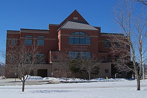
 Coös County Courthouse |
|
| administration | |
|---|---|
| US state : | New Hampshire |
| Administrative headquarters : | Lancaster |
| Foundation : | 1803 |
| Made up from: | Grafton County |
| Demographics | |
| Residents : | 33,055 (2010) |
| Population density : | 7.1 inhabitants / km 2 |
| geography | |
| Total area : | 4743 km² |
| Water surface : | 80 km² |
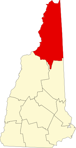
| map | |
Coös County (/ ˈkoʊ.ɒs /, with two syllables) is a county in the state of New Hampshire in the United States . The name is mostly written Coos . It has 33,055 inhabitants (as of 2010) and is thus by far the least populous County of New Hampshire, but has the largest area. 16.17 percent of the population speak French as their mother tongue. The county seat is Lancaster . The most important branches of the economy are agriculture and tourism .
history
Coös County was formed in 1803 from the northern part of Grafton County . At first Berlin was the seat of the county, later it became Lancaster.
One place in the county has the status of a National Historic Landmark , the Mount Washington Hotel . A total of 26 buildings and sites in the county are registered on the National Register of Historic Places (as of February 15, 2018).
Population development
| year | 1767 | 1773 | 1775 | 1783 | 1786 | 1790 | ||||
|---|---|---|---|---|---|---|---|---|---|---|
| Residents | 0 | 185 | 177 | 192 | 102 | 695 | ||||
| year | 1800 | 1810 | 1820 | 1830 | 1840 | 1850 | 1860 | 1870 | 1880 | 1890 |
| Residents | 1707 | 3015 | 4216 | 7010 | 8399 | 10,312 | 12,946 | 14,726 | 18,330 | 23,211 |
| year | 1900 | 1910 | 1920 | 1930 | 1940 | 1950 | 1960 | 1970 | 1980 | 1990 |
| Residents | 29,468 | 30,659 | 36.093 | 38,959 | 39,274 | 35,932 | 37,140 | 34,291 | 35,147 | 34,828 |
| year | 2000 | 2010 | 2020 | 2030 | 2040 | 2050 | 2060 | 2070 | 2080 | 2090 |
| Residents | 33.111 | 33,055 |
Note: The information for the time before the county was founded in 1803 represents the sums of the population of the later towns and is listed here for better tracking of the development of the settlement.
geography
The county has a total area of 4,743 square kilometers; 80 square kilometers (1.7 percent) of this is water.
Neighbor Counties
Coös County is bordered by the following other counties:
- Oxford County (Maine) , east
- Carroll County , Southeast
- Grafton County , Southwest
- Essex County, Vermont , west
- Estrie Administrative Region , Quebec , Canada
cities and communes
Coös County is divided into a city and 19 towns . There are also 23 unincorporated areas .
Due to the history of the county's settlement, the date of foundation in the list is not always to be equated with the beginning of the settlement. In many cases, parts of the towns were already settled before an official sale (grant) or a proclamation as part of the New Hampshire administration (Incorporation) took place. As a result, not all of the data is preserved.
| Locality | status | Population (2010) |
Total area [km²] |
Land area [km²] |
Population density [inhabitants / km²] |
founding |
|---|---|---|---|---|---|---|
| Berlin | City | 10.051 | 161.8 | 159.6 | 63.0 | 1771 |
| Carroll | town | 763 | 130.0 | 129.9 | 5.9 | 1772 |
| Clarksville | town | 265 | 161.2 | 155.7 | 1.7 | 1854 |
| Colebrook | town | 2,301 | 105.9 | 105.4 | 21.8 | Dec. 1, 1790 |
| Columbia | town | 757 | 156.9 | 156.1 | 4.8 | Dec. 1, 1770 |
| Dalton | town | 979 | 72.6 | 71.2 | 13.7 | Nov 4, 1784 |
| Dumber | town | 304 | 128.0 | 124.9 | 2.4 | March 8 1773 |
| Errol | town | 291 | 180.6 | 157.0 | 1.9 | Feb. 28, 1774 |
| Gorham | town | 2,848 | 83.7 | 82.4 | 34.6 | |
| Jefferson | town | 1.107 | 130.6 | 129.7 | 8.5 | Feb. 26, 1775 |
|
Lancaster ( County Seat ) |
town | 3,507 | 131.4 | 129.1 | 27.2 | July 5, 1763 |
| Milan | town | 1,337 | 167.2 | 165.2 | 8.1 | Dec 31, 1771 |
| Northumberland | town | 2,288 | 94.5 | 92.5 | 24.7 | Nov 16, 1779 |
| Pittsburg | town | 869 | 754.1 | 728.7 | 1.2 | |
| Randolph | town | 310 | 122.1 | 122.0 | 2.5 | Aug 20, 1772 |
| Shelburne | town | 372 | 126.4 | 124.2 | 3.0 | Dec 13, 1820 |
| Strong | town | 556 | 154.3 | 152.0 | 4.6 | Dec 28, 1832 |
| Stewartstown | town | 1.004 | 121.2 | 119.7 | 8.4 | Dec 1799 |
| Stratford | town | 746 | 207.2 | 205.8 | 3.6 | Nov 16, 1779 |
| Whitefield | town | 2,306 | 92.3 | 88.6 | 26.0 | 4th July 1774 |
Unregulated areas
| Locality | Population (2010) |
Total area [km²] |
Land area [km²] |
Population density [inhabitants / km²] |
|---|---|---|---|---|
| Atkinson and Gilmanton Academy grant | 0 | 50.6 | 50.3 | 0.0 |
| Beans grant | 0 | 25.1 | 25.1 | 0.0 |
| Beans purchase | 0 | 169.0 | 168.7 | 0.0 |
| Cambridge township | 8th | 132.4 | 130.5 | 0.1 |
| Chandlers purchase | 0 | 5.5 | 5.5 | 0.0 |
| Crawford's purchase | 0 | 21.2 | 21.2 | 0.0 |
| Cutts grant | 0 | 29.6 | 29.6 | 0.0 |
| Dixs grant | 1 | 52.3 | 52.2 | 0.0 |
| Dixville township | 12 | 126.9 | 126.4 | 0.1 |
| Ervings location | 0 | 9.5 | 9.5 | 0.0 |
| Greens grant | 1 | 9.5 | 9.5 | 0.1 |
| Hadley's purchase | 0 | 19.2 | 19.2 | 0.0 |
| Kilkenny township | 0 | 66.4 | 66.4 | 0.0 |
| Low and Burbanks grant | 0 | 67.7 | 67.7 | 0.0 |
| Martin's location | 0 | 9.7 | 9.7 | 0.0 |
| Millsfield township | 23 | 117.0 | 115.9 | 0.2 |
| Odell township | 73 | 117.0 | 115.2 | 0.6 |
| Pinkhams grant | 9 | 9.8 | 9.8 | 0.9 |
| Sargents purchase | 3 | 66.9 | 66.9 | 0.0 |
| Second college grant | 0 | 107.9 | 106.6 | 0.0 |
| Success township | 0 | 147.7 | 146.3 | 0.0 |
| Thompson and Meserves purchase | 0 | 47.9 | 47.9 | 0.0 |
| Wentworth location | 33 | 50.3 | 48.0 | 0.7 |
literature
- John Farmer & Jacob B. Moore: A Gazetteer of the state of New-Hampshire . Concord 1823 ( limited preview in Google Book search).
- Edwin A. Charlton: New Hampshire as it is . Tracy and Sandford, Claremont, NH 1855 ( limited preview in Google Book search).
Web links
Individual evidence
- ↑ GNIS-ID: 873177. Retrieved on February 22, 2011 (English).
- ↑ according to 2010 Census, American Fact Finder
- ↑ Listing of National Historic Landmarks by State: New Hampshire . National Park Service , accessed February 15, 2018.
- ↑ Search mask database in the National Register Information System. National Park Service , accessed February 15, 2018.
- ^ Population prior to 1790 by local census ( from the New Hampshire state website ), 1790-2010 by US census results
Coordinates: 44 ° 41 ′ N , 71 ° 18 ′ W
