Merrimack County
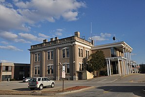
 Merrimack County Courthouse |
|
| administration | |
|---|---|
| US state : | New Hampshire |
| Administrative headquarters : | Concord |
| Foundation : | 1823 |
| Demographics | |
| Residents : | 146,445 (2010) |
| Population density : | 60.5 inhabitants / km 2 |
| geography | |
| Total area : | 2477 km² |
| Water surface : | 57 km² |
| map | |
| Website : www.merrimackcounty.net | |
Merrimack County is a county in the state of New Hampshire in the United States . 136,225 people live here. The county seat is Concord , the capital of New Hampshire.
history
Merrimack County has been organized in Concord since 1823 and named after the Merrimack River. It was formed from the respective northern parts of Hillsborough County and Rockingham County .
Two places in the county have National Historic Landmark status , the Canterbury Shaker Village and the Daniel Webster Family Home . A total of 88 buildings and sites in the county are listed on the National Register of Historic Places (as of February 15, 2018).
| year | 1980 | 1990 | 2000 | 2010 |
|---|---|---|---|---|
| Residents | 98.038 | 120.005 | 136.225 | 146,445 |
geography
The county covers an area of 2,477 square kilometers. Of this, 57 square kilometers (3.1 percent) are water surfaces.
- Neighbor counties
- Belknap County , Northeast
- Strafford County , East
- Rockingham County , southeast
- Hillsborough County , south
- Sullivan County , west
- Grafton County , Northwest
cities and communes
Merrimack County is divided into two Cities and 25 Towns ; both terms are translated into German as city . The numbers behind the place names are the population figures from the 2010 census.
Cities
Towns
|
|
|
Web links
Individual evidence
- ↑ GNIS-ID: 873180. Accessed on February 22, 2011 (English).
- ↑ Listing of National Historic Landmarks by State: New Hampshire . National Park Service , accessed February 15, 2018.
- ↑ Search mask database in the National Register Information System. National Park Service , accessed February 15, 2018.
- ↑ American FactFinder , accessed April 19, 2018
Coordinates: 43 ° 18 ′ N , 71 ° 41 ′ W
