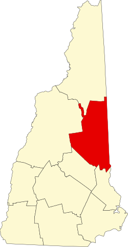
Carroll County, New Hampshire
 Carroll County Courthouse |
|
| administration | |
|---|---|
| US state : | New Hampshire |
| Administrative headquarters : | Ossipee |
| Foundation : | December 2, 1840 |
| Demographics | |
| Residents : | 47,818 (2010) |
| Population density : | 19.8 inhabitants / km 2 |
| geography | |
| Total area : | 2570 km² |
| Water surface : | 151 km² |
| map | |
Carroll County is a county in the state of New Hampshire in the United States . In 2010, 47,818 people lived here. The county seat is Ossipee .
geography
The county has an area of 2570 square kilometers. 151 square kilometers (5.89 percent) of this is water.
- Neighboring counties
- Coos County, New Hampshire , north
- Oxford County, Maine , Northeast
- York County, Maine , southeast
- Strafford County ( New Hampshire ), South
- Belknap County ( New Hampshire ), Southwest
- Grafton County ( New Hampshire ), West
history
Carroll County was formed from the northern parts of Strafford County in 1840 and named after Charles Carroll , a signer of the American Declaration of Independence from Maryland .
One place in the county has the status of a National Historic Landmark , the EE Cummings House . A total of 47 buildings and sites in the county are registered on the National Register of Historic Places (as of February 15, 2018).
Population development
| year | 1767 | 1773 | 1775 | 1783 | 1786 | 1790 | ||||
|---|---|---|---|---|---|---|---|---|---|---|
| Residents | 0 | 1194 | 1581 | 1172 | 2180 | 4812 | ||||
| year | 1800 | 1810 | 1820 | 1830 | 1840 | 1850 | 1860 | 1870 | 1880 | 1890 |
| Residents | 9230 | 13.199 | 17,561 | 19,978 | 21.307 | 21,507 | 20,465 | 17,328 | 18,224 | 18,124 |
| year | 1900 | 1910 | 1920 | 1930 | 1940 | 1950 | 1960 | 1970 | 1980 | 1990 |
| Residents | 16,895 | 16,316 | 15,017 | 22,623 | 24,328 | 26,632 | 28,912 | 32,367 | 27,931 | 35,410 |
| year | 2000 | 2010 | 2020 | 2030 | 2040 | 2050 | 2060 | 2070 | 2080 | 2090 |
| Residents | 43,666 | 47,818 |
Note: The information for the time before the county was founded in 1840 represents the sums of the population of the later towns and is listed here for better tracking of settlement development.
Communities
In addition to the 18 towns listed below, Caroll County has an unrestricted area: Hale's Location, which had 120 residents in the 2010 census.
| Locality | status | Population (2010) |
Total area [km²] |
Land area [km²] |
Population density [inhabitants / km²] |
founding |
|---|---|---|---|---|---|---|
| Albany | town | 735 | 194.6 | 193.2 | 3.8 | 1766 |
| Bartlett | town | 2,788 | 195.0 | 193.9 | 14.4 | 1790 |
| Brookfield | town | 712 | 60.2 | 59.1 | 12.0 | 1794 |
| Chatham | town | 337 | 148.5 | 147.1 | 2.3 | 1767 |
| Conway | town | 10.115 | 185.6 | 179.8 | 56.3 | 1760 |
| Eaton | town | 393 | 66.3 | 62.9 | 6.2 | Nov 7, 1766 |
| Effingham | town | 1,465 | 102.6 | 99.5 | 14.7 | 1749 |
| Freedom | town | 1,489 | 98.7 | 90.6 | 16.4 | 1831 |
| Hart's location | town | 41 | 48.1 | 47.9 | 0.9 | 1766 |
| Jackson | town | 816 | 173.4 | 173.3 | 4.7 | 1771 |
| Madison | town | 2,502 | 106.0 | 99.8 | 25.1 | 1852 |
| Moultonborough | town | 4,044 | 193.2 | 154.0 | 26.3 | 1763 |
|
Ossipee ( County Seat ) |
town | 4,345 | 195.7 | 183.3 | 23.7 | 1785 |
| sandwich | town | 1,326 | 242.1 | 233.7 | 5.7 | 1763 |
| Tamworth | town | 2,856 | 157.2 | 154.7 | 18.5 | 1766 |
| Tuftonboro | town | 2,387 | 129.5 | 106.1 | 22.5 | 1750 |
| Wakefield | town | 5,078 | 115.8 | 102.2 | 49.7 | 1774 |
| Wolfeboro | town | 6,269 | 151.4 | 124.0 | 50.6 | 1759 |
Web links
Individual evidence
- ↑ GNIS-ID: 873175. Retrieved on February 22, 2011 (English).
- ↑ Listing of National Historic Landmarks by State: New Hampshire . National Park Service , accessed February 15, 2018.
- ↑ Search mask database in the National Register Information System. National Park Service , accessed February 15, 2018.
- ^ Population prior to 1790 by local census ( from the New Hampshire state website ), 1790-2010 by US census results
Coordinates: 43 ° 52 ′ N , 71 ° 13 ′ W
