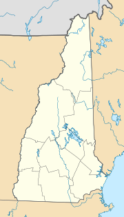
Bartlett, New Hampshire
| Bartlett | ||
|---|---|---|
|
Location in New Hampshire
|
||
| Basic data | ||
| Foundation : | 1790 | |
| State : | United States | |
| State : | New Hampshire | |
| County : | Carroll County | |
| Coordinates : | 44 ° 5 ′ N , 71 ° 13 ′ W | |
| Time zone : | Eastern ( UTC − 5 / −4 ) | |
| Residents : | 2,788 (as of 2010) | |
| Population density : | 14.4 inhabitants per km 2 | |
| Area : | 195.0 km 2 (approx. 75 mi 2 ) of which 193.9 km 2 (approx. 75 mi 2 ) are land |
|
| Height : | 226 m | |
| Postal code : | 03812 | |
| Area code : | +1 603 | |
| FIPS : | 33-03700 | |
| GNIS ID : | 0873539 | |
| Website : | www.BartlettNH.org | |
Bartlett is a place in Carroll County in New Hampshire in the United States . The population was 2788 according to the 2010 census . Bartlett includes the villages of Glen , Lower Bartlett, and Intervale . It is located in the White Mountains , surrounded by the White Mountain National Forest . In addition, there is the Attitash - winter sports area .
history
Settled after 1769 and incorporated in 1790, the place is named after Josiah Bartlett , the first chief executive officer to hold the title of governor, a representative to the Continental Congress and one of the first to sign the New Hampshire Declaration of Independence , taking his name directly that placed by John Hancock . Bartlett founded the New Hampshire Medical Society in 1791.
The place has two covered bridges . The spectacular view of the White Mountains made tourism the main source of income. In 1954, Story Land , a theme park for young children, opened in Glen. The Attitash Winter Sports Area opened in the 1960s and was the largest winter sports area in New Hampshire. The Conway Scenic Railroad , a heritage railroad near North Conway , maintains a daily train to the site for sightseeing.
geography
According to the United States Census Bureau , the place has a total area of 195 km², of which 0.01% is water. Bartlett is located in the catchment area of the Saco Rivers and the Ellis Rivers . The highest point in Bartlett is Mount Tremont at 1,028 m above sea level . Mount Parker, at 916 m, is to the north and Bear Mountain, at 975 m, is on the southern limit.
Trivia
The TV series The West Wing includes a character named Josiah Bartlet , a fictional descendant of the real-life Josiah Bartlett , after whom the place is named.
Individual evidence
- ↑ WRD of New Hampshire and Vermont . water.usgs.gov. Retrieved June 20, 2011.
