
Mohawk
.png)
The Mohawk or Kanien'kehá: ka or Kanien'kehake ("people from the land of flint") are the easternmost tribe of the Haudenosaunee ("people of the longhouse "), better known as the Iroquois League or Iroquois Confederation , an alliance of originally five (later six) tribes or nations of the Iroquois language family . In common parlance, these tribes are called the Iroquois . They are one of the indigenous groups of the Indians of North America .
The indigenous name in use today for the Iroquois League is derived from two phonetically similar but etymologically different words in the Seneca language: Hodínöhšö: ni: h ("people of the long house") or Hodínöhsö: ni: h ("long house builder "), the Mohawk, however, referred to the confederation in their language as Rotinonsionni ("people of the longhouse").
The indigenous names or designations for the individual tribes / nations are first given in the naming convention commonly used today, followed by the self-designation ( autonym ) if possible , then the Seneca designation (historically mostly the most common), then the Mohawk designation and finally the ceremonial council name (mostly borrowed from the Mohawk).
The nations of the Iroquois League included (from east to west):
- Mohawk ( Kanien'kehá: ka / Kanien'kehake - "People from the Land of Flint ", Kanienkahagen; Council name: "Guardian / Guardian of the Eastern Gate")
- Oneida ( Onyota'a: ka / Onyota'ake - "people of the (upright) standing stone", Onayotekaono or Oneniotehá: ka / Oneniote'á: ka; Council name: Latilutakówa (Onondaga) or Nihatironta'kó: wa (Mohawk) - "People of the big trees / tree trunks")
- Onondaga ( Onoñda'gega '/ Onöñda'gaga' , Onundagaono or Ononta'kehá: ka - "people from the place on the hills, ie from Onondaga", council name: Gana'dagwëni: io'geh or Rotishennakéhte (Mohawk) or Kayečisnakwe 'nì · yu' (Tuscarora) - "keeper of the council fire")
- Cayuga ( Gayogohó: no ' - "People of the Great Marshes", Guyohkohnyoh or Kanawakonhá: ka, Alternative Mohawk name: Kahoniokwenhá: ke - "People from the place where the boats are taken out of the water", Council name: Shotinennawen'tó : wane - "people / keepers of the great pipe")
- Seneca ( Onondowahgah / Onödowá'ga: ' - "People from the great mountain", Tsonontowanehá: ka / Tsonontowane'á: ka - "People from Tsonontó: wane (the great mountain)", Alternative Mohawk name: Shotinontó: wane - " Your (inhabited) mountain is big ", council name: Rontehnhohanónhnha / Ratihnhohanónhnha or Ronatehnhóhonte / Rotihnhóhonte -" guardian / guardian of the western gate ") and from 1722
- Tuscarora ( Ska-Ruh-Reh - "hemp collectors" or "shirt-wearing people", Thatihskarò: roks / Tehatiskaró: ros / Taskaroraha: ka / Taskarorahaka; had no right to vote in the council, were represented by the Oneida).
The territory of the Iroquois League was in what is now the central part of the US state of New York . The Mohawk's residential and hunting area was the largest within the Iroquois League and was furthest to the east; they were therefore called guardians of the eastern gate - the Seneca with about 4,000 tribesmen by far the largest tribe within the league were the westernmost nation and therefore the guardians of the western gate (since the Iroquois / Haudenosaunee compared their alliance with a longhouse).
The Iroquois League was first known to the French as Ligue des Iroquois and later as Confédération iroquoise ("Iroquois League ") or Ligue des Cinq-Nations and to the British as Five Nations ("Five Nations"); from 1722 with the entry of Tuscarora after the lost Tuscarora War as Ligue des Six Nations or Six Nations ("Six Nations"). Politically, had the Seneca in the final decision-making in the Council (Grand Council) of the Haudenosaunee as so-called. "Older Brothers" ( Elder Brothers very large) together with the Mohawk and Onondaga impact. Due to the central / central location of their tribal area, their capital "Onondaga" was also the seat of the Great Council (consisting of 50 elected clan chiefs or Hoyane ) of the Haudenosaunee and the Onondaga symbolically the keepers of the council fire of the Iroquois League ; They were responsible for the preparation, organization and decision-making of the council meetings as well as the preservation of the wampums , which were used to document the council decisions. The chiefs were organized into three groups: the "older brothers" ( Older Brothers - 8 Seneca chiefs and 9 Mohawk chiefs), the "younger brothers" ( Younger Brothers , with 9 Oneida chiefs and 10 Cayuga chiefs) and the "keepers of the council fire" ( fire keepers , with 14 Onondaga chiefs), the Onondaga therefore had an outstanding and often decisive function. Today there are also 6 Tuscaro chiefs, previously the Tuscarora had no voting rights in the tribal council.
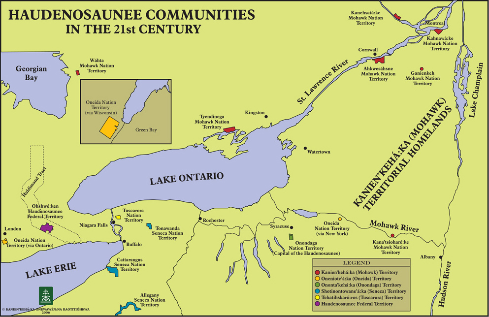
Today, the majority of the 45,000 Mohawk live in communities on the St. Lawrence River and in southern Ontario in Canada , as well as in two communities in the US state of New York.
territory
The Mohawk residential area in what is now upstate New York (with the counties: Schenectady, Montgomery, Herkimer, Oneida, Otsego, Montgomery, Herkimer and Schoharie) was called Kanienkeh ("Land of Flint ") and consequently they called themselves Kanien'kehá : ka (also: Kenienke'haka / Kanyen'kehaka - "People from the Land of Flint"), it stretched from the Mohawk River Valley (Mohawk: Teionontatátie / Teiehonwahkwà: tha , also: Tsi ionnontatá: ses ) in the south (in its Their main villages were located in the river valley) to the Saint Lawrence River ( Ken'tarókwen , Kaniatarowanenneh - "great waterway") in the north (the border with the Saint Lawrence Iroquois and later Wendat peoples), from the Richelieu River ( Kaniá: tare tsi kahnhokà: ronte ), Lake Champlain ( Ioniatarakwà: ronte ) and Lake George ( Kaniá: taro'kte ) in the east (border area to the Missisquoi and Sokoki of the Western Abenaki (Mohawk: Ratinèn: taks / Anèn: taks - “They eat pines “) And members of the hostile powerful Wabanaki Confederation as well the Mahican) to the territory of the Oneida along the Oneida River ( Ononhwaróhare ) and Oneida Lake ( Ononhwaróhare , the "thumb" of the Finger Lakes ) in the west. The hunting grounds also extended along the Schoharie Creek ( Ioskóhare ) west of today's city of Amsterdam upstream to East Canada Creek east of Little Falls and in the north to the Adirondack Mountains (derived from the Mohawk word : Adiro: daks / Ratirón: taks - "Those who eat trees / bark", a derogatory term for neighboring New England - Algonquin ) (hard-fought border areas against the hostile Mahican Confederation ), in the south to the eastern arm of the Susquehanna River ( Kawehnohkowanénhne ) near Oneonta ( Onenièn: ton ) in Otsego County (Mohawk: "place / place of rocks") (the border with the hostile Susquehannock ).
The main trade route between the Atlantic coast ( Hudson River ( Ka'nón: no ) and Mohawk River Valleys; mostly residential areas of the Eastern Algonquin and the western Iroquois-speaking peoples) led through the territory of the Mohawk to the Great Lakes (via Wood Creek, Oneida Lake, Oswego River; residential areas of the "Western Iroquois, ie Seneca and Cayuga", other Iroquois-speaking peoples (Huron, Petun, neutrals, Erie, etc.) and the Central Algonquin).
The route ran from Albany , today's capital of the US state New York (Mohawk: Skahnéhtati , Sche-negh-ta-da - “Beyond the pines”, “on the other side of the pine country”, “through the pine forests”) westwards to Schenectady (corruption of the Mohawk name for Albany, actually: Onon'onhrakónhne ), then the Mohawk River upstream to Fort Stanwix , today's Rome ( Teiehonwahkwà: tha ). Here, Oneida Carry or The Great Carrying Place (or: Trow Plat in Dutch , Iroquois: De-o-Wain-Sta ) was an important portage on the goods and the fur trading boats called bateau about one to six miles overland to Wood Creek (Iroquois: Kah-ne-go-dick ) had to be transported, which flows into Oneida Lake.
After crossing the Oneida Lake (secured by Fort Brewerton ) the route led the Oneida River downstream; together with the Seneca River (the lower course is sometimes called the Onondaga River) it now forms the Oswego River , a tributary of Lake Ontario ( Oniatarí: io - "beautiful lake" or "large lake"), which near Oswego (Mohawk: "mouth") , literally: "small water (Oswego River) that flows into the large one (Lake Ontario)") flows into the lake. A little further downstream was Fort Oswego , a fortified trading post that was built by the English in the 18th century to divert Indian trade from the French trading posts on the Saint Lawrence River. Upstream was the Onondaga Lake ( Kanontà: 'a ) and near it the main village of the Onondaga.
There were reportedly three to eight Mohawk villages in the 17th century. This difference may be due to population losses due to wars, epidemics and emigration . Were certainly confirmed three fortified by palisades main villages of the Mohawk River, which therefore often called "Mohawk Castles" or on the south bank castles were called, and several smaller settlements. The name of the easternmost village, also called First Castle , changed several times in the 1630s and 1640s. The Mohawk used to change the name of a village when it was rebuilt elsewhere. In 1634 this village was called Onekagoncka , around 1644 it was called Asserue or Ossernenon , in 1646 it was named Oneugioure and in 1659 Kaghnuwage . In 1666 it was burned down by the French and later rebuilt north of the river as Caughnawaga (Kahnawà: ke) ("place on the rapids / falls of the Mohawk River"). Because of its size and importance, it was also known as Indian Castle and the Mohawk also called it Gandaouage (Kachnawage) ("fortified place"). The village, newly built in 1676 on the south bank of the Saint Lawrence River - across from Montreal - and near the Lachine rapids in Québec , Canada ( Kana: ta - "settlement" or "city") was therefore also named Caughnawaga (Kahnawà : ke) called.
The second main village of the Mohawk they called Canajoharie (Kana'tsóhare) ("the pot that washes itself") or Kanagaro . It was about five miles from First Castle and was rebuilt north of the river after being destroyed by the French in 1666. The third and largest of the main villages was called Tiononderoga (Teioniataró: ken) (also: Tio (n) nontogue (n), Tionondog (u) en - "confluence of two rivers" ) and was about a kilometer from the inhabitants after the annihilation in 1666 remotely rebuilt. The fortified Mohawk villages were also distinguished due to its location along the Mohawk River: the Lower Mohawk Castle was Tiononderoga called at Fort Hunter, as this was (to the east) downstream, the thirty kilometers upstream (west) located Canajoharie therefore as Upper Mohawk Castle .
Surname
The term mohawk has been used by English settlers in southern New England since the 17th century . The term appears in different spellings, such as Mahwuke, Mohack, Mowack, Mohogg, Maqua and Mohowawog . Mohowawog is etymologically correct term from the year 1638, consisting of a language of the Narragansett comes and cannibals or cannibal means. The Mohawk's own name was Kanien'kehá: ka and basically means people from the land of flint .
Culture in the 17th century

The Mohawk were typical woodland Indians before they came into contact with Europeans. They were semi-sedentary farmers and protected their villages in times of war with palisades . They had no access to the coast and were therefore more dependent on agriculture than the Algonquin tribes in the east. The habitat of the Mohawk was typically divided into two areas, on the one hand in cleared clearings with longhouses and gardens, on the other hand in the surrounding forests with game and possible enemies. The clearings were the responsibility of the women. The residents of each longhouse were subordinate to the so-called clan mother , usually the oldest woman living there. The woods were the domain of the men who made offerings to the spirits and asked for rich booty. The Mohawk cleared the forests by burning the trees close to the roots and causing the leaves to fall off. This allowed the sun to reach the forest floor and the ash enriched the soil. In the following year the trees were felled and corn, beans and pumpkins were grown in the loosened soil. When fertility declined after a few years, new areas were cleared. About every 15 to 20 years the fertility of the soil was depleted and the wood available for the fireplace and the construction of new longhouses and palisades became scarce. That was the signal to give up the site and build a new village nearby.
An essential livelihood of the Mohawk was agriculture, which, however, made it dependent on good harvests, high-yield crops and reliable storage. Each larger village consisted of about 20 to 30 longhouses with a long corridor running through them. To the right and left were divided living areas for up to twenty families, two of which shared a fireplace. Like all Iroquois tribes, the Mohawk were aligned with their maternal lines , men had to move into their wife's house when they married ( matrilocal ) and a child always belonged to the mother's clan .
The family was the smallest economically autonomous unit; several families lived in one longhouse and several longhouses formed a clan with animal names. Each clan was assigned to a phratry (clan association) and the Mohawk, like the other Iroquois tribes, consisted of two phratias. This is the name of a kinship group who traced their togetherness to a common mythical ancestor . The male and female clan heads formed the tribal council. The Iroquois was the parent of the tribal council Bundesrat (English, Iroquois Grand Council ) comprised of 50 sachems consisted of which the Mohawk presented nine representatives. The Federal Council always met in Onondaga .
history
First contact with Europeans
As the easternmost Iroquois tribe, the Mohawk were the first to come into contact with Europeans. At the end of the 16th century, the Mohawk waged war against the Algonquin and Montagnais . Both tribes traded with the French in Tadoussac and exchanged skins for European goods, including iron axes, knives and swords. One of the Mohawk's goals was to capture these European weapons. After Québec was founded in 1609, the French supported their Algonquin trading partners and killed around a hundred Mohawk warriors near the mouth of the Richelieu River . For the Mohawk, their raids on the St. Lawrence River became more and more costly. In 1611 Samuel de Champlain accompanied a campaign by the Algonquin against the Mohawk on the south-west bank of Lake Champlain , as a result of which they killed numerous warriors and some chiefs. After that, the Mohawk stopped their attacks on the Algonquin.
At the same time, Dutch fur traders appeared on the Hudson River , which was explored by Henry Hudson in 1609 . The Dutch won the Mohawk as a trading partner, but they had to cross the Mahican territory to reach the Hudson River. Apparently they had previously signed a peace treaty with the Mahican, as nothing is known of any incidents. In 1615 the Dutch supported an attack by the Mohawk on the Susquehannock . The Dutch tried through the Mahican to establish trade relations between their trading center Fort Orange and the Algonquin and Montagnais. The Mohawk wanted to forestall this alliance and attacked the Mahican. As a result of a bitter war from 1624 to 1628, the Mohawk were able to expand their sphere of influence and gain control of Fort Orange and its surroundings. The Mohawk achieved that their enemies were no longer allowed to trade with the Dutch and that they would act as mediators between the Dutch traders and the other Iroquois tribes in the west. The Dutch didn't like this rule, but they were too weak to resist. During the 17th century, the Mohawk became more and more dependent on European goods. They therefore needed additional quantities of beaver pelts for trading and started raids again on the Algonquin. In doing so, they captured both European goods and beaver pelts. Several times they asked the French for neutrality in disputes between the Indians, as well as for good trade relations with all tribes. If these demands are not met, they threatened war and expulsion of the French from Montreal and Trois-Rivières .
Beaver Wars
In the early 1640s, Mohawk rifles were received in large numbers, first from the English and later from the Dutch. The European weapons changed the way they waged war. The traditional Iroquois skirmish began with abuse, insults and a few mutual volleys of arrows, then led to a man-to-man fight with spears and clubs and ended with a retreat into a prepared hiding place, taking the dead and wounded with them. Now the Mohawk preferred to fight in the dense forests, took cover behind trees and shot when they found a target. Father Jérôme Lalemant was amazed at the military capabilities of the Mohawk, who were able to use their new firepower accurately.
The Mohawk intensified their attacks on the French and their trading partners, as well as the Algonquin and Hurons allied with them . This began the so-called Beaver Wars (1640–1701), an uninterrupted series of conflicts between the Iroquois and their neighboring tribes, allied with France. This was primarily about dominance in trade with the Europeans. After 1646, the Mohawk supported the western Iroquois tribes to subdue the Hurons, Petun , Neutral and Erie . They captured large quantities of beaver fur and made numerous prisoners. These were adopted and incorporated into the tribe to compensate for the loss of people from the epidemics brought in by Europeans and the ongoing wars. The southern neighbors of the Mohawk, the Susquehannock , were able to successfully defend themselves against the attacks of the Mohawk in 1651/52.
Maintaining public order within the tribe became increasingly difficult. Problems turned out to be the increasing dependence on European goods, the unprecedented high mortality rate from new, unknown diseases and the need to integrate a large number of foreign Indians into the tribe. There was also increasing abuse of alcohol, which was brought into the villages by Dutch traders. The Mohawk's attempts to control the Western Iroquois trade relations with European traders split the Iroquois League. To prevent isolation, the Mohawk followed the other tribes of the alliance and in 1653 signed a peace treaty with the French. Between 1655 and 1659, the Mohawk received four visits from the French Jesuit Simon le Moyne . Nevertheless, many Mohawk distrusted this peace and after several bloody incidents they urged the Onondaga to dissolve the recently established Jesuit mission Sainte Marie de Gannentaha in their midst.
In 1664 New York became a British colony. This change hardly affected the Mohawk and they traded with the Dutch in Albany , who continued to operate there under the English flag. English goods were generally considered to be better and cheaper than French goods, which strengthened the Mohawk's position in the fur trade with Albany. The other tribes of the league again made peace with the French in 1665. For them, the Mohawk represented a great danger and in the winter of 1665/66 an expedition led by Daniel de Rémy de Courcelle set out to attack the Mohawk villages. They were ambushed and the mission failed. A second, successful expedition under Alexandre de Prouville de Tracy followed in autumn 1666 and destroyed the Mohawk villages and their maize stocks. In 1667, the Mohawk and all other tribes of the Iroquois League signed a peace treaty with the French in Québec . In the same year the Jesuit fathers Jacques Frémin and Jean Pierron visited the land of the Mohawk to set up new missions there.
Mohawk in Canada
In the following decade, numerous Iroquois, including many Mohawk, left their traditional territory and settled on the Saint Lawrence River near Montreal. Around 1670 two settlements were built, Caughnawaga on the south bank of the river and a second, Mount Royal , on the north side on the Île de Montréal . They lived there as in their home villages, although they had converted to Catholicism. They were now considered French allies and fought several times on the French side against the English and various Indian tribes, including against Iroquois, who had stayed in their old homeland. In the middle of the 18th century, two more settlements emerged on the St. Lawrence River. The first consisted mainly of members of the Onondaga and was built at Oswegatchie (now Odgensburg ) in the late 1740s . The second was created at the same time near Saint-Régis by the Iroquois from Caughnawaga. Both settlements should offer protection against a possible English invasion .
The Mohawk migration from the Mohawk Valley to St. Lawrence continued in the 1680s. At the same time, relations between the French and the Iroquois League deteriorated again. Initially, the residents of Caughnawagas sought neutrality, but were pushed to the French side in the course of the conflict. In King William's War (1688-1697) Caughnawaga was a target of Iroquois raids. The residents took part in French expeditions against the Iroquois. After the Lachine massacre in 1689, the Caughnawagas fled to Montreal for a year. In 1693 the French sent an expedition, reinforced by Indian warriors from Caughnawaga and Mount Royal, into the Mohawk Valley and burned the Mohawk villages. After Louis de Buades' campaign against the Onondaga in 1696, the Iroquois League concluded a peace treaty with the French in 1701. At that time, around two thirds of all Mohawk lived in Canada.
Allies of the English


In Queen Anne's War (1703–1713) Iroquois were involved in numerous raids in New England, for example in the attack on Deerfield in 1704 and on Groton in 1707. The English tried several times to win the Iroquois on their side. These efforts culminated in 1710 with the visit of four Indian "kings" to London. Three of these kings were chiefs of the Mohawk, the fourth a chief of the Mahican. Another Mohawk chief had died on the crossing. The Indians had an audience with Queen Anne and asked for English missionaries. Queen Anne built Fort Hunter at the confluence of Schoharie Creek and Mohawk Rivers. A chapel was also built there, which marked the beginning of intensive Protestant missionary work among the Iroquois.
At that time there were two main Mohawk villages in the Mohawk River valley, named by the Europeans because of their location along the river: Tiononderoga (Teioniataró: ken) ("confluence of two rivers") at Fort Hunter downstream (further east ) was therefore known as Lower Mohawk Castle and Canajoharie (Kana'tsóhare), which is around thirty kilometers upstream (further west), as Upper Mohawk Castle . Around 1713 Tiononderoga consisted of about thirty to forty long houses and had 360 residents, Canajoharie had twenty to thirty houses and around 200 residents. Both settlements were protected by palisades. In addition, there were several small settlements in the Mohawk Valley with a maximum of seven or eight longhouses.
After Fort Hunter was built, the area was considered relatively safe. White immigrants bought land from the Indians and began to settle in the area. In 1713 the place Palatine was created on the north bank of the Mohawk River. It was founded by the Palatines or Palatine, the first German mass emigration to North America around 1709. They settled on Schoharie Creek and their numbers grew so rapidly in the region that the Mohawk River between Fort Hunter and Frankfort was called the "German River". At the same time there were European dealers who wanted to move the fur trade center from Albany to Schenectady . Around 1730, cargo boats transported goods from the fur traders and the settlers' harvest yields to the trading centers by water. In 1727 the mission station at Fort Hunter was reopened under John Miln . He was succeeded by Henry Barclay , who had the chapel renovated in 1741. The following year there were the first schools in the main Mohawk villages and in 1743 the tribesmen are said to have converted at least nominally to the Christian faith .
Although the Mohawk sold their land on the Mohawk and Schoharie Rivers, they continued to participate in the lucrative fur trade. One of the most famous fur traders in the region was William Johnson , who opened trading posts in Oqua on the Susquehanna and Mohawk River in 1738 . As his business flourished, his reputation grew particularly with the Mohawk. He was able to influence them in the British interest, took over a command in the British Army and played a role in King George's War (1744-1748) and explicitly in the Seven Years' War in North America (1754-1762). He was made a baronet in 1755 for his service in the Battle of Lake George . After the war he continued to use his influence with the Indians of the Northeast and was instrumental in political decisions until his death in 1774. In 1768 he took part in the negotiations for the Treaty of Fort Stanwix , in which a new border between Indian land and the area populated by whites was established. The result was the Royal Proclamation of 1763 .
Around 1770, shortly before the American War of Independence (1776–1783), the Mohawk who remained in the Mohawk Valley were doing better economically than most of the white farmers living there. They still lived there in two places, namely at Fort Hunter and in Canajoharie. At that time, the Lower Mohawk at Fort Hunter had 185 and the Upper Mohawk at Canajoharie 221 tribesmen. After the war, not a single Mohawk lived in the Mohawk Valley; they had all moved to Canada.
American War of Independence

The Mohawk had stronger and older ties with England than the other tribes of the Iroquois League. When the war of independence between the colonists and the English crown began, numerous Mohawks fought on the British side. Not everyone took part, however, and some chiefs insisted on neutrality. The most famous of them was Little Abraham or Tigoransera , who publicly affirmed the neutrality of the Mohawk on several occasions. In 1777, the two Mohawk settlements were attacked, looted and destroyed by the Americans and Oneida. About a hundred Lower Mohawk fled to the British and joined General John Burgoyne's army, fought with them in New York and finally moved to Canada. Few remained at Fort Hunter and were captured by General John Sullivan in October 1779 for spying for the enemy . The Lower Mohawk, who fled to Canada in 1777, established a settlement at Lachine under the leadership of Captain John Deserontyon . Around the same time, the Upper Mohawk rallied under Captain Joseph Brant at Fort Niagara . As the war progressed, both groups fought on the Northwest Front of New York. Especially Captain Brant's actions gained some notoriety.
After the end of the war, it was impossible for these Mohawks to return to their old homeland due to the events. The Mohawk, allied with the Americans, were understandably unwilling to settle in this area. Governor Frederick Haldimand managed to have the Mohawk led by Joseph Brant relocated to Ontario. They received land from the Mississauga on Quinté Bay in the fall of 1783 . In addition, in 1784, Haldimand acquired a large piece of land on the Grand River to reunite the Mohawk. Deserontyon was of the opinion that this area was too close to the American border and therefore moved with his followers to the Bay of Quinté, while Brant and his people settled on the Grand River.
Mohawk reservations
When the Mohawk, who had fought on the British side in the War of Independence, left their homeland and moved to Canada, they met numerous compatriots there. Their ancestors had stood on the French side in the almost one hundred years of conflict between France and England and sought refuge in Canada. After the War of Independence in 1783, there were a total of six reservations in Canada , namely Grand River, Tyendinaga, Caughnawaga, St. Regis, Oka and Gibson . About a third of the residents had only moved to Canada after the war. In the Paris Peace Treaty , the border between Canada and the USA was redefined and essentially ran along the 45th parallel north. Accordingly, the border ran through the middle of the St. Regis reservation, the northern part was in Canada and the southern part in the United States. With the exception of the St. Regis reservation in the US state of New York, which was led by three elected chiefs from 1802, the management of all other reservations was in the hands of the traditional chiefs, who inherited the chiefhood. At the request of the Canadian government, the right to elect a chief was later introduced in the Canadian Mohawk reservations.
In the 19th century, the population in Caughnawaga, St. Regis, and Oka was predominantly Catholic. Around 1840 a Methodist church was opened for both parts in St. Regis . There was an Anglican Church in Tyendinaga as the majority of the population were Anglican , while in Oka the Methodists had numerous followers. In the seventeenth and eighteenth centuries the majority of the Mohawk had been converted to Christianity and their traditional beliefs were forgotten. The teachings of Handsome Lake therefore fell on poor soil for this tribe around 1799. They were supposed to be a bridge between the traditional Iroquois belief and Christianity . In the 1920s, the longhouse religion became known in Caughnawaga . It was a religion of the Indians living in longhouses, which arose from the teaching of Handsome Lakes. However, traditionalists rejected the belief because of Christian influences.
As in other Iroquois reserves, the dependence on hunting decreased and agriculture gained importance in the 19th century. In the 20th century, numerous mohawks lived off wage labor. Caughnawaga and St. Regis became known for their handicrafts such as basketry and beadwork.
When the Victoria Tubular Bridge was built over the St. Lawrence River near Caughnawaga in 1886 , engineers saw young Mohawk climbing effortlessly on the structures at dizzying heights. They asked these Indians to help build it. Since then, the Mohawk have been sought-after workers on high-rise construction sites across America. They helped build the Empire State Building in the 1930s and the World Trade Center in the 1970s . The legend that the Mohawk know no dizziness was investigated in 1958 by the anthropologist Morris Freilich in a field study in which he interviewed Indian workers. He came to the conclusion that it was a matter of practice and a question of courage, but Indian workers also know the fear of falling.
Mohawk population in 1890
| First nation / tribe | Mohawk name | reserve | Mohawk name | population | percent |
|---|---|---|---|---|---|
| Six Nations of the Grand River | Ne Ià: ia'k Nihononhontsá: ke (Six Nations Haudenosaunee Confederacy) | Six Nations 40 | O: se Kenhionhata: tie / Ose'kowáhne, today: Oshwé: ken Haudenosaunee Federal Territory (formerly: Grand River ) | 1,344 | 19.2% |
| Mohawks of the Bay of Quinte First Nation (MBQ) | Kenhtè: ke Kanyen'kehá: ka | Tyendinaga Mohawk Territory | Kenhtè: ke / Thaientané: ken (Tyendinaga) | 1,056 | 15.1% |
| Mohawks of Kahnawá: ke | Kahnawákeró: non | Kahnawake Mohawk Territory | Kahnawà: ke / Caughnawaga | 1,722 | 24.7% |
| Mohawk Nation at Akwesasne | Akwesasro: non | Akwesasne Mohawk Territory (Ontario: Akwesasne 59 + Quebec: Akwesasne Indian Reserve) | Akwesasne = formerly: Saint Regis, Quebec, Canada | 1,190 | 17.1% |
| St. Regis Mohawk Tribe (SRMT) | Akwesasro: non | St. Regis Mohawk Reservation | Akwesasne = Saint Regis, New York, USA | 1,157 | 16.5% |
| Mohawks of Kanesatake | Kanehsatà: kehró: non | Kanehsatà: ke Mohawk Territory | Kanehsatà: ke / Ka'neshatà: ke (formerly: Oka ) | 375 | 5.4% |
| Watha Mohawk Nation / Wahta Mohawks (formerly: Gibson Mohawk) | Wa'tkwanonhwera: ton | Wahta Mohawk Territory (formerly: Gibson Reserve) | Wahta (wahta) | 137 | 2.0% |
| Total | 6,981 | 100.0% |
According to the US Census Office. 11th census 1892
Mohawk today
In 1969/70 and 1990, during the Oka Crisis , armed clashes broke out between the Mohawks of Kanesatake (Kanehsatà: kehró: non) and the Canadian government, which culminated in a shootout between tribesmen and the Quebec provincial police and killed one policeman. The trigger was the plan to build a golf course in the Mohawk area. The protests escalated into a two-month road blockade near Oka , near Montreal, Québec. About 40 heavily armed members of the Mohawk Warrior Society were surrounded by 400 Canadian soldiers. The confrontation ended with the promise of negotiations, which, however, only resulted in unsatisfactory solutions. The "Mohawk philosopher", strictly speaking a member of the Seneca , John Mohawk Sotsisowah , stood out as the mediator in the dispute .
In some Mohawk communities there are two groups of chiefs who rule either together or against one another. The first group consists of chiefs with inherited dignity who are traditionally nominated by clan mothers, while the second group consists of the elected chiefs and councilors. Since the 1980s, the Mohawk have had controversial debates over gambling, land claims, traditional jurisdiction, taxes, and the Indian Act .
economy
In 1993 the Mohawk in St. Regis got permission from New York State to open the Akwesasne Mohawk Casino in Hogansburg for gambling. In 1996, the Kahnawake Gaming Commission was set up to issue licenses for online gambling , creating two hundred jobs on the reservation. The Indians rely on the constitutional rights of the indigenous people, while Canadian provincial and federal authorities consider the games of chance held in Kahnawake to be illegal.
Modern tribes and First Nations of the Mohawk
Today the Mohawk are organized in several First Nations in the Canadian provinces in the southeast of Canada and in two federally recognized tribes in the US state of New York in the northeast of the United States; there are several Mohawk communities - Kahnawake (Caughnawaga), Kanesatake (Oka), Akwesasne (St. Regis, New York and Quebec / Ontario, Canada), Tyendinaga (Bay of Quinte), Ganienkeh, Kanatsiohareke, Kahniakehaka of Ohsweken (Grand River ) and Wahta (Gibson) .
Tribes in New York, USA
In northeast New York are the places Ganienkeh / Kanièn꞉ke , Kanatsiohareke and St. Regis with Mohawk population.
- Ganienkeh or Kanièn꞉ke ("Land of Flint"): asettlement (2.4 km²) in the area of Moss Lake and Miner,originally illegally established in 1974 by traditional Mohawk from the reservations of Akwesasne and Kahnawake (and other Mohawk communities)Lake and parts of Adirondack Park , later the settlement was tolerated by the authorities. The Mohawk resident there consider themselves a sovereign nation and reject the sovereignty of both Canada and the United States; therefore they do not want any official state recognition by the authorities as a "tribe" (in the USA) or "first nation" (in Canada) and thus deliberately forego any state aid or tax relief they may be entitled to.
- Kanatsiohareke or Kana'tsioharè: ke ( Gah-nah-jo-ha-lay-gay - "place of the washed pot", "place of the clean pot" or "pot that washes itself"): the Kanatsiohareke Mohawk Community is a small Mohawk settlement rebuilt in 1993 on the north bank of the Mohawk River, with the aim of preserving and teaching the tradition, values, lifestyle, language and culture of the Mohawk. Kanatsiohareke, Inc. is a 501 (c) not-for-profit organization (under IRS Code 501c3 ) exempt from tax , but must generate its own income and regularly conduct cultural presentations, workshops, and academic events, including an annual strawberry festival. An on-site craft shop offers real handcrafted native crafts from across North America. In addition, as an organization recognized as a non-profit organization under Section 501 (c) (3) due to the Johnson Amendment, they are not allowed to become politically active, for example by donating to election campaign funds of certain politicians. The settlement and parish historically refers to one of the three main villages (called "Castles") of the Mohawk called Canajoharie (Kana'tsóhare) or "Upper Mohawk Castle", which was originally on the south bank of the Mohawk River.
- St. Regis Mohawk Tribe (SRMT) or Akwesasro: non (own name): for the Mohawk resident here is the "St. Regis Mohawk Reservation" (54.4 km²) along the Raquette River ( Ahná: wate ) and the Saint Regis River ( Ahkwesásne ) south of the St. Lawrence River in the north of the state of New York only the southern part of a single nation, which is only separated by the Canadian-American border from the northern part of the "Akwesasne Mohawk Nation" in Ontario and Quebec, Canada (With the Jay Treaty guaranteeing the Mohawk free border crossing). The main settlement of Saint Regis is located at the mouth of the river of the same name in the St. Lawrence River and is referred to by the Mohawks as "Kana: takon" ("the village, the settlement"). Both the "St. Regis Mohawk Reservation" and the two Canadian reservations in Ontario and Quebec are referred to by the Mohawks as "Akwesasne" or "Ahkwesáhsne" ("land where the partridge courted or drums"). The current official name of the river of the same name, the Mohawk tribe, the reservation and two Mohawk settlements (in New York State and Québec) were named after the Jesuit preacher Jean François Régis . Originally, in the area of today's St. Regis Mohawk Tribe (SRMT) and the Akwesasne Mohawk Nation, Christian Mohawk from Kahnawake (Caughnawaga) settled , which were later joined by Catholic Onondaga from Sawekatsi (Oswegatchie) (near Ogdensburg , New York State); these groups are symbolically represented by four clans: Turtle (tortoise) , wolf and bear (bear) for the Mohawk and Snipe (snipe birds) for the Onondaga. The reservation is cut over a length of approximately 205 km in an east-west direction by New York State Route 37; on the Canadian side, the "St. Regis Mohawk Reservation" is identical to the two Indian reserves in Ontario and Québec (population: approx. 3,300).
First Nations in Canada
The following Mohawk reservations exist in Canada: Akwesasne (St. Regis, 85.9 km²) on the border with New York, Kanesatake ( Oka , 11.9 km²) and Kahnawake (formerly Caughnawaga, 140.9 km²) in southern Quebec , and Tyendinaga (71.1 km²) and Wahta (Gibson, 60.2 km²) in southern Ontario. The largest reservation belongs to the Six Nations of the Grand River (183.2 km²) in southern Ontario, which brings together members of all six Iroquois tribes, with members of the Mohawk making up the majority.
- Mohawk Nation at Akwesasne or Akwesasro: non (own name): for the Mohawk resident here, the two Indian reserves (the approx. 11.86 km² Akwesasne Reserve No. 59 in the Stormont, Dundas and Glengarry United Counties of Ontario and the Akwesasne reserve in Québec) on the Canadian side of the border only the northern part of a single nation, the southern part is identical to the "St. Regis Mohawk Reservation" in the US state of New York. Today's Akwesasne Territory is located on the St. Lawrence River and along the estuaries of the Raquette River and the St. Regis River and includes several islands there; the two largest are Cornwall Island (Ontario) and the Île Saint-Régis (Québec). The two reserves are politically divided into three districts (each represented by three chiefs): "Kana: takon" ("the village, the settlement", St. Regis Village, Québec) and "Tsi Snaihne" (Snye or Chenail, Québec) as well as "Kawehno: ke" ( Cornwall Island - directly Cornwall or Tsi kaná: taien - "place / place where the city is" upstream, Ontario), the administrative seat is in Kana: takon. The two Canadian reserves are practically exclaves on US territory and can only be reached by passing through the "St. Regis Mohawk Reservation" to the south. Officially, the Canadian government regards the First Nation as two bands, the Mohawks of Akwesasne Volume 59 in Ontario and the Mohawks of Akwesasne Volume 15 in Québec (population: 14,000).
See also
literature
- Bruce G. Trigger (Ed.): Handbook of North American Indians . Vol. 15: Northeast. Smithsonian Institution Press, Washington DC 1978, ISBN 0-16-004575-4 .
- Dean R. Snow: The Iroquois . Blackwell Publishers, Boston 1994, ISBN 1-55786-938-3 .
- Rick Monture: "We Share Our Matters." Two Centuries of Writing and Resistance at Six Nations of the Grand River . University of Manitoba Press, 2016
Web links
- Akwesasne (German)
- Mohawk Creation Story
- Mohawk Institute, Geronimo Henry ( Memento from October 23, 2007 in the Internet Archive )
- Testicular sauna clothing and other cultural items
- The Wampum Chronicles: Mohawk Territory on the Internet , a website dedicated to Mohawk history, culture, and current events
- Iroquois Book of Rites
Individual evidence
- ↑ In the historical specialist literature and to this day the names for the Iroquois League, whose tribes and institutions are borrowed from the Seneca language (the largest tribe within the league at the time) - today these are supplemented or replaced by the Mohawk language, as this is currently the most widely spoken language of the Iroquois League (Onkwehonwehneha).
- ^ Haudenosaunee Confederacy - The League of Nations
- ↑ Kanienkeha - An open source endangered language initiative
- ↑ Kahnawà: ke Branch of the Mohawk Nation
- ↑ According to today's Haudenosaunee, however, the Mohawk council name most often given as "guardian / guardian of the eastern gate" is a frequent misunderstanding on the part of Europeans and can be traced back to their interpretation that the Mohawk as the easternmost nation as the "guardian of the eastern door within the Confederation "were known; however, this name was never officially used among the Haudenosaunee, but only used and spread by the Europeans.
- ^ Mohawk population
- ↑ Another name for the Algonquin peoples referred to the differences in the phonetics of the two language families: the Iroquois did not know any labial consonants ( b, p, m ), the articulation of which primarily involves the lips , and therefore the Algonquians also called them Rontsha'ká: nons / Atsha'ká: nons - "They gnaw on their lips" or as Rontewa'ká: nons / Atewa'ká: nons - "They gnaw on their words"
- ↑ a b c d Bruce G. Trigger (Ed.): Handbook of North American Indians . Vol. 15: Northeast, pp. 466-467. Smithsonian Institution Press, Washington DC 1978, ISBN 0-16-004575-4
- ↑ the hostile Eastern Algonquin-speaking Mahican Confederation called the area around Albany, however, Pempotowwuthut-Muhhcanneuw ("the place of the council fire of the Mahican nation"), since their capital Shodac (also Schodack) was located here
- ^ New York State Military Museum - Fort Stanwix
- ^ Fort Stanwix - The Oneida Carry and Its Early Fortifications: 1755-1757
- ↑ Bruce G. Trigger (Ed.): Handbook of North American Indians . Vol. 15: Northeast, p. 478
- ↑ Alvin M. Josephy jr .: America 1492. The Indian peoples before the discovery. S. 162. Fischer Verlag, Frankfurt am Main 1992, ISBN 3-10-036712-X
- ↑ a b Bruce G. Trigger (Ed.): Handbook of North American Indians . Vol. 15: Northeast, p. 466
- ↑ a b c d Bruce G. Trigger (Ed.): Handbook of North American Indians . Vol. 15: Northeast, pp. 467-468
- ↑ a b Bruce G. Trigger (Ed.): Handbook of North American Indians . Volume 15: Northeast, pp. 469-470.
- ↑ a b c d e Bruce G. Trigger (Ed.): Handbook of North American Indians . Vol. 15: Northeast, pp. 473-475
- ↑ a b c Bruce G. Trigger (Ed.): Handbook of North American Indians . Vol. 15: Northeast, pp. 475-478
- ↑ a b c d Bruce G. Trigger (Ed.): Handbook of North American Indians . Vol. 15: Northeast, pp. 477-478
- ↑ right ? Anxiety-free Indians C. Drösser DIE ZEIT 3/1999
- ↑ Morris Freilich, “Cultural persistence among the modern Iroquois,” Anthropos, Vol. 53 (1958), 473-483
- ↑ WARRIORS OF THE SKYLINE: A GENDERED STUDY OF MOHAWK WARRIOR CULTURE (PDF; 551 kB) by Anthony Patrick Curtis, 2005
- ^ John Gattuso (Ed.): APA-Guides USA Indianerreservate , pp. 303-304. RV Reise- und Verkehrsverlag GmbH, Munich 1992, ISBN 3-575-21425-5
- ↑ On the death of John Mohawk Sotsisowah, obituary of the Society for Threatened Peoples
- ↑ Wajdi Mouawad uses these controversies between whites and Indians, as well as their special legal status in Canada and the USA, in his novel "Anima" (2012, German 2014) as a continuous motif of the philosophically enriched crime story
- ↑ Today's congregations of the Haudenosaunee (Eng.)
- ^ Kahnawake - Gambling on internet casinos
- ↑ An Overview of Online Gaming in Canada ( Memento from October 31, 2006 in the Internet Archive )
- ↑ Ganienkeh
- ↑ Kanatsiohareke Mohawk community
- ↑ Mohawk, Oneida , Cayuga , Seneca , Onondaga , Tuscarora