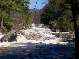
Raquette River
| Raquette River | ||
|
The Raquette River at Colton |
||
| Data | ||
| Water code | US : 977242 | |
| location | Franklin , Hamilton , St. Lawrence County in New York (USA) | |
| River system | Saint Lawrence River | |
| Drain over | Saint Lawrence River → Atlantic Ocean | |
| origin |
Blue Mountain Lake 43 ° 51 ′ 11 ″ N , 74 ° 28 ′ 5 ″ W. |
|
| Source height | 546 m | |
| muzzle |
St. Lawrence River Coordinates: 44 ° 59 ′ 35 ″ N , 74 ° 41 ′ 13 ″ W 44 ° 59 ′ 35 ″ N , 74 ° 41 ′ 13 ″ W |
|
| Mouth height | 46 m | |
| Height difference | 500 m | |
| Bottom slope | 1.8 ‰ | |
| length | 278 km | |
| Flowing lakes | Raquette Lake , Forked Lake , Long Lake , Tupper Lake | |
| Small towns | Colton , Potsdam , Norfolk , Massena | |
| Communities | Tupper Lake , Norwood , Raymondville | |
|
Course and catchment area of the Raquette River |
||
The Raquette River is a right tributary of the Saint Lawrence River in the north of the US state of New York .
The river has its origin in Blue Mountain Lake in the Adirondack Mountains . It flows mainly in a northerly direction. It flows through the Raquette Lake , Forked Lake , Long Lake and Tupper Lake in the upper reaches . Thereafter, there are a number of reservoirs along the river: Carry Falls Reservoir , Stark Falls Reservoir , Blake Falls Reservoir , Rainbow Falls Reservoir, and South Colton Reservoir . The river then passes the city of Potsdam as well as the places Norwood , Norfolk and Raymondville . In the lower reaches, the Raquette River turns to the northeast, passes Massena and flows into the Saint Lawrence River opposite Cornwall and the river island Cornwall Island .
The river can be explored by canoe or kayak.
Hydropower plants
The Raquette River is home to numerous hydroelectric power plants operated by Brookfield Power . Their total installed capacity is 181 MW.
Boralex operates the Sissonville run-of-river power plant with 3 MW north of Potsdam . The drop height is 4.88 m. The facility was built in 1989–1990. The expansion water volume is 60.4 m³ / s, the catchment area covers 434 km².
Hydroelectric power plants on the Raquette River downstream:
| Surname | Power in MW |
Number of turbines |
location | operator |
|---|---|---|---|---|
| Piercefield | 3 | 3 | ( ⊙ ) | Brookfield |
| Strong | 26th | 1 | ( ⊙ ) | Brookfield |
| Blake Falls | 15th | 1 | ( ⊙ ) | Brookfield |
| Rainbow Falls | 25th | 1 | ( ⊙ ) | Brookfield |
| Five Falls | 5 | 2 | ( ⊙ ) | Brookfield |
| South Colton | 21st | 1 | ( ⊙ ) | Brookfield |
| Higley | 6th | 4th | ( ⊙ ) | Brookfield |
| Colton | 30th | 3 | ( ⊙ ) | Brookfield |
| Hannawa | 7th | 2 | ( ⊙ ) | Brookfield |
| Sugar Island | 4th | 2 | ( ⊙ ) | Brookfield |
| East Dam Potsdam | ( ⊙ ) | Village of Potsdam | ||
| West Dam Potsdam | 2.5 | 2 | ( ⊙ ) | Village of Potsdam |
| Sissonville | 3 | 1 | ( ⊙ ) | Boralex |
| Hewittville | 3 | 1 | ( ⊙ ) | Brookfield |
| Unvionville | 3 | 1 | ( ⊙ ) | Brookfield |
| Norwood | 3 | 1 | ( ⊙ ) | Brookfield |
| Yaleville | 1 | 2 | ( ⊙ ) | Brookfield |
| East Norfolk | 4th | 1 | ( ⊙ ) | Brookfield |
| Norfolk | 5 | 1 | ( ⊙ ) | Brookfield |
| Raymondville | 2 | 1 | ( ⊙ ) | Brookfield |
Web links
Individual evidence
- ^ Blue Mountain Lake in the Geographic Names Information System of the United States Geological Survey
- ^ Raquette River in the Geographic Names Information System of the United States Geological Survey
- ^ A b Brookfield Renewable Energy Partners LP
- ^ Raquette River Recreation Corridor Brochure
- ↑ a b boralex.com (PDF)

