
Innu
The Innu / Ilnu (own designation: "human", "person") or Innut / Innuat / Ilnuatsh ("people"), formerly mostly Montagnais ( French for "mountain dwellers"), are a group of North American Indians who belong to the Count First Nations in Canada and live in the east of the Labrador Peninsula . About 8,000 years ago they moved to what they call Nitassinan ("Our Land") or Innu-assi ("Innu Land"). Today around 18,000 Innu live in eleven settlements within reservations in Québec and Labrador . To avoid confusion with the Inuit belonging to the Eskimo peoples , only the singular form “Innu / Ilnu” is used today and the correct plural form as “Innut / Innuat / Ilnuatsh” is dispensed with.
The Innu actually consist of two regional tribal groups, which differ in dialect and partly also in their way of life and culture: on the one hand the Ilnu , also called Western Montagnais , in the south and the Innu or Eastern Montagnais who live further north . Both groups are still referred to as “Montagnais” in the official language of Indigenous and Northern Affairs Canada , they call themselves Innu or Ilnu . On the other hand, the Naskapi ("people beyond the horizon") who live further north and who also refer to themselves as Innu or Iyiyiw belong to it.
In the past, the Innu were predominantly local semi-nomadic hunters and gatherers who hunted elk , caribou and small game in the open lichen forests of the boreal zone . Some coastal groups also farmed, fished and harvested maple syrup . The Naskapi, on the other hand, lived as nomads mostly in the light forest tundra from hunting elk and in the open tundra on caribou; also from fishing and collecting roots and wild plants.
The Innu were allied with the Atikamekw , Maliseet and Algonquin and later the Wyandot against their traditional enemies, the Mi'kmaq and Iroquois . Again and again during the Beaver Wars (1640–1701) the Iroquois invaded their territories and kidnapped women and warriors into slavery. They also invaded their hunting grounds in search of more furs. Since these disputes were conducted on the part of the Iroquois with hitherto unknown brutality, the Innu now also took over the cruelty of their enemies. The Naskapi, on the other hand, were often in conflict with the Inuit advancing southwards in the east.

language
Their language, the Ilnu-Aimun or Innu-Aimun , belongs to the regional language group of the “Central Algonquin” of the Algonquin language family and belongs to the dialect continuum of the Cree languages (Cree – Montagnais – Naskapi) . It forms the easternmost Cree dialects. Since today's Innu and Naskapi consider themselves to be an ethnic group with a common language (divided into several dialects) and the Naskapi also refer to their dialects as Innu-Aimun , today in linguistics and specialist literature to better differentiate between the " Montagnais Innu " Innu and the " Naskapi Innu " of the Naskapi are differentiated - as an umbrella term for all dialects of the Innu-Aimun , however, the term " Montagnais-Naskapi " is common.
Usually the individual Cree dialects are based on sound changes by means of comparative phonetics after the realization of the assumed Proto-Algonquin phoneme * r / * l (depending on the dialect in: y / j /; ð / th / ð , θ /; r / ɹ /; l / l /; n / n /) as well as the palatalization of * k (if it precedes a front tongue vowel ) to either c / ts / or č / tʃ /; all palatalized dialects are regarded as " Montagnais-Naskapi ", all non-palatalized dialects as "Cree". However, this is partially misleading, since according to these criteria the dialects of the "East Cree" (also: "James Bay Cree" or "East Main Cree", palatalized y dialects) the "Montagnais-Naskapi" or "Innu-Aimun" “Would be attributable. To make a simple distinction between “Cree” and “Montagnais-Naskapi” , reference is made to the written reproduction of the individual dialects: in contrast to other Cree languages that use the Cree syllabary , the “Montagnais-Naskapi” uses the Latin alphabet . Although the "Naskapi Innu" once also used the Cree syllabary and the Atikamekw (Nehiromowin / Nehirâmowin) the Latin alphabet, the former is not counted among the "Cree" dialects in the narrower sense, whereas the "Atikamekw" counts as "Cree" becomes.
At least four regional (or six) mutually understandable dialects can be distinguished (from southwest to northeast: l, n, y - dialects):
I. Western or southern Montagnais ( l -dialect; also: Ilnu-Aimun or Nenueun / Neːhlweːuːn)
- Mashteuiatsh / Lac-Saint-Jean dialect (also: Nenueun / Neːhlweːuːn or Piekuakamiu-aimu) (almost † )
- Essipit / Les Escoumins dialect (also: Ilnu-Aimun, Leluwewn / Leːluweːw) ( † )
- Pessamit / Betsiamites dialect (also: Ilnu-Aimun, Leluwewn / Leːluweːw or Pessamiu-aimu)
II. Eastern Montagnais ( n -dialect, also: Innu-Aimun)
- Central Montagnais or Moisie Montagnais
- Uashat-Maliotenam / Sept-Iles-Malioténam dialect (also: Uashat mak Mani-utenam or Uashau-aimu)
- Matimekosh / Schefferville dialect
- Eastern Montagnais or Lower North Shore Montagnais (also: Mamiu-aimu or Mashkuanu-aimu)
- Ekuanitshit / Mingan dialect (also: Ekuanitshiu-aimu)
- Nutashkuanit / Natashquan dialect
- Unaman-shipit / La Romaine dialect
- Pakut-shipit / St-Augustine dialect (also: Pakut-shipiu-aimu)
- Labrador Montagnais or North West River Montagnais
- Tshishe-shastshit / Sheshatshiu dialect
III. Naskapi (also: Innu-Aimun or Iyuw Iyimuun)
- Western Naskapi or Naskapi (ᓇᔅᑲᐱ) (also: Iyuw Iyimuun ᐃᔪᐤ ᐃᔨᒧᐅᓐ, as a y -dialect it shares many linguistic properties with the Northern East Cree and also uses the Cree syllabary)
- Kawawachikamach / Fort Chimo (Schefferville) dialect (also: Puatshishaimu-aimu)
- Eastern Naskapi (also: Innu-Aimun, as an n -dialect it is closer to the neighboring Montagnais-Innu dialects than to the Western Naskapi, previously they also used the Cree syllabary)
- Natuashish / Davis Inlet dialect (also: Mushuau-aimun)
The Innu Aimun is spoken by over 8,000 people living in four reservations and ten villages in northeastern Québec and Labrador. The first dictionary was written as early as 1633. Today most of the Innu speak English or French as a second language.
The language name Innu Aimun describes both the language of the Innu (Montagnais) as a whole, especially that of the Eastern Montagnais (Innu) and the dialect of the Eastern Naskapi (Mushuau Innu in Natuashish) - but not the dialect of the Western Naskapi.
According to the 2011 census, around 11,000 Innu still spoke their mother tongue. According to the 2001 census, 5,870 of these native speakers were assigned to the Western Montagnais ( Ilnu Aimun ) and 2,620 to the Eastern ( Innu Aimun ). The Innu language is still lively except in two settlements and near the cities, especially in the settlements near Schefferville. Almost all Innu in Mashteuiatsh also speak Canadian French (called Mishtikushiu-Aimu ). Many Innu from Sheshatshiu, Labrador are fluent in Canadian English (called Akaneshau-Aimun ). After all, the Innu in Quebec speak Quebec French (called Kakusseshiu-Aimu ).
The use of the Innu-Aimun as the native language of the autochthonous population has increased again in recent years. A well-known author who writes in Innu-Aimun is Joséphine Bacon (* 1947) from Pessamit .
history
Early history
From the end of 1998 the Tshikapisk Foundation worked together with the Arctic Studies Center at the Smithsonian Institution for around a decade and a half on the archaeological development of the Kamestastin region. Artifacts up to 7,200 years old have been excavated and dated under the direction of Stephen Loring. Anthony Jenkinson (Tshikapisk Foundation) and Chelsee Arbor ( Memorial University of Newfoundland ) took part in the long-term excavations .
Most of the finds come from the area around the caribou hunt, on which the regional culture depended from the beginning. This also includes stone axes, so-called boulder pit cache sites , but also hunting tools such as stone blades from former spears (from the Point Revenge and Intermediate Periods, approx. 500 BC, but also those from around 3000 BC), scratches for the caribou skin from Kamestastin (approx. 3000 BC), one of the oldest sites. The earliest find, however, was made at the northern end of the Kamestastin Narrows ((GlCs-1), a blade that was dated to 5200 B.C. It dates from the time when the glaciers of the Last Cold Age were just melting in the region From 2002 (as of 2012) over 200 sites were identified there, which document the land use of the Innu in detail. At the same time, the massive use of quartz emerged as a “leitmotif.” The Pess site, which belongs to the Tshumushumapeu Complex, is similarly old (approx. 5000 BC), whose quartzite blades are possibly even older.
The earliest phase is known as the Early Maritime Archaic (approx. 6000-2500 BC). The first inhabitants hunted walruses and seals, as well as fish and game, especially caribou. Quartz and quartzite blades as well as triangular blades are characteristic of this early phase, along with small round scratches, stone axes and chisels. Burial places were found on the coast of Labrador and Québec, the Belle-Isle road at Blanc-Sablon and at L'Anse-Amour . There the skeleton of a 12-year-old boy was found lying on his stomach, with a large rock on his back, along with tools and a flute (approx. 5500 BC). This early phase can also be detected in the north of Labrador, in Nain .
It was followed by the late Maritime Archaic (approx. 2500–1500 BC). Much more numerous sites between Petit Mécatina and Blanc-Sablon belong to this period. The tools mentioned are still characteristic here, but there is also a type of stone that is only found in the north of Labrador, the so-called Ramah Chert, a translucent type of rock. Now mounds no longer prevailed, but cemeteries containing red ocher and broken tools - possibly to release their “ghosts”. Several families already lived in long houses. Since life was apparently different from that of neighboring areas, such as Labrador, it is called the Mecatina complex here.
Between 500 BC Chr. And the birth of Christ there was the strongest cooling in the post-ice age, so that Inuit , who led an appropriately adapted life, moved to the south of Labrador. Some of their descendants even traded with the Basques of Mécatina, who went whaling there , until the 18th century .
Its southernmost point was the area around Hopedale . In this culture, the tiny stone blades known as microblades are particularly noticeable. Rather, they lived in tent houses lit with the fat of mammals, not wood. Their culture was superseded by the Dorset culture for about 500 years . But their influence did not extend westward beyond St. Paul. Around 500 this culture died out in southern Labrador, but persisted in the north until around 1300 when it was ousted or absorbed by today's Inuit.
Overlapping is the so-called Intermediate Indian Period (approx. 1500 BC - Born), which stayed in the interior of Labrador and partly at the St. Lawrence estuary. A group of immigrants who had probably immigrated from the west slowly pushed the Inuit cultures northwards. Their culture was less concentrated on the seashore than on rivers and lakes. Scattered blades, leaf-shaped masses, scratches with enlarged ends and knock-off blades now predominate - still from the exotic Ramah Chert. For the first time, commercial objects appear, e.g. B. made of copper. However, a large part of the estuary near the estuary has been destroyed.
The Late Indian Period or Innu Culture began around 2000 years ago. The area of northern Quebec, Labrador and Newfoundland now seems to have been a relatively unified cultural area again. During this period, the Inuit are difficult to pin down because they have adapted their lifestyle, but they appear to have cooperated with the Basque whalers arriving in the 16th century.
The Vikings , whose settlement L'Anse aux Meadows on the Belle-Isle-Strasse can be proven, are otherwise culturally intangible and probably did not have any further influence on the Innu.
Basques (15th / 16th century to 18th century)
Between around 1530 and 1750, Basque ships regularly sailed into the fish and whale-rich fishing areas off the east coast. However, they may have come across these areas as early as the 15th century. The Innu traded with them, especially in Brest (Old Fort) and Grand Bay. From the perspective of the Basques working on the coast, the Innu came from the mountains. Hence their name Montagnais probably comes from this early meeting phase. They also supported the Basques with their fish processing, for which they received rusks, bread and cider. The Inuit, on the other hand, fought the Basques and attacked them with bows and arrows.
Two sites, the Île du Petit Mécatina and Harve Boulet, date from the early 17th to 18th centuries. Exclusively whalers already lived there, and at that time, especially on Mécatina, there was also trade with the Inuit. In addition to the Basques, fishermen also came from Brittany and England. In 1500 Gaspar Corte Real appeared off the coast, a Portuguese who first handed down the name Caneda.
French (16th century - 1763), Catholicization
When Jacques Cartier was still traveling to the St. Lawrence Valley in 1535, it was still inhabited by sedentary Iroquois who farmed, but who left for unknown reasons in the second half of the 16th century.
Around 1600, on the other hand, the Innu area reached into the headwaters of the rivers that flow into the St. Lorenz from the north, west to the Saint-Maurice , on the Côte Nord to Mingan and further east to the continually shifting border with the Inuit .
As early as 1599, Pierre Chauvin de Tonnetuit († 1603), a merchant from Honfleur in Normandy, received the fur trade monopoly . He tried to establish lasting trade relations with the Montagnais groups who came to Tadoussac from 1605 . He founded the first fur trading station in North America in 1600. His partner François Gravé du Pont (†> 1629), who from 1603 to 1607 had the settlement monopoly for North America between the 40th and 60th parallel, invited several Montagnais to the French court in 1602 and 1603, where they aroused great curiosity and von Gravé du Pont were treated kindly. They remained allies until the end of French rule.
1609–11 the French supported the Montagnais against the neighboring Iroquois. As long as the French did not try to force the Indians out of the fur trade in order to enforce their monopoly, the relationship was friendly, especially since the French had shown themselves to be important helpers against hostile tribes. By the 1620s at the latest, the Innu were already using metal tools and weapons around the trading post, some even wore European clothing.

The missionary work began with the arrival of the four Franciscan recollects called by Champlain in 1615. These four missionaries formed four different focuses, with Jean d'Olbeau being responsible for the Montagnards. Another missionary, Gabriel Sagard , was to become a historian of religious activities. The Jesuits joined the recollects as early as 1625, in view of the huge, unmanageable area. However, as long as no translations of the central Christian works, especially the Bible, existed, the conversion attempts kept getting stuck. Although the Jesuits had developed techniques for promoting drama, song, and dance, the successes remained modest. Therefore the missionaries began to adopt and use the sign systems and symbols of the Montagnais. Because the kind children responded particularly well to the brothers ’talk, they were used as a means to convert their parents. During a transition period they also used interpreters, but they could not help learning the language themselves.
Jean de Brébeuf spent the winter of 1625/26 with the Montagnais and learned their language. But Montagnais such as Pierre Pastedechouan also learned French in reverse - he even went to France for several years and helped Paul Lejeune in 1632/33 with the development of a dictionary. But he not only showed the typical consequences of a total loss of culture, but also increasingly forgot his mother tongue and behaved in the eyes of the missionaries extremely undisciplined. They later left him to his fate.
The rangers ( Coureurs des bois ) , such as Nicolas Marsolet , also acted as interpreters . He was ready to serve as an informant for Charles Lalement and his Jesuits and to teach them the Algonquian dialects he knew. But it was not until 1659 that language training had advanced so far and the accuracy of the translation was sufficient to send trained missionaries out. Linguistically unskilled missionaries were even sent back to France. Bonaventure Fabvres' Racines montagnaises was created as an aid , but it remained with manuscripts. Even if the Jesuits asked for a printing press as early as 1665 , the first did not come to Québec until 1764. The Dictionnaire montagnais-français from 1687 (by Antoine Silvy) was only published in 1974 in Montréal.
At least as serious as the cultural, even if initially superficial, interventions, was the missionaries' conviction that the Innu should be made settled. This was also due to the fact that the hiking trains, especially during the hunting season, were too strenuous for the French. In addition, France promoted settlement by granting land since 1627. From 1637 onwards, the first reductions were made, in which mostly baptized Indians lived, and there was often a kind of hospital in which sick Indians were cared for. In the reduction, they worked together with the friars and had to swear to forego their traditional rituals. The brothers also checked and punished. But financial problems, the superficiality of the increasingly obedient life cycle and the attacks of the Iroquois emptied the reductions, which were abandoned around 1670.
From 1635 the Jesuits tried to set up schools, 24 of which existed in the province in 1693. In 1636 the first seminaire was created for the Innu , in which boys between 10 and 14 were taught. In 1639 Marie de l'Incarnation, an Ursuline woman, learned the Innu language and founded a girls' school. But this attempt also ended in 1663 when the schools were practically no longer visited by indigenous people.
The French initially adopted place names from the language of the Indians, such as Québec or Cabano ('we create', term for a small town on Madawaska taken from the Montagnais), followed by numerous names for animals and plants, such as Caribou from the Mi. 'kmaq . Conversely, the French increasingly named places by remembering people or describing the place. In addition, a commercial mixed language was created that used elements of both languages.
On the other hand, there were violent clashes with the Inuit. In 1640 there was a battle on the Île des Esquimaux, on the St. Paul's River, in which a thousand Inuit are said to have been killed. A similar battle did not occur again until 1757 at Battle Harbor.
In 1661 Francois Bissot from Normandy, who had come to Canada before 1647, received the Isle aux Eufs and, above all, hunting and fishing rights on the north bank of the Saint-Lawrenz to Sept-Iles and to the "Grand Anse, to the land of the Eskimo where the Spaniards usually come to fish ”. This area became the seigneury of Mingan. In 1667 there were 3,215 non-Indians in 668 families in the colony.
Louis Joliet , who married a daughter of Bissot, became seigneur of Mingan. His trading empire extended as far as Lac Naskapis, today's Ashuanipi. For his discovery of the Mississippi, he received the Anticosti Island as a seigneurie in 1684 . He traveled north to the 56th parallel and was the first to draw maps of the area.
From around 1680 the number of Basques declined. Sieur Augustus de Courtemanche accordingly received permission to hunt from Kegaska to Hamilton Inlet and he made Baie de Phélypeau, now Bradore , his main port. In 1702 Augustin Le Gardeur de Courtmanche took over fishing rights between Kegaska and Hamilton Inlet. He had Fort Pontchartrain built in Brador and employed around 30 Innu families. Courtemanche had married the widow of Pierre Gratien Martel de Brouague, the granddaughter of Francois Bissot, five years earlier, so that a kind of family dynasty developed here. When Courtemanche died in 1717, his son-in-law Martel de Brouague took over his office until the English conquest in 1759/60. In 1743 he expanded his fur trade by building a trading post in Sheshatshiu.
The Seven Years' War (1756–63) began in America as early as 1754. In 1760, the trading establishments in Labrador fell to the English traders. This made the Labrador Company under Adam Lymburner a monopoly in the region north of the St. Lawrence River. With the return of St. Pierre to France, English loyalists came to this area.
British (1763–1871)
In 1767 the frigate HM Merlin received orders from Brador Harbor to go to Gros Mécatina , Fort St. Augustine and Baie-de Shecatica (Schicattakawica) because of seal-catching disputes.
When the US was recognized in 1783, its fishermen were allowed to catch off Newfoundland, but they were not allowed to go ashore. Nevertheless, fishermen from New Jersey established a position at Blanc-Sablon . In 1804, 1,400 American ships fished in the region off eastern Canada. After the war between the USA and Great Britain from 1812 to 1814, there was an economic crisis in the course of which Newfoundland was starving in 1817, followed three years later by the bankruptcy of the New Labrador Company , which had monopolized the trade. Robertson from La Tabatière , Kennedy from St. Augustine and Jones from Bradore use the space that is now free. The Americans did not regain full fishing rights until 1871.
The Hudson's Bay Company also had trading posts in the region, as had been on the North West River near Sheshatshiu since 1836 . In 1840 the Reverend Edward Cusack tried to set up a parish , but this was not achieved until 1863 with a chapel on St. Augustine's River . As early as 1858, C. C Carpenter established a mission and a school on Great Caribou Island . By 1865 at the latest, J. Wainwright did missionary work on the coast. The Dominion of Canada was founded in 1867, and in 1869 the Hudson's Bay Company renounced Rupert's Land .
Magical ritual
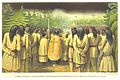
Christianized Innu in the Catholic procession on Seven Island (1862)
On road
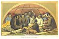
In a tent

Hunting scene

Seal hunt accident
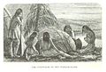
_LABRADOR-EXP._p428_THE_CONJUROR_IN_HIS_VAPOUR_BATH.jpg)
_LABRADOR-EXP._p378_ROMAN_CATHOLIC_PROCESSION_OF_MONTAGNAIS_AND_NASQUAPEES_AT_THE_MISSION_OF_SEVEN_ISLANDS.jpg)
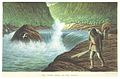
_LABRADOR-EXP._p012_THE_THIRD_RAPID_ON_THE_MOISIE.jpg)
_LABRADOR-EXP._p364_A_VISIT_TO_OTELNE_IN_HIS_LODGE.jpg)
_LABRADOR-EXP._p180_VIEW_FROM_THE_OJIAPISITAGAN_OR_TOF_OF_THE_RIDGE_PORTAGE_AT_THE_SUMMIT.jpg)
_LABRADOR-EXP._p627_SEAL_HUNTING_IN_THE_GULF.jpg)
Canada (since 1871)
For a long time, the Innu area remained outside the Indian policy customary in Canada. In the absence of development, the nomadic groups were practically intangible and were considered to be far removed from civilization. There was no money in circulation with them, the hunt provided what was necessary for life. However, the Spanish flu reached the region in 1918, with some Inuit villages losing up to three quarters of their inhabitants. How badly the Innu were affected is unclear.
Natural resources, infrastructure, end of hunting culture
The huge area inhabited by the Innu (Nutshimiu Innut 'Innu-Land') was long considered almost uninhabited and economically of little interest. In 1927 the eastern part of the province of Newfoundland was added, the rest went to Québec. Thus the Innu area was divided into two provinces.
Much more serious, however, was that the Crown Land was formally ceded by Great Britain to Canada in 1949 and the Innu lost their status as Indians - and with it all support. This was all the more serious as the fur industry collapsed with the global economic crisis and the caribou herds collapsed. This deprived the Innu of any economic basis.
In the 1950s, infrastructure began to be built with the construction of a railway line, which was completed in 1957. There was also an unpaved road to Happy Valley-Goose Bay until 1992 .
In 1957 a Catholic mission was established in Sheshatshiu. Government and mission put pressure on the z. Some of the Innu who lived in tents decided to settle down. The last resettlement took place in the winter of 1971/72, to Pukuatshipit. This ended the nomadic era and the children were made compulsory.
Some men were now working in the nickel and copper mines of Utshimassits and the copper mine northwest of Sept-Iles. Still, the caribou hunt lived on, as the largest herd of animals in North America, the George River Caribou herd of over 800,000 animals, still exists on the Ungava Peninsula . Another reason for the partial continuation of this way of life was the low number of job opportunities and the perceived dependence on the Canadian welfare state as humiliating. But the government undermined this lifestyle with strict hunting bans. A hospital and thus a limited supply structure was built in Sheshatshiu, but at the same time the deportation of the Innu allowed the construction of the Churchill Falls Hydroelectric Project - on the land of the Innu, without consultation, without participation.
In the mid-1990s, the disintegration of the Innu company was in full swing. Underemployment, addiction, powerlessness and degraded self-esteem, as well as foreignness in one's own country, were the basis for drug addiction, violence and a high suicide rate that attracted attention in the Canadian press for several years.
In 1994 the conflict threatened to escalate. A group of Innu women had evicted a Canadian judge and his police escort. Now the Innu Nation feared attacks by the federal police on the Davis Inlet reservation . Outside help was sought for mediation and turned to Peace Brigades International . This was a one-time event in that this organization otherwise only appeared in countries in the so-called Third World . She succeeded in provisional arbitration, but in August the government threatened to send the federal police to the reservation. Again the Peace Brigade succeeded in de-escalating, although the Innu were already preparing for a defense.
revival
In 1996, of the 1,000 or so inhabitants of the largest village, Sheshatshiu, only 135 were employed and the median income was $ 11,452. In 1997 the Queen of England visited the village and received a letter from the Innu summarizing the complaints.
The Innu resistance now concentrated on the bare essentials. The Canadian Forces Base Goose Bay , which had existed since the Second World War, had meanwhile been expanded to lend the allegedly empty hinterland to NATO partners for training purposes. The Bundeswehr also practiced low-level flights and bombings there. In 1994, Inuit, one of their leaders was Elizabeth Penashue, occupied such an area at Minipi.
A huge $ 2.9 billion mining project by Inco (Toronto) was planned in the mid-1990s, but the construction of the nickel mine in Voisey's Bay came about without any substantial involvement from Innu. Instead, they mainly suffered the ecological disadvantages, while the metals are transported to Argentia on Newfoundland and processed there. The up to 550 men in the mine are still flown in. The mine has its own runway, which is approached 4 to 6 times a week. However, if they are sufficiently qualified, the Innu should be given preference in the allocation of positions. In cooperation with the Inco Memorial University , a training and innovation center was also built (completed in 2004).
In this situation, the Tshikapisk Foundation was founded, a foundation that advocates cultural revival and its own economic base, especially for the young Innu. In 1999 the only institution of higher education, the Labrador College , began an attempt to process and convey the culture and history of the Innu. A few years later, Nutshimiu Atusseun emerged, an independent cultural institution within the framework of Human Resources Canada . But this support was limited in time, so that a foundation was created. From 2001 the Innu Cultural Center was built in Kamestastin, a village on a water-filled crater that was formed around 38 million years ago by the impact of a meteorite . In 2005, several guest accommodations were completed, on the roof of which there are now 48 solar panels. By using wind power, the foundation tries to become independent of expensive diesel generators. Both Air Labrador and the 51 percent Innu-owned airline Innu Mikun connect the lake with Goose Bay.
In February 2010, 150 Quebec innu sparked a heated public debate over Innu hunting rights when they went caribou hunting in an area in Newfoundland and Labrador Province. They were encamped in an area shared by the highly endangered Red Wine with the vast George River herd. Shawn Atleo , leader of the First Nations Congregation , defended hunting as the oldest Innu tradition.
Today's First Nations of the Ilnu / Innu (Montagnais)
Today's First Nations of the Ilnu / Innu are represented by a total of three tribal councils / Conseil Tribals vis-à-vis the provincial governments as well as vis-à-vis the federal government: the Conseil Tribal Mamuitun represents five communities (Mashteuiatsh, Essipit, Pessamit, Uashat-Maliotenam and Matimekush), the Conseil tribal Mamit Innuat in turn represents four communities of the Mamit Innuat ("Eastern Innu", literally: "Innu on the lower reaches of the St. Lawrence River or downstream") on the lower reaches of the St. Lawrence River and the Gulf of St. Lawrence (Ekuanitshu, Pakua Shipu, Unamen Shipu and Natashquan) and finally the Innu Nation which represents the only Innu community (Sheshatshiu) in Labrador.
Western Montagnais (Nehilaw and Ilnu)
Western / Southern Montagnais
-
Montagnais du Lac St-Jean (also: Première nation des Pekuakamiulnuatsh or Ilnuatsh du Pekuakami ; own name: Pekuakamiulnuatsh or Piekuakamiunnu - "Innu on the shallow lake, i.e. on Lac Saint-Jean ")
The center of their hunting and fishing grounds is Lac Saint- Jean or Piekuakamu / Pekuakami ("shallow lake"). Important rivers are the Péribonka and Ashuapmushuan, as well as the Mistassini and Mistassibi (the latter two rivers are less navigable, but allow easier access to remote areas). Due to limited navigability, the Métabetchouane , Ouiatchouan and other rivers are of less importance. Today's First Nation was settled in 1856 in the first ever established Innu reservation, then known as Ouiatchouan , which was officially established in Mashteuiatsh in 1985 (pronounced: Mass-teu-i-atsh, locative form : Matshiteuiat - “Where there is a point”, formerly “Pointe -Bleue "), about 6 km away from Roberval on the west bank of Lac Saint-Jean. Reserve: Mashteuiatsh , approx. 15 km², population January 2017: 6,626. -
Innue Essipit (also: Bande Innue Essipit , La Première Nation des Innus Essipit or Essipit Innu First Nation , own name: Essipiunnuat or Essipiunnu - "Innu along the mussel river, ie. On the Rivière des Escoumins ")
The reserve is 32 km northwest of Rivière Saguenay on the north bank of the Saint Lawrence River near Les Escoumins Bay, 40 km northeast of Tadoussac , reserve: Innue Essipit, approx. 88 ha, population January 2017: 747. -
Bande des Innus de Pessamit (also: Pessamit Innu Band , own name: Pessamiunnu - "Innu along the Rivière Betsiamites ")
The reserve is located on the north bank of the Saint Lawrence River , 54 km southwest of Baie-Comeau , Québec, at the mouth of the Rivière Betsiamites (Betsiamites River), whose name is derived from a place name for the so-called Betsiamites / Pessamu region through which it flows. Originally, the families of today's First Nations belonged to the Manikuakanishtikunnu ("Innu vom Manikuakanishtikᵘ, ie from the Rivière Manicouagan "), the Manicouagan Reserve established for them was abandoned in 1861 and the Innu had to resettle in the present reserve. There are also two other settlements, the residents of which have their own names: the Nanataunnu of Calvaire Street and the Pishtunnu of Pisto Street. Reserve: Betsiamites (Pessamu), approx. 252 km², population January 2017: 3,953.
Eastern Montagnais (Innu)
Headquarters / Moisie Montagnais
-
Innu Takuaikan Uashat Mak Mani-Utenam (also: Uashat-Maliotenam , own name: Uashaunnu-Apituamissiunnu )
The two groups are named after the current settlement areas or reserves: The Uashaunnu / Uashau-innuat live in the Uashat reservation # 27 in the city of Sept. Îles ( Uashau , pronounced: Ou-a-shat , locative: Uashat - "Big Bay"), the Apituamissiunnu / Apituamiss-innuat live about 16 km east of Sept-Iles in Maliotenam ( Mani-utenam - "Mary's city", read: Ma-ni-ou-te-nam , locative: Mani-utenamit , former name: Apituamiss ), the families in Uashat were originally Tshemanipishtikunnu ("Innu from Tshemanipishtikᵘ, i.e. from the Sainte-Marguerite River ") and in Maliotenam they existed Families originally mainly from Mishta-shipiunnu ("Innu from the great river, i.e. the Rivière Moisie "), reservation # 27A. Area approx. 6 km². Population January 2017: 4,620. -
La Nation Innu Matimekush-Lac John (also: Innu Nation of Matimekush-Lac John or Bande de la Nation Innu Matimekush-Lac John , own name: Naplekinnuat - "Innu of Knob Lake" or Schefferville Innuat ; formerly also called Schefferville Indian Band )
These Region was the northern border of the hunting territory of the Innu and Naskapi, but they never lived here permanently. Due to the establishment of mines in this area in the 1950s, Naskapi from Kuujjuaq (Fort Chimo) and some Mishta-shipiunnu from Maliotenam settled in Schefferville to serve as guides for the mining company for geological surveys and the railway line from Sept-Iles erect. Today's reservations are along Lake Pearce and John Lake: The Matimekosh Reserve (pronounced: Ma-ti-mé-kosh, locative: Matamekusht ) # 3 is an enclave of today's city of Schefferville , about 510 km north of Sept-Îles , the Lac-John reserve is approx. 3.5 km northeast of Schefferville city center, approx. 94 ha. Population January 2017: 986.
Eastern / Lower North Shore Montagnais
-
Les Innus de Ekuanitshit (own name: Ekuanitshiunnu - "Innu der Basse-Côte-Nord (Lower North Shore) ")
The Ekuanitshu settlement (correct locative: Ekuanitshit - "where things run aground", pronounced: E-kou-a-nit- shit , formerly: Mingan ) is located at the mouth of the Rivière Mingan ( Ekuanitshiu-Shipu ) in the St. Lawrence River on the St. Lawrence Gulf , 37 km west of Havre-Saint-Pierre and borders the Mingan Archipelago National Park (Ekuanitshiu-minishtikua) , the area has traditionally been a preferred hunting area - especially for seals ; In addition, the Innu used hunting grounds along the Rivière Magpie ( Muteshekau-shipu ), the Rivière Saint-Jean ( Patamiu-shipu ) and the Rivière Romaine ( Unaman-shipu ). Reserve: Mingan (Ekuanitshu), approx. 19 km², population January 2017: 634. -
Montagnais de Pakua Shipu (also: Innu band of Pakua Shipi or Bande des Montagnais de Pakua Shipi ; designation of neighboring Innu: Pakut-shipiunnu or Pakua-shipiunnuat - "people along the shallow river, i.e. on the Rivière Saint-Augustin "; until 1987 Saint Augustin Band called)
The settlement Pakuashipi (pronounced: Pa-kou-a Shi-pi, locative: Pakut-shipit , formerly: St. Augustin) is located on the west bank of the Rivière Saint-Augustin near the confluence with the Gulf of Saint Lawrence , 550 km northeast of Sept-Îles . It is not a reserve, but an Innu settlement that is part of the municipality of Saint-Augustin (the settlement of Saint-Augustin is directly opposite, on the east bank of the river). Population January 2017: 371. -
Montagnais de Unamen Shipu (also: Innu band of Unamen Shipu or Unaman-Shipiunnu - "Innu along the ocher-colored / vermilion river, i.e. the Rivière Olomane ")
The reserve settlement La Romaine (Unaman-shipu) (pronounced: U-na- men shi-pu, locative: Unaman-shipit ) is an enclave within the municipality of Côte-Nord-du-Golfe-du-Saint-Laurent and is located at the mouth of the Rivière Olomane in the Gulf of Saint Lawrence, approx. 145 km northeast of Anticosti Island ( Natashkuan - "place where bears are killed"). Reserve: Romaine # 2, approx. 40 ha, population January 2017: 1,179. -
Montagnais de Natashquan (also: Bande des Montagnais de Natashquan , own name: Nutashkuaniunnu - "Innu from the place where bears are hunted" or "Innu from the river where bears are hunted, i.e. from the Rivière Natashquan ")
The Natashquan Reserve ( Nutashkuan - "place where bears are killed", pronounced: Na-tash-kou-an, locative: Nutashkuanit ) is located at the mouth of the Rivière Natashquan ( Nutashkuaniu-Shipu ) in the St. Lawrence River, 336 km east of Sept-Îles. Reserve: Natashquan # 1, approx. 20 ha, population January 2017: 1,118.
Labrador / North West River Montagnais
-
Sheshatshiu Innu First Nation (proper name: Tshishe-Shatshiunnu - "Innu from / from Tshishe-Shatshu")
The settlement Sheshatshiu, Tshishe-Shatshu (pronounced: Shesh-ah-shee, locative: Sheshatshit - "narrow place in the river") lies on End of Lake Melville ( Atatshi-uinipekᵘ or Atatshuinapek ) and on the south bank of the North West River, approx. 30 km north of the small town Happy Valley-Goose Bay , near the Inuit settlement North West River in the Canadian province of Newfoundland and Labrador , formerly Due to its proximity to the Inuit settlement, Sheshatshiu was also known as the "North West River". Today's First Nation consists of four historical Innu bands: the Uashaunnu / Uashau-innuat from Sept-Îles (Uashau), the Mamit Innuat / Mashkuanunnu ("Eastern Innu") from several villages on the lower reaches of the St. Lawrence River, the Mushuaunnu / Mushuauinnut / Mushuau Innu ("Innu from the treeless land ( tundra )" or "Innu from Mushuau shipu, ie from the George River ") from Davis Inlet and the local Tshishe-Shatshiunnu . Reserve: Sheshatshiu # 3, approx. 8 km², population January 2017: 1,630.
literature
- Hélène Bédard: Les Montagnais et la réserve de Betsiamites, 1850–1900. Quebec: Institut québécois de recherche sur la culture 1988
- Robin Brownlie: A fatherly eye; Indian Agents , Government Power, and Aboriginal Resistance in Ontario, 1918–1939 , Ontario: Oxford University Press 2003
- Lynn Drapeau: La situation de la langue montagnaise à Mashteuiatch. In: Recherches American Indianes au Québec 26/1 (1996) 33-42
- Jacques Frenette: Le poste de Mingan au 19ième siecle. MA Thesis, Laval University, Quebec 1980
- Cornelius J. Jaenen: Friend and Foe - Aspects of French-Amerindian Cultural Contact in the Sixteenth and Seventeenth Centuries. New York: Columbia University Press 1976.
- Katrin Kolmer: Adventure Language. Spanish and French in contact with Native American languages. Diss. Trier 2005
- Pierre Martin: Le Montagnais, langue algonquienne du Québec. Paris: Peeters 1991
- Colin Samson: A Way of Life that Does Not Exist: Canada and the Extinguishment of the Innu ; St. John's: ISER 2003, ISBN 1-85984-525-8 .
See also
- First Nations history
- List of Indian tribes recognized in Canada
- Mingan Archipelago National Park
- Anticosti
Web links
- Innu People ( Memento from April 1, 2017 in the Internet Archive ) Tshikapisk Foundation, archive.org, April 1, 2017
- The Innu Newfoundland and Labrador Heritage, with information about the history, but not current (as of 1997)
- Innu Nation Organization of the Innu in Labrador (French and English)
- Les langues autochtones du Québec , see Danielle Cyr: La langue montagnaise: grammaire et ethnographie (second section)
Remarks
- ^ Ilnu / Innu communities languagegeek.com. Note: Utshimassit / Davis Inlet (No. 11) is a former settlement, the population was relocated to Natuashish (No. 12) in 2002 (see note above the list).
- ↑ Most of these settlements are shown on this map of the Labrador Peninsula, some with different names. Clicking on the place name leads to further information.
- ↑ Relationship and similarity presumably exist solely on the basis of regional language contact between neighboring individual languages
- ↑ At the quotation of phonemes, use is generally the phonetics symbols of the International Phonetic Alphabet (IPA) . However, this is just a simplification: Since phonemes are not identical to sounds, but rather positions within a system, one could in principle use any symbol for a phoneme. To distinguish, phonemes are noted with slashes and phone in square brackets; Example: “/ a /” = the phoneme “a”; "[A]" = the phone "a".
- ↑ Palatalization also explains the difference between English “chin” and German “ chin ”.
- ↑ The Ilnu-aimun or Innu aimun (Montagnais) languagegeek.com. Quote: This language is either Ilnu-aimun or Innu-aimun depending on the dialect […] the central Montagnais l-dialects and the eastern Montagnais n-dialects […]
- ↑ See Innu-Aimun Innu Language website
- ↑ In today's standardized orthography , the “l” and the “y” are not written and replaced by the “n” - although the speakers speak it as “l” or “y”
- ↑ Montagnais , Ethnologue. Languages of the World.
- ↑ Stephen Loring: Kamestastin Archeology, Labrador, May 2012. In: Arctic Studies Center Newsletter 20 (2013) 42–43, here: p. 43.
- ↑ This and the following from W. Fithhugh: The Gateways Project 2003-2004, Surveys and Excavations from Hare Harbor to Jacques Cartier Bay ; Artic Studies Center, Department of Anthropology, National Museum of Natural History, Smithsonian Institution.
- ↑ Chauvin de Tonnetuit, Pierre de , Dictionnaire biographique du Canada / Dictionary of Canadian Biography.
- ^ Gravé du Pont, François , Dictionnaire biographique du Canada / Dictionary of Canadian Biography.
- ↑ Louis Jolliet . In: Dictionary of Canadian Biography . 24 volumes, 1966–2018. University of Toronto Press, Toronto ( English , French ).
- ↑ Le gardeur de Courtemanche, Augustin , Dictionnaire du biographique Canada / Dictionary of Canadian Biography.
- ↑ Here is a photo from 1906, from a camp on the George River: Mushuauinnuts at camp on Mushuau shipu (George River) 1906 – Photo: William Brooks Cabot ( Memento from August 28, 2011 in the Internet Archive ).
- ↑ Pete Davies: Catching Cold - The Hunt for a Killer Virus. London 1999, ISBN 0-14-027627-0 .
- ↑ A photo of a typical Innu tent can be found here: taken between Border Beacon (Ashuapun) and Davis Inlet (Utshimassits) ( Memento from August 28, 2011 in the Internet Archive ).
- ↑ Sheshatshiu: An Innu community's battle with addiction CBC News, December 14, 2004.
- ↑ In 2006 there was a wage strike because workers in Voisey's Bay were paid less than in Greater Sudbury and Thompson . See Strike closes Voisey's Bay mine . CBC News, July 28, 2006.
- ↑ Assembly of First Nations defends Innu right to hunt caribou in Labrador ( Memento from October 7, 2013 in the web archive archive.today ) Winnipeg Free Press , February 25, 2010 (archived version)
- ↑ Conseil tribal Mamuitun
- ↑ Conseil tribal Mamit Innuat
- ↑ further equivalent variants of Mamit Innuat are Mamiunnu and Mashkuanunnu
- ↑ Innu Nation represents the interests of two Innu communities in Labrador: the Innu / Montagnais of Sheshatshiu and the Davis Inlet Naskapi / Mushuau Innu of Natuashish
- ↑ Nametau innu: Memory and knowledge of Nitassinan - Portrait of a Nation - Communities Overview and ethnographic and linguistic information on all Innu communities
- ↑ Pekuakamiulnuatsh Takuhikan - Homepage of the Première Nation des Pekuakamiulnuatsh
- ↑ Homepage of the Pekuakamiulnuatsh, First Nation of the Pekuakami (Lac-Saint-Jean)
- ↑ Mashteuiatsh: Portrait de la communauté mashteuiatsh approx
- ↑ the river was known to the Innu as Essesipi or Esh-shipu - "mussel river", Les Escoumins Bay was also named after the river
- ↑ Homepage of the Conseil de la Première Nation des Innus Essipit
- ↑ The present reserve was known as Réserve indienne des Escoumins (Escoumins Indian Reserve) until 1994 , then as Communauté Montagnaise Essipit . In 2003 the name was changed again, so that today it is officially known as Innue Essipit (pronounced: Es-si-pit ).
- ↑ Betsiamites or Pessamiu (locative: Pessamit ) literally means "place where there are leeches , lampreys or conger eels are"
- ↑ the locative forms for place names in Innu usually end in "it" or "at"
- ↑ Homepage of the Conseil des Innus de Pessamit ( Memento of July 6, 2011 in the Internet Archive )
- ↑ Homepage of Innu Takuaikan Uashat Mak Mani-Utenam
- ↑ the Innu called the Rivière Moisie / Moisie River Mishta-shipu - "great river"
- ↑ Knob Lake was the name of the first settlement north of today's Schefferville, after the relocation to the current site, the place was now called "Schefferville"
- ^ New Millennium Iron Corp. - Nation Innu Matimekush-Lac John
- ^ Homepage of the Conseil de Nation Innu de Matimekush-Lac John
- ↑ The Naskapi and Innu, who are alien to Kuujjuaq (Fort Chimo) themselves, adopted the English name Fort Chimo in their language as Puatshishaimu or Uashkaikan .
- ↑ the current reserve name "Matimekosh" is derived from Matimekush , Matimekosh "small trout "
- ↑ the Rivière Romaine must not be confused with the Rivière Olomane, which is about 220 km to the east , as both had the same name for a long time
- ↑ Other variants of the settlement name Pakua Shipu are Pakua Shipi and Pakuat-shipu , which means "shallow river" and "river with sandbanks " respectively and is the Innu name of the Rivière Saint-Augustin.
- ↑ Rivière Olomane and the settlement name La Romaine are modifications of the Innu name Unaman Shipu ("ocher-colored / vermilion river")
- ↑ website of the Montagnais de Nutashkuan
- ↑ Homepage of the Sheshatshiu Innu First Nation (SIFN) ( Memento from April 8, 2015 in the Internet Archive )
- ↑ the correct ending on t traditional Innu-language equivalent, but the ending is on and preferably in English and in the technical literature to an inappropriate connotation because of the word "shit" to avoid
- ↑ As already mentioned, the Innu known today as Uashaunnu / Uashau-innuat originally belonged to the Tshemanipishtikunnu ("Innu vom Tshemanipishtikᵘ, ie from the Sainte-Marguerite River")
- ↑ Mark Scott: Phonological sketch of Mushuau Innu (Davis Inlet Naskapi)
- ↑ Mushuau shipu literally means "river without trees" or "river with no trees on its banks"; the Mushuau Innu generally to the Naskapi counted and were formerly often Innu of the Tundra (Tundra Innu) called
- ↑ Montagnais and Nakskapi - Dialect Differences