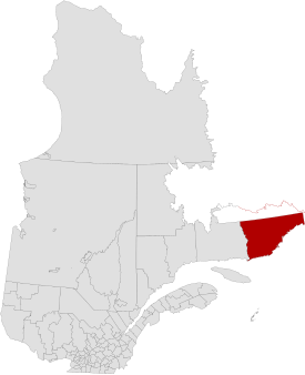
Le Golfe-du-Saint-Laurent
| Municipalité régionale de comté Le Golfe-du-Saint-Laurent
|
|
|---|---|
| Country | Canada |
| province | Quebec |
| Administrative region | Côte-Nord |
| main place | Côte-Nord-du-Golfe-du-Saint-Laurent |
| Residents | 4,348 (2011) |
| surface | 65148.50 km² |
| Population density | 0.07 inhabitants / km² |
| founding | July 7, 2010 |

|
|
Le Golfe-du-Saint-Laurent is a regional county municipality ( French municipalité régionale du comté, MRC ) in the Canadian province of Québec .
It is located in the administrative region of Côte-Nord and consists of six subordinate administrative units (five municipalities and one non-municipality area). The MRC was founded on July 7, 2010 and replaced Basse-Côte-Nord , which did not include unincorporated areas. The main town is Côte-Nord-du-Golfe-du-Saint-Laurent . The population is 4,348 and the area is 65148.50 km², which corresponds to a population density of 0.07 inhabitants per km².
structure
Municipalities (municipalité)
Unincorporated (territoire non-organisé)
The Indian reservations Pakuashipi and La Romaine are also located on the territory of the MRC Le Golfe-du-Saint-Laurent , but they are administered autonomously and form enclaves.
Adjacent MRC and comparable areas
- Mingany
- Division No. 9, Newfoundland and Labrador
- Division No. 10, Newfoundland and Labrador
Web links
Individual evidence
- ↑ Le Golfe-du-Saint-Laurent. Commission de toponymie du Quebec