Thompson (Manitoba)
| Thompson | ||
|---|---|---|
 City Hall |
||
| Location in Manitoba | ||
|
|
||
| State : |
|
|
| Province : | Manitoba | |
| Region: | Northern region | |
| Coordinates : | 55 ° 45 ′ N , 97 ° 51 ′ W | |
| Area : | 17.18 km² | |
| Residents : | 12,829 (as of 2011) | |
| Population density : | 746.7 inhabitants / km² | |
| Time zone : | Central Time ( UTC − 6 ) | |
| Postal code : | R8N | |
| Foundation : | 1956 | |
| Website : | www.thompson.ca | |
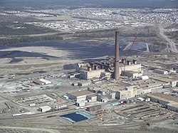
Thompson is a city in Manitoba ( Canada ) and the largest in the north of the province. It is located 739 km north of Winnipeg and 396 km northeast of Flin Flon . According to the 2011 census, Thompson has 12,829 people, down 4.6% from 2006.
history
Thompson's story began on February 4, 1956, when a large ore find was discovered by electromagnetic measurement with an airplane. Another 10 years of exploring the area followed. The company Inco Limited entered into an agreement with the provincial government of Manitoba for the construction of a mine and related facilities, and the acquisition of all public services. The agreement also included financial support from Inco to connect the future city to the railroad near Thicket Portage. Thompson is a planned city and named after Incos' then Chairman John F. Thompson. Thompson received city rights in 1967 and had a population of up to 20,000.
Thompson is also known as "The Hub of the North" as it is the center of politics and trade in the region.
economy
The most important branch of industry is nickel mining and its further processing. Many public offices also have their offices in Thompson. As Manitoba's third-busiest airport , the airport also plays an important role as an employer.
energy
In order to provide electrical energy for the city and industrial companies, the construction of the Kelsey hydropower station around 90 km northeast on the Nelson River began at the same time as the city was built . It was completed in 1961 and is now connected to the city via three power lines with a voltage of 138 KV each .
The Wuskwatim hydropower plant provides additional energy . It is 28 miles southwest of Thompson on the Burntwood River near Taskinigup Falls. Construction began in 2006 and went into operation in 2012. Both power plants are part of the Nelson River Hydroelectric Project .
sons and daughters of the town
- Curtis Leschyshyn (born 1969), ice hockey player
literature
- Bernhard Metz, John R. Rogge: The ore mining in northern Manitoba / Canada - development and current status. In: Erdkunde, Volume 30, 1976, p. 294ff. Available online here , PDF file, 1.13 mb, accessed on January 20, 2016.
- INCO Triangle. Monthly employee magazine with detailed reports on the city, industry and residents. Years up to June 1998 available online searchable here on the Greater Sudbury Museum website . Accessed August 9, 2011. (English)
- WD McRitchie: Mineral Development Potential in Manitoba - Nickel in the Southwest Extension of the Thompson Nickel Belt. Winnipeg 1995. Also includes a detailed listing of the mines and known ore deposits in and around Thompson. Available online on Manitoba's Department of Innovation, Energy and Mines website here , PDF file, 3.2MB. Accessed January 20, 2016. (English)
- Thompson Planning District : Development Plan, June 30, 2013. Available online here , PDF, 6.6MB. Accessed January 20, 2016. (English)
Web links
- Thompson - City website , (English)
- Detailed statistical data on Thompson based on censuses from 1991 and 1996 ( Memento of December 8, 2006 in the Internet Archive ), 2001 and 2006 . (English)
- Thompson Citizen and Nickel Belt News . Weekly newspapers with news and coverage from Thompson and northern Manitoba. (English)
- Reports and articles about Thompson on the Republic of Mining website . (English)
swell
- ↑ Statistics Canada: 2011 Community Profile Thompson. In: Statistics Canada. Retrieved September 17, 2014 .
- ↑ Kelsey Generating Station on the operator's website Hydro Manitoba. Retrieved August 3, 2011.
- ↑ Wuskwatim Generation Project on operator Hydro Manitoba's website, accessed January 20, 2016.

