Churchill (Manitoba)
| Churchill | ||
|---|---|---|
| Location in Manitoba | ||
|
|
||
| State : |
|
|
| Province : | Manitoba | |
| Region: | Northern region | |
| Coordinates : | 58 ° 46 ′ N , 94 ° 10 ′ W | |
| Height : | 10 m | |
| Area : | 53.96 km² | |
| Residents : | 899 (as of May 10, 2016) | |
| Population density : | 16.7 inhabitants / km² | |
| Time zone : | Central Time ( UTC − 6 ) | |
| Postal code : | R0B | |
| Website : | www.churchill.ca | |
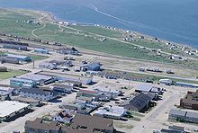
Churchill ( Inuktitut : ᑯᒡᔪᐊᖅ, Kuugjuaq) is a small town with 899 inhabitants (as of 2016) located on the southwest coast of Hudson Bay in the Canadian province of Manitoba . The place is located on the border of two natural zones: the boreal coniferous forest region in the south and the arctic tundra landscape in the north. The city is best known for the many polar bears that migrate from the inland to the coast in autumn and wait for the sea to freeze over to hunt seals, which has earned the place the name of the “polar bear capital of the world”.
history
Archaeological finds show that the area around Churchill and the nearby Wapusk National Park was inhabited by nomadic hunters who belonged to the pre-Dorset culture as early as 4,000 years ago . Their descendants, members of the Dorset culture , settled the region around 600 BC. Around AD 500, Dene came here from the north, followed around AD 1000 by the first representatives of the Thule culture , the immediate ancestors of today's Inuit . In the so-called “pre-contact period” before the arrival of the first Europeans and the appearance of Métis in the 17th century, Inuit, Chipewyan and Cree Indians lived as nomads and in camps in the Churchill region .
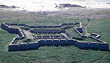
The first Europeans came to the region in the winter of 1619. The Danish captain Jens Munk wintered here in search of the Northwest Passage with two ships and 64 men, only three of whom survived. The first permanently inhabited settlement was a wooden fort built in 1717 at the mouth of the Churchill River - as part of the expensive fur trade network established by the Hudson's Bay Company (HBC) at the time. The city was named after John Churchill, 1st Duke of Marlborough , the governor of the HBC at the end of the 17th century (an ancestor of Sir Winston Churchill ). In 1741 the HBC replaced the wooden fort with a larger stone fort, the Prince of Wales Fort .
This fort was captured and destroyed in 1782 by a French squadron under the command of the later explorer Jean-François de La Pérouse without a shot being fired. A new fort was built a little upstream. During this time, trade was mainly carried out with the Chipewyan who lived north of the boreal coniferous forest, i.e. the tree line . Since the fort was relatively remote from the areas that gave rise to land disputes between the North-West Company and HBC, it was a relatively safe, very profitable fur trading post.
Between the years of the decline in the fur trade and the rise of agriculture (especially grain in the more southern regions of Alberta and Manitoba), Churchill saw its importance dwindle and rise again. After decades of frustration over the supremacy of the Canadian Pacific Railway and false promises by the Canadian National Railway , several provinces joined forces and fought for the construction of a railway line north of Winnipeg to Churchill, the Hudson Bay Railway .
The construction and commissioning of the railway line progressed very slowly due to difficult landscape conditions, so that Churchill only got a connection to the southern railway network in 1929. It then took years before commercial trade could be compared with other places. In 1932 the Briton Grant MacEwan was the first regular rail passenger to visit Churchill.
The area was also used as the Churchill Rocket Research Range , part of a Canadian-American research project that looked at the atmosphere. The first rocket was fired in 1956; until the range was closed in 1984, launches for commercial and research satellites were carried out regularly. Today the "Churchill Northern Studies Center", a facility for Arctic research, is located on the area of the former missile test site.
economy
The usability of Canada's only seaport on the Arctic Ocean is impaired in the winter and spring months, as large amounts of ice tend to accumulate in November on the north coast, which extends from Churchill to Cape Churchill, as large amounts of fresh water come from the numerous rivers that flow between Arviat and Churchill into Hudson Bay and the current in Hudson Bay is counterclockwise. From the port, bulky goods are shipped on supply ships to the arctic north of Canada. Shipments of grain overseas, which used to be a major source of income for the city of Churchill, have declined sharply in recent years, and the port has been closed since summer 2016. Investors are hoping for a renewed upswing as the climate warms.
Unaffected by climatic changes, the tourism industry is still proving to be a robust economic factor for the community. Churchill has been a popular ecotourism destination for years . Tourists can safely watch polar bears from bus- like special vehicles known as tundra buggies , which have been developed for touring the tundra. The best months for polar bear observation are October and especially November. The polar bears then wait in the area from Churchill to Cape Churchill in Wapusk National Park for Hudson Bay to freeze over so that they can hunt their main food, seals. By the way, polar bears can also be observed near Churchill during the summer months; However, beluga whales , all kinds of bird species (including the rare rose gull ) and the abundance of wild plants are particularly attractive .
It is also significant that Churchill is ideal for arctic research because of its excellent infrastructure; Polar bear research in particular benefits from the easy accessibility of the place and the nearby Wapusk National Park.
Traffic situation
There are no roads connecting Churchill to other parts of Canada. In winter the place can only be reached via ice roads .
The city is dependent on its railway connection, the Hudson Bay Railway , which was completed in 1929 , via which the grain exports as well as all other heavy transports take place; Such transports are only possible with restrictions by air. A long-distance train operated by VIA Rail Canada connects Churchill with Winnipeg, some 1,700 kilometers further south, and thus also provides a connection to the rest of the North American rail network.
In the summer of 2016, the railroad tracks south of Churchill were badly damaged; henceforth no trains could run on the route. The Canadian state and Omnitrax , owner of the rails and the port in Churchill since 1997, complained at the end of 2017 in a dispute over who should finance the restoration of the line. At the beginning of September 2018, the railway line was sold to the Canadian consortium Arctic Gateway Group , an investor that is active in the arctic regions of Canada and of which the Canadian state is one of the shareholders. Associated with this was the expectation that the railway line would be restored soon. After the repairs were completed, freight trains have been running to Churchill again since November 2018; VIA Rail resumed passenger traffic on December 2, 2018.
climate
|
Average monthly temperatures and rainfall for Churchill
|
|||||||||||||||||||||||||||||||||||||||||||||||||||||||||||||||||||||||||||||||||||||||||||||||||||||||||||||||||||||||||||||||||||||||||||||||||||||||||||||||||||||||||||||||||||||||||||||||||||||||||||||||||||||||||||||||||||||||||||||||||||||||||||||||
sons and daughters of the town
- Jordin Tootoo (born 1983), Canadian ice hockey player
See also
Web links
- Community profile ( Memento from January 29, 2009 in the Internet Archive )
- http://www.hudsonbaypost.com/ (link not available) - Churchill's Community Newspaper (English)
- Churchill Northern Studies Center (English)
- Churchill on Hudson Bay is also an unusual place by Canadian standards. An online tour in pictures by Anette Schweizer on August 18, 2008
Individual evidence
- ↑ Statistics Canada: Census Profile, 2016 Census: Churchill, Town , accessed January 31, 2019
- ^ A b Karl Felder: A city on the siding . In: Neue Zürcher Zeitung . 23 November 2017, p. 24 ( NZZ online [accessed December 28, 2017]).
- ↑ Canada investing in Arctic Gateway Group. In: ReNew Canada online. September 17, 2018, accessed on September 19, 2018 .
- ^ Freight services back between Churchill and Thompson, Man. CBC, November 25, 2018, accessed November 27, 2018 .
- ^ VIA Rail service resumes in Northern Manitoba, between Gillam and Churchill. VIA Rail, November 27, 2018, accessed November 27, 2018 .


