Fort Prince of Wales
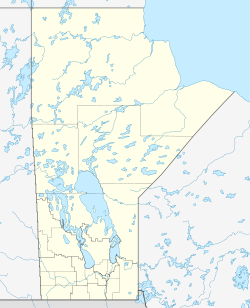
Coordinates: 58 ° 47 '50 " N , 94 ° 12' 48" W The Prince of Wales Fort is a fortification built in 1717 on Hudson Bay in what is now the Canadian province of Manitoba . The reconstruction of the fort from the 1930s is located on the original site of the fortress, so by Churchill as seen across the Churchill River . Militarily and economically, the fortress was a failure, but in the 18th century it influenced the way of life of the Indians there , especially the Cree , and to a lesser extent the Inuit , in a wide area.
history
Jens Munk (1619-1620)
Although the British discovered Hudson Bay as early as 1610 , Jens Munk wintered for the first time from 1619 to 1620 with 61 men at the mouth of the Churchill River. However, his expedition ended in disaster, as no one survived except himself and one man. Only the two men reached Norway , everyone else died of scurvy or trichinae , of hunger and cold. The Europeans avoided the region for half a century.
Hudson's Bay Company, indigenous conflicts, fur trade (from 1689)
However, with the founding of the Hudson's Bay Company in 1670 and a first successful fur trade expedition in 1669, interest in the region rose again. However, they started carefully in the south, at James Bay . This was due to the fact that the British-French rivalry made settlement there extremely risky. The first fort was built in 1689, but it fell victim to a fire. It was not until the Peace of Utrecht (1713) that only the English remained as the only European power to claim the area.
But not only European conflicts hindered trade, but also Indian ones . For example, between 1715 and 1716 an expedition that set out from the York Factory tried to bring about peace between the divided Ojibwa and Cree of the region. This was only possible thanks to the support of Thanadelthur , who was also known as the Slave Woman . She mediated the peace so that the fur trade could begin. These indigenous conflicts were related to the special location of the area on the border between taiga and tundra, with the forests further south still within reach. Three groups with completely different ways of life pervaded it in regular cycles. The Swampy Cree moved between boreal forests and the lowlands on the bay, the Ojibwa or Anishinabe traversed all three ecoregions, and Inuit came from the arctic regions.
The British, for their part, hoped to be able to start direct trade with the areas further west, bypassing New France . In addition, the Indians had contacts very far north.
Churchill River Post (1717)
James Knight of the Hudson's Bay Company had the fort built in 1717 under the name Churchill River Post . It was built from tree trunks. Two years later it was named Prince of Wales Fort , but it is better known as Fort Prince of Wales . It served the company's fur trade , which it was supposed to protect on the Churchill River on the one hand, and on the other hand it was supposed to be a point of contact for indigenous traders from a wide area. Knight himself believed, "York Fort is badd but this is Tenn times worse" (Fort York is bad, but this is ten times worse). Fort York believed that the new fort had no other use than to divert trade from their own fort. It was not until 1725 that it was administered independently of its larger neighbor.
The first stone fortress (from 1732)
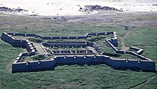
In 1730 the leadership of the Company decided to make the Prince of Wales the central fort for the defense of the Bay region. For this it should be rebuilt in stone. This was all the easier as the great river made it easier to transport bulky goods. The foundation stone was laid on June 3, 1732. Chief Factor Richard Norton estimated the construction time to be six to seven years, which would take four teams of oxen and 84 men. However, the construction time was around 40 years. Its outer walls were 6.5 m high and 11 m thick. An earth ramp was built between the inner and outer walls to allow easy movement within the star-shaped fortress with four bastions at the corners.
Fort York, however, remained two to three times its size in terms of trade. The Prince of Wales was to serve as a refuge for the Company's ships and men. They should also defend the fort together against an attack.
In 1731, the only part of the fortification that still exists today was built. It is located at Eskimo Point. However, the work was never completed. The facility was equipped with 42 cannons, and a battery was added on the other side of the river at Cape Merry. 6 cannons should be set up there. The fort consisted of four bastions connected by long walls.
From 1731 to 1782, numerous whaling and fur hunting or trading expeditions started from here. It was from here that Samuel Hearne and Matonabbee's expedition to the mouth of the Coppermine River (1770–1771) set out. The directors of the fort were well aware that the Swampy Cree who lived around them were enforcing a trade monopoly against other indigenous groups. They came regularly with certain amounts of fur, especially beavers, and were given rifles, ammunition and powder, as well as glass beads and metal goods such as pans or pots. Although the company tried, it never succeeded in increasing its consumption needs by selling toys or music boxes. When the Cree felt no need, they did not come to the fort, so the trade always remained very volatile. This trade was carried out by small groups of hunters who set out for several thousand kilometers and often only returned months later.
The Inuit sat even further away in what is now the Keewatin District . They refused to work as interpreters or even speak to the British when they were captured. They also successfully defended themselves against the sometimes brutal approach. For example, they attacked Henley House , another fort, and they were proud of their independence.
Occupation and extensive destruction by the French (1782–1783)
In 1782, when the fort was manned by only 22 men, Jean-François de La Pérouse led three French warships in front of the fortification. Samuel Hearne recognized the military superiority of the French expedition and handed over the fort without hesitation. However, the fort, which was badly damaged by the French, returned to British hands as early as 1783. Although restored, its importance rapidly declined as the fur trade quickly lost its importance in the area and competing posts emerged. In addition, Pérouse had largely destroyed the fort. He had got rid of the weapons, especially the cannons, undermined the walls and blasted large gaps. He set fires in five places to burn the buildings. It never regained its original meaning, with York Factory becoming the undisputed most important position.
Life in the fort and in the surrounding area
However, the employees were paid relatively well, and the opportunities to circumvent the trade monopoly and thus to gain wealth were apparently quite large. Private traders also made considerable fortunes here.
The diet of the men was designed in such a way that scurvy only rarely occurred. Food from the surrounding Indians contributed to this, such as cranberries , but also the extensive consumption of porter and port wine , which were mixed with malt and berries. Then there was everything that could be hunted, such as buffalo . In winter, however, the accommodations were so smoky that many men preferred to live in Indian tents. The beds were not spread out on the floor, but on a thick layer of pine branches.
Most affected by the fort's existence were the Swampy Cree. They protected and supplied the fort. The company needed contacts to enter into negotiations, to hand out gifts and weapons, to establish contacts. To this end, she awarded honorary titles such as captain or chief to successful hunters . In the Indian power system there were these institutions, such as chief rule , but not at all, if there were also outstanding men. In addition, the British were dependent on the work and knowledge of the Cree. They provided enough warm clothing, snowshoes, adequate health food, caribou meat , and so on. When the caribou herds were absent, the company in turn helped out with flour and other food.
Decline, rail link to Churchill, Parks Canada
By 1850 the decline had advanced so far that only one postal worker remained stationed there. Only the construction of a rail link to Churchill prevented the ghost town from being forgotten. The Historic Sites and Monuments Board of Canada recognized the monumental remains of the wall as of national historical importance, and the Department of the Interior responsible for parks, now Parks Canada, took over the monument.
Remains and restoration
None of the original structures exist anymore. This applies to the large house, which was built from stone, to the district of the governor, to the barracks and the accommodation of the employees, but also to the workshops such as the blacksmith's shop, the tailor's shop, the houses of the carpenters and stone workers. Only the large courtyard is still there, the area is overgrown with grass.
In 1929 the Hudson Bay Railway , the railway connection to Churchill, was completed. Some of the workers were used to rebuild the walls in the years that followed.
Web links
- Michael Payne: "The Healthiest Part in the Known World": Prince of Wales's Fort As Fur Trade Post and Community in the Eighteenth Century , Manitoba Historical Society (originally in the Transactions of the Manitoba Historical Society, Series 3, No. 35, 1978 -79 released)
- Prince of Wales Fort National Historic Site of Canada , Parks Canada


