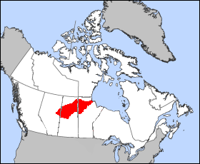
Churchill River (Hudson Bay)
|
Churchill River Rivière Churchill |
||
| Data | ||
| location | Saskatchewan , Manitoba (Canada) | |
| River system | Churchill River | |
| origin |
Churchill Lake 55 ° 49 ′ 6 ″ N , 108 ° 22 ′ 46 ″ W. |
|
| Source height | 421 m | |
| muzzle |
Hudson Bay near Churchill Coordinates: 58 ° 46 ′ 0 ″ N , 94 ° 10 ′ 0 ″ W 58 ° 46 ′ 0 ″ N , 94 ° 10 ′ 0 ″ W. |
|
| Mouth height | 0 m | |
| Height difference | 421 m | |
| Bottom slope | 0.26 ‰ | |
| length | 1609 km | |
| Catchment area | 281,300 km² | |
| Outflow at the estuary level |
MQ |
510 m³ / s |
| Left tributaries | Reindeer River , Little Beaver River , Oldman River | |
| Right tributaries | Beaver River , Smoothstone River , Rapid River , Gauer River , Little Churchill River , Dog River | |
| Flowing lakes | Lac Île-à-la-Crosse , Pinehouse Lake , Sisipuk Lake , Highrock Lake , Granville Lake , Missinipi Lake , Northern Indian Lake | |
| Reservoirs flowed through | Southern Indian Lake | |
| Communities | Sandy Bay | |
| Discharge of 60% of the water to the Nelson River | ||
|
Churchill River basin |
||
|
Derivation of the Churchill River to the Nelson River |
||
The Churchill River (alternative name: Rivière Churchill ) is a 1,609 km long river in the Canadian provinces of Alberta , Saskatchewan and Manitoba .
Since 1977, 60% of the water from the Churchill River has been diverted to the Nelson River - about 760 m³ / s. At the mouth of the Churchill River, only about 510 m³ / s flow on average today.
The river has its origin in Churchill Lake in western Saskatchewan. From there it flows eastward through a series of lakes such as Lac Île-à-la-Crosse , Pinehouse Lake , Highrock Lake , Granville Lake , Southern Indian Lake . It flows into Button Bay in Hudson Bay near Churchill .
However, its catchment area extends far into Alberta via the Beaver River . Other important tributaries are the Rapid River and the Reindeer River .
The amount of water above Red Head Rapids ( ⊙ ) fluctuates between 123 m³ / s (January) and 887 m³ / s (May 2000).
Hydropower plants
The Island Falls hydropower plant, built between 1927 and 1931, now has seven turbines with a total output of 105 MW and is operated by SaskPower . It is east of Lac la Ronge near the Sandy Bay settlement .
Runoff level
- Churchill River at the gauge above Dipper Rapids (1967–1971) - hydrographic data from R-ArcticNET
- Churchill River at the gauge above Granville Falls (1951–2000) - hydrographic data from R-ArcticNET
- Churchill River at the gauge above Leaf Rapids (1973–2000) - hydrographic data from R-ArcticNET
- Churchill River at the gauge above Maple Leaf Rapids (1986–1989) - hydrographic data from R-ArcticNET
- Churchill River at the gauge above Otter Rapids (1963–2000) - hydrographic data from R-ArcticNET
- Churchill River at the gauge above Red Head Rapids (1972–2000) - hydrographic data from R-ArcticNET
- Churchill River at the gauge above Wintego Rapids (1986–1995) - hydrographic data from R-ArcticNET
- Churchill River at Sandy Bay gauge (1928–2000) - hydrographic data from R-ArcticNET
- Churchill River at the gauge below Fidler Lake (1960–2000) - hydrographic data from R-ArcticNET
- Churchill River at the gauge below Trade Lake (1968–1970) - hydrographic data from R-ArcticNET
- Churchill River at Patuanak gauge (1972–1995) - hydrographic data from R-ArcticNET
Web links
Individual evidence
- ↑ The Atlas of Canada - Lakes ( Memento of October 6, 2012 in the Internet Archive ) (English)
- ↑ a b The Atlas of Canada - Rivers ( Memento from January 22, 2013 in the Internet Archive ) (English)
- ^ Natural Resources Canada
- ↑ Churchill River at the gauge above the Red Head Rapids - hydrographic data from R-ArcticNET
- ↑ Hydroelectric Plants in Saskatchewan ( Memento of the original from July 18, 2009) Info: The archive link was automatically inserted and not yet checked. Please check the original and archive link according to the instructions and then remove this notice.


