Winnipeg Beach
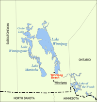
Winnipeg Beach is a small town located in the Interlake region in the Canadian province of Manitoba . The city was founded in 1900 by Sir William Whyte and is located near Highway 9 and Highway 229 southwest of Lake Winnipeg and approximately 35 miles north of the city of Winnipeg . The small town borders the Rural Municipality of Gimli , the Rural Municipality of St. Andrews, and Lake Winnipeg. In 2011 the population was 1,011. The closest small towns are Dunnottar, Gimli, Teulon, Clandeboye, Sandy Hook and Selkirk.
history
In 1900 the Canadian Pacific Railway (CPR) bought 13 acres of vacant land 35 miles north of Winnipeg. A short time later, the construction of the small town began. Several advertising campaigns were launched to promote the settlement. The 3 km long sandy beach was highlighted and various tourist facilities were built. More hotels, a pier and parks followed. In 1913, Winnipeg Beach became so popular that the CPR had to use 13 trains to commute between Winnipeg Beach and the city of Winnipeg. By 1950 the small town's appeal faded. The amusement park was closed in 1964. However, the beach remained a popular destination.
present
After the theme park was closed, the province of Manitoba invested in the city and converted it into a recreational area. In the course of this, several restaurants, hotels and a skateboarding park were built. In addition, larger parking spaces were created in order to have enough capacity in the summer months.
gallery
Web links
Individual evidence
Coordinates: 50 ° 30 ′ N , 96 ° 58 ′ W


