Rivière George
|
Rivière George George River, Kangirsualujjuap Kuunga, Mushuan Shipu, Metsheshu Shipu |
||
|
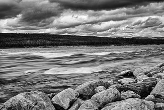
Typical view on Rivière George |
||
| Data | ||
| location | Côte-Nord , Nord-du-Québec in Québec (Canada) | |
| River system | Rivière George | |
| origin |
Lac Jannière 54 ° 51 ′ 30 " N , 63 ° 55 ′ 30" W. |
|
| Source height | 488 m | |
| muzzle | in Ungava Bay , 18 km northwest of Kangiqsualujjuaq Coordinates: 58 ° 49 ′ 0 ″ N , 66 ° 10 ′ 0 ″ W 58 ° 49 ′ 0 ″ N , 66 ° 10 ′ 0 ″ W |
|
| Mouth height | 0 m | |
| Height difference | 488 m | |
| Bottom slope | 0.86 ‰ | |
| length | 565 km | |
| Catchment area | 41,700 km² | |
| Drain |
MQ |
940 m³ / s |
| Left tributaries | Rivière De Pas , Ruisseau Atshakash | |
| Right tributaries | Rivière Dumans , Rivière Déat , Rivière Falcoz , Rivière Gasnault , Rivière Ford | |
| Flowing lakes | Lac Juillet , Lac Elson , Lac Cabot , Lac Resolution , Lac Advance , Lac de la Hutte Sauvage | |
| Communities | Kangiqsualujjuaq | |
|
Rivière George with Pic Pyramid on the right in the Parc national des Monts-Pyramid |
||
|
The catchment area of the Rivière George |
||
The River Rivière George ( English George River ; Kangirsualujjuap Kuunga ("River of the great bay"); Naskapi : Mushuan Shipu ("River without trees"), Metsheshu Shipu ("Eagle River")) is a river in northern Québec in Canada , which flows from Lake Jannière in a predominantly northerly direction to Ungava Bay and crosses the Parc national Ulittaniujalik .
The Rivière George is a large and wide river. It offers relatively easy and inexpensive access to Ungava Bay compared to other larger rivers in the region and is therefore popular for multi-day canoe trips.
geography
The Rivière George has its origin 175 km east of Schefferville in Lac Jannière, in a marshland. The lakes in the upper reaches of the river are shallow and connected by rapids. Below the Lac Advance the river forms rapids until it reaches the Lac de la Hutte Sauvage (Naskapi: Mushuan Nipi ("The great lake in the wasteland")), which stretches for 60 km.
After the Lac de la Hutte Sauvage, the Rivière George really begins to flow. It offers a myriad of rapids of various degrees of difficulty until it reaches Kangiqsualujjuaq near Ungava Bay . Because of its easy accessibility, the river is also used by inexperienced canoe tourists who underestimate the river and risk their lives. The French expression "Fleuve" for stream better describes the character of this river. The climatic conditions favor hypothermia . Canoeists also need to consider the effects of the tides on the last 25 miles of the George.
history
The river received its current name on August 12, 1811 from the two missionaries of the Moravian Brethren, Benjamin Gottlieb Kohlmeister and George Kmoch . These two missionaries first came to Okak in Labrador , and then to Ungava Bay with the vision of converting the Inuit . They gave the river the name of King George III. , King of Great Britain and Ireland , who gave land on the Labrador Coast to this Moravian Brethren in 1769 for permanent settlement.
Web links
Individual evidence
- ↑ a b c d The Atlas of Canada - Rivers ( Memento from January 22, 2013 in the Internet Archive ) (English)
- ↑ FQCK (ed.): Guide des parcours canotables du Québec . Tome II, 2008, ISBN 2-89000-504-6 , pp. 234-235 .
- ↑ Lawrence W. Coady: The Lost Canoe: A Labrador Adventure . 2008, ISBN 978-1-55109-658-2 , pp. 150 .
- ^ Benjamin Kohlmeister, George Kmoch: Journal of a voyage from Okkak, on the coast of Labrador, to Ungava Bay, westward of Cape Chudleigh . London 1814, p. 56 ( Textarchiv - Internet Archive ).
- ↑ Lawrence W. Coady: The Lost Canoe: A Labrador Adventure . 2008, ISBN 978-1-55109-658-2 , pp. 129-130 .


