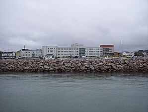
Havre-Saint-Pierre
| Havre-Saint-Pierre | ||
|---|---|---|
 |
||
| Location in Quebec | ||
|
|
||
| State : |
|
|
| Province : | Quebec | |
| Administrative region : | Côte-Nord | |
| MRC or equivalent : | Mingany | |
| Coordinates : | 50 ° 14 ′ N , 63 ° 36 ′ W | |
| Height : | 12 m | |
| Area : | 2 821.65 km² | |
| Residents : | 3150 (as of 2006) | |
| Population density : | 1.1 inhabitants / km² | |
| Time zone : | Eastern Time ( UTC − 5 ) | |
| Municipality number: | 98040 | |
| Foundation : | 1857 | |
| Mayor : | Berchmans Boudreau | |
| Website : | www.havresaintpierre.com | |
Havre-Saint-Pierre is a city in the province of Quebec in Canada . It is located on the northwest bank of the Saint Lawrence River , about 852 km from the city of Québec . The capital of the administrative region Côte-Nord has around 3,150 inhabitants (as of 2006) in two districts.
history
The area around Havre-Saint-Pierre was discovered by the French navigator Jacques Cartier in the mid-16th century . The city itself was founded in 1857 by the then owner of the Magdalene Islands .
population
The city's population is predominantly French-speaking.
Economy and Transport
The main sources of income have been mining and tourism in the Mingan Archipelago National Park since 1984.
The city lies on Route 138 and is connected by a ferry to the opposite bank of the St. Lawrence. The crossing takes about two hours.
Havre-Saint-Pierre is surrounded by a lot of untouched nature in the Canadian state property, in which animals such as black bear , elk , wolf , bald eagle, Canada goose , lynx , caribou , elk , whale and various game fish live in the wild. Fishing , outdoor activities, snowshoeing hiking and skiing are all available to tourists . The snow depth is up to 2 meters in winter.


