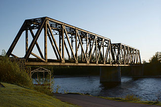
Rivière Métabetchouane
| Rivière Métabetchouane | ||
| Data | ||
| location | Saguenay – Lac-Saint-Jean in Québec (Canada) | |
| River system | Saint Lawrence River | |
| Drain over | La Grande Décharge → Rivière Saguenay → Saint Lawrence River → Atlantic Ocean | |
| origin |
Lac des Mâles and Lac de la Bouteille 47 ° 26 ′ 9 ″ N , 71 ° 41 ′ 7 ″ W |
|
| muzzle | in Lac Saint-Jean near Desbiens Coordinates: 48 ° 25 ′ 15 " N , 71 ° 57 ′ 55" W 48 ° 25 ′ 15 " N , 71 ° 57 ′ 55" W |
|
| Mouth height | 99 m | |
| Height difference | 482 m | |
| Bottom slope | 3.8 ‰ | |
| length | 128 km | |
| Catchment area | 2326 km² | |
| Drain |
MQ |
43 m³ / s |
Rivière Metabetchouane is a 128 km long tributary of Lac Saint-Jean in the center of the Canadian province of Québec .
The river has its origin in the lakes Lac des Mâles and Lac de la Bouteille in the Réserve faunique des Laurentides . From there it flows north to Lac Saint-Jean. The river passes the small town of Saint-André and flows into it at Desbiens on the south bank of Lac Saint-Jean.
The river was dammed for hydropower use. It is also used by tourists - for rafting , canoeing and fishing . The Rivière Metabetchouane is known for its freshwater salmon . In the administrative region of Saguenay – Lac-Saint-Jean this fish is called "ouananiche".
The river name has its origin in the Innu language. However, it also appears to come in part from the Cree and Algonquin languages . The river name can be translated as follows from the two roots of the word matabi and djiwan : river that pours into the lake.
Web links
Individual evidence
- ↑ Natural Resources Canada - The Atlas of Canada - Lakes ( Memento from January 14, 2013 in the Internet Archive )
- ↑ a b c Bureaulösungen publiques sur l'environnement du Quebec (PDF; 103 kB)
- ↑ a b c Commission de toponymie du Québec - Rivière Métabetchouane
