
Montana
| Montana | |||||
|---|---|---|---|---|---|
| |||||
  | |||||
| Capital: | Helena | ||||
| State motto: |
Oro y Plata (spa .: gold and silver ) |
||||
| Official language : | English | ||||
| Surface: | 380,838 km² | ||||
| Residents: | 989,415 (2010 census) (2.5 U / km²) | ||||
| Member since: | November 8, 1889 | ||||
| Time zone: | Mountain : UTC − 7 / −6 | ||||
| The highest point: | 3901 m ( Granite Peak ) | ||||
| Average Height: | 1035 m | ||||
| Deepest point: | 549 m Kootenai River | ||||
| Governor : | Steve Bullock ( D ) | ||||
| Post / Office / ISO | MT / / US-MT | ||||
 | |||||
Montana ( English pronunciation [ mɑnˈtʰænə ] ) is a state in the northwestern United States . The name “Montana” is probably derived from the Spanish word montaña , but perhaps also from the Latin montanus (both in German: “mountain”, “mountainous”, “mountainous”).
With 380,838 km² , Montana is the fourth largest state in the USA after Alaska , Texas and California and slightly larger than Germany . However, with just over a million inhabitants, only about 0.3% of the total population live there. Only Wyoming and Alaska are sparsely populated in the United States . Montana is one of the so-called Mountain States , which are crossed by the Rocky Mountains . The capital of Montana is Helena . Its nickname Treasure State ("State of Treasures") is based on the multitude of mineral resources (oil, coal, copper, silver and gold).
geography
In the north, Montana borders the Canadian provinces of British Columbia , Alberta and Saskatchewan , in the east are the US states of North Dakota and South Dakota , in the south Wyoming and in the southwest and west Idaho . The west of Montana consists of high, rugged mountains ( see Rocky Mountains ), while the east is characterized by wide plains ( see Great Plains ). With an estimated 101,876 residents, Billings is the largest city in Montana. Glacier National Park and a small part of Yellowstone National Park are located in Montana . The Missouri River , Milk River , Flathead River, and Yellowstone River are the four main rivers. The shortest river in the world, the Roe River , also flows through Montana.
structure
The state is divided into 56 individual counties (comparable to the German districts ). The district with the largest population is Yellowstone County in the south of the state with over 129,000 residents .
population
| Population development | |||
|---|---|---|---|
| Census | Residents | ± in% | |
| 1870 | 20,595 | - | |
| 1880 | 39,159 | 90.1% | |
| 1890 | 142.924 | 265% | |
| 1900 | 243,329 | 70.3% | |
| 1910 | 376.053 | 54.5% | |
| 1920 | 548,889 | 46% | |
| 1930 | 537,606 | -2.1% | |
| 1940 | 559.456 | 4.1% | |
| 1950 | 591.024 | 5.6% | |
| 1960 | 674.767 | 14.2% | |
| 1970 | 694,409 | 2.9% | |
| 1980 | 786.690 | 13.3% | |
| 1990 | 799.065 | 1.6% | |
| 2000 | 902.195 | 12.9% | |
| 2010 | 989.415 | 9.7% | |
| Before 1900 1910–2010 |
|||
.svg)
With a good million inhabitants, Montana is one of the most populous states in the USA. In addition, Montana is the third least densely populated state, after Alaska and Wyoming . Since the 1980s, the region has experienced immigration from retirees and nature lovers, while younger people and long-established farming families often migrate.
89% of the population is white (85.9% non-Latin American whites), followed by Native Americans (Indians) at 6.6%. Latin Americans make up 4%.
The 13 Indian tribes are the Kootenai , Blackfoot , Assiniboine , Northern Cheyenne , Salish and Anishinabe , Cree , Pend d'Oreille , Gros Ventre , Chippewa , Sioux , Crow and Little Shell . Around two thirds of them now live on reservations . Between 2000 and 2010, the Native American population grew by 18%.
Indian reservations

There are seven Indian reservations in Montana, divided into twelve tribes. Then there is the Little Shell Tribe , which has no reserve. The reserves are:
- Blackfeet Indian Reservation ( Blackfeet )
- Crow Reservation ( Absarokee )
- Flathead Indian Reservation ( Salish , Pend d'Oreille and Kutenai )
- Fort Belknap Reservation ( Gros Ventre , Assiniboine)
- Fort Peck Indian Reservation ( Dakota , Assiniboine )
- Northern Cheyenne Indian Reservation ( Cheyenne )
- Rocky Boy's Reservation ( Cree , Chippewa )
Religions
The religious communities with the largest number of members in 2000 were the Catholic Church with 169,250, the Evangelical Lutheran Church in America with 50,287 and the Church of Jesus Christ of Latter-day Saints (Mormons) with 32,726 followers.
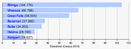
Biggest cities

history
Early history

As the find of the Buhl woman in neighboring Idaho shows, one can expect very early post-glacial inhabitants in the region , who appeared here more than 10,000 years ago. Further south, in Boulder ( Colorado ), was found in 2008 83 Tools in May that are about 13,000 years old. The oldest sites in the state include Indian Creek, Mill Iron, and Myers-Hindman. Indian Creek, a temporarily inhabited camp, is around 11,000 years old, Mill Site, a hunting and dining area that is probably only used once, around 10,700 years old, and Myers-Hindman, a permanent camp around 9,000 years old. The Barton Gulch Site in southwest Montana belongs to the late Paleo-Indian era.
A sparse settlement took place here and east of the Rocky Mountains during the following archaic phase (6000 BC - 500 AD) . This phase is characterized by increasing drought. Early wickiups were made around 3000 BC. Ousted by tipis . The atlatl was used for hunting and was replaced by a bow and arrow around 500. Buffalo jumps increased, as did the concentration on the bison known as buffalo , which were plunged into the depths in such places. Such spots can be found at the Madison Buffalo Jump or at Ulm Pishkun . Not until 1730 did the horse increasingly replace the dog as a transport animal, although the travois was retained as a simple means of transport.
The Indian tribes now resident in Montana immigrated relatively late. Most of them originally lived much further east. Some of them went through very complicated hikes. This is how the Kutenai lived east of the Rocky Mountains. According to oral tradition, they lived on Lake Michigan around 600 years ago . They moved to the Tobacco Plains on the Kootenai River in Montana and British Columbia . The group split into an upper one, the Upper Kutenai, whose way of life was heavily influenced by buffalo hunting, whereas the Lower Kutenai became sedentary. The Jennings Band or Agiyinik, which was one of the Upper Kutenai, formed a tribe of around 700 members around 1850. They first lived around Jennings in Montana, migrated eastwards to the area of what later became Kalispell , then southwards to Elmo . One group that Libby Montana moved to the Fort Steele area of British Columbia. Before 1855, the Libby and Jenning Band moved to Upper Flathead Lake in Montana.
One of the first groups to move westward was arguably the Blackfoot , even if they did not become equestrian nomads until around 1730. Their culture can probably be traced back to the 8th century.
The Salish or Flathead , who belong to the inland Salish , came from the west, where their relatives, the coastal Salish , lived mainly from fishing. The Salish groups living in the hinterland also had to adapt culturally to the dry landscape and became equestrian nomads just like their neighbors.
The Absarokee did not come to Montana until the 18th century, also from the Great Lakes, in the south of which they lived. However, their area extended much further south. However, the area around Billings was already inhabited around 2100 years ago. The Absarokee (Apsáalooke), known as Crow in Montana, probably had the largest herds of horses and in 1914 owned around 30 to 40,000 animals.
The Cheyenne were also ousted by the Anishinabe in the 18th century and moved to Dakota and Colorado.
The same happened to the Sioux , who had probably been pushed west by the Iroquois from around 1650 , and the Gros Ventre , who came to Montana around 1800, displaced by the Cree . The Assiniboine are a Lakota tribe that split off in the 17th century and was probably also displaced westward by the Iroquois.
With the exception of the early immigrants, what all groups have in common is that they have been ousted by tribes that have been armed with weapons in exchange for fur from Europeans. The settlement of Montana is an unwanted long-range effect of European trade.
First European
The two traders Louis-Joseph Gaultier de La Vérendrye and François de La Vérendrye were the first Europeans to reach what is now Montana in 1743.
On April 30, 1803, the United States acquired the French Louisiana , to which the later Montana also belonged. The Lewis and Clark Expedition drove down the Columbia River to the Pacific coast, where they spent the winter from 1805 to 1806. Meriwether Lewis mapped the Marias River on the return trip . William Clark left his name on July 25, 1806 at Pompeys Pillar around 40 km northeast of Billings. Lewis' group of four encountered Blackfeet, but two of them were killed in a gun fight. Clark entered the Crow area meanwhile. Without seeing a single one of them, they stole some horses from them.
Gold rush and population growth
In 1846, as part of the Oregon Compromise , Great Britain ceded northwest Montana to the USA, which was part of the Dakota Territory from 1861 to 1864 . In 1862 the gold rush began in Grasshopper Creek and later in Virginia City and attracted thousands to the sparsely populated area; the Indians had previously been forced into reservations. Montana became an independent territory as early as 1864, and Virginia City was the capital until 1875.
Fort Shaw was built west of Great Falls by order of Congress in 1867. Other posts were Camp Cooke on the Judith River and Fort CF Smith on the Bozeman Trail . Fort Shaw could accommodate up to 450 soldiers and guarded the supply line to Fort Benton until 1891 .
Wars between the USA and the Indians
The Battle of Little Bighorn , at the end of June 1876 in Eastern Montana, a cavalry unit of 257 men under George Armstrong Custer of Lakota, Arapaho and Cheyenne was wiped out, resulted in many Cheyenne later deported south. But some of them returned to Montana under Little Wolf. 1877 attracted Nez Perce on their escape from the troops of the American army through Montana and the border were stopped to Canada and forced to give up the south in the Bear Paw Mountains.
On the Canadian side, the Métis under Louis Riel defended themselves against their displacement until 1884. Some of them had moved to Dakota as early as 1850. After the failure of the uprising, numerous Canadian Métis came to Montana, but because they were not Indians but mixed race in the eyes of the government, they were not given a reservation. This still affects the Little Shell tribe to this day .
From territory to state
Between 1864 and 1889, Montana was organized as a territory . It arose from the remodeling of the greater Idaho Territory . In its first year as a territory , Bannack was the capital. However, it was replaced by Virginia City as Capitol City in 1865 . In 1875 the capital was moved to Helena . The admission as a federal state in the USA took place in 1889 - Montana became the 41st state.

Attitudes towards the buffalo changed as well as towards the preservation of the ecological characteristics of the state. In 1908 the National Bison Range in western Montana was the first protected area ; In 1910 the Glacier National Park was founded on the drastically reduced area of the Blackfeet .
In 1917, Republican Jeannette Rankin became the first woman to serve in the United States House of Representatives .
In 1973, Montana received a new constitution.
In 1988, the country was hit by the worst drought since the 1930s.
politics
The governor is the head of government, is elected every four years by eligible voters and can be re-elected an unlimited number of times, although only two consecutive terms of office are possible. More specific elective posts are those of the Lieutenant Governor ( lieutenant governor ), the Minister of State ( Secretary of State ), the Attorney General ( Attorney General ), the Minister of Education ( Superintendent of Public Instruction ) and the auditor ( auditor ). The current governor is Steve Bullock (born 1966, Democrat ).
The Montana Senate (50 members elected for four years) and the Montana House of Representatives (100 members elected for two years) together form the bicameral system of the legislature . At the national level, Montana is represented by two senators and one member of the House of Representatives. As a sparsely populated state, Montana only has three electoral votes in the presidential election . The two current US Senators from Montana are Democrat Jon Tester and Republican Steve Daines . The US House of Representatives is Republican Greg Gianforte .
In the November 4, 2008 presidential election, 242,763 citizens of Montana voted for Republican presidential candidate John McCain , while 231,667 voters voted for the federally victorious Democrat Barack Obama . Thus, the three electoral votes of Montana went to John McCain and Sarah Palin . In the November 6, 2012 presidential election , 267,928 citizens of Montana voted for Republican presidential candidate Mitt Romney , while 201,839 voters voted for the federally victorious Democrat Barack Obama. Thus, the three Montana electoral votes went to Mitt Romney and Paul Ryan . In the presidential election on November 8, 2016, 279,240 citizens of Montana voted for victorious Republican presidential candidate Donald Trump , while 177,709 voters voted for Democrat Hillary Clinton . The three electoral votes of Montana went to Donald Trump and Mike Pence . The last Democrat to win the state was Bill Clinton in the 1992 presidential election . Traditionally, in Montana, Republicans tend to be preferred in presidential and gubernatorial elections, while Democrats get more votes in congressional elections. Outstanding political figures from Montana were Mike Mansfield (1903–2001) and Jeannette Rankin (1880–1973). Mansfield was from 1961 to 1977 the Democratic majority leader in the US Senate and later US ambassador to Japan . Rankin was the first woman to be elected to the House of Representatives; there she consistently represented her pacifist position and voted against the USA's entry into the war both during the First and Second World Wars .
Governors
congress
- List of United States Senators from Montana
- List of members of the US House of Representatives from Montana
Culture and sights
Montana's standout attraction is Glacier National Park . Around 80 percent of foreign park visitors come to Montana specifically for the park, and tourists who visit Montana for the outdoors stay longer and spend more money in the state than all other visitors. There is also Yellowstone National Park on the state's southern border , three percent of which is in Montana. Other tourist attractions include the Little Bighorn Battlefield National Monument , the former capital of Montana Virginia City , the ghost town of Nevada City , Grant-Kohrs Ranch National Historic Site, and the Museum of the History of the Plains Indian in Browning .
National parks
| National park | location | view |
|---|---|---|
Glacier National Park (United States)
|

|

|
|
Yellowstone National Park
Commons : Yellowstone National Park Pictures
|
|

|
Natural and cultural monuments
Because of its low population density, Montana has many natural parks and state parks .
- Big Hole National Battlefield
- Bighorn Canyon National Recreation Area
- Grant-Kohrs Ranch National Historic Site
- Lewis & Clark National Historic Trail
- Little Bighorn Battlefield National Monument
- Pompeys Pillar National Monument
- Upper Missouri River Breaks National Monument
Sports
Sports popular in the United States, such as baseball, are also played in Montana, and there are a number of teams that play in the minor league . Natural or outdoor sports such as hiking, fishing, hunting and climbing are of great importance . Skiing is popular in winter. There are 16 ski areas; the two most famous are the Bridger Bowl near Bozeman and the Red Lodge Mountain Resort near Red Lodge.

Big Sky resort
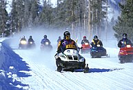
Snowmobiling in Yellowstone Park
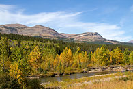
Autumn landscape

Bighorn Canyon National Recreation Area


.jpg)

Economy and Infrastructure
Real gross domestic product per capita GDP - the most important indicator of prosperity - was USD 44,118 in 2016 (national average of the 50 US states: USD 57,118; national ranking: 43). The unemployment rate was 4.0% in November 2017 (national average: 4.1%).
Montana is rich in mineral and other natural resources. The most important raw material deposits include copper , gold , silver , precious stones , vermiculite , talc , clay , antimony , limestone , phosphate , gypsum , stones , sand and gravel . However, many mines are now exhausted. The Butte Copper Mine closed in 1983 and resulted in one of the largest mining remediation projects in the United States. The copper smelter in Anaconda ceased operations in 1980. Many workers in mining and industry lost their jobs as a result, and Montana tended to become a low-wage region .
The deposits of crude oil , natural gas and coal are of great importance today . The majority of industrial production is based on the processing of the extracted raw materials (petroleum and coal products, ore smelting, chemical products, metal products). The agriculture but is the most important source of income. Wheat , corn and barley are grown in the northeast and central Montana , while cattle and livestock are raised in the south . Wine is also grown . There are numerous small breweries . Forestry is particularly flourishing in the north-west of the country, although large parts of the commercial forests are in state hands.
Many farms have been split up and sold as vacation homes or second homes over the past few decades . The tourism (with golf courses , winter sports , hunting and fishing ) plays an increasingly important role since the 1980s.
traffic
Streets
The main road links are Interstate 90 and Interstate 94, and US Routes 2 and 12 .
railroad
In 1883 the continental east-west connection of the Northern Pacific Railroad , which runs through Billings, was completed. The route is now used by the freight trains of the BNSF Railway .
air traffic
One international airport, Billings Logan International Airport , is located in Billings . The second largest airport in the state is Bozeman Yellowstone International Airport .
education
The most important state universities are grouped together in the Montana State University System with its main location in Bozeman and the University of Montana System with its main location in Missoula . Additional universities are included in the list of universities in Montana .
military
150 Minuteman III nuclear ICBMs of the 341st Missile Wing ( US Air Force ) are stationed on the territory of the state and are in constant readiness. The headquarters are at Malmstrom Air Force Base .
Others
The flag of Montana shows the state's seal on a blue background. It originated from a troop flag originally used by volunteer organizations in the Spanish-American War of 1898. The flag in its current form dates from 1905, but the name "Montana" was not added until 1981.
After the state is Montana-class battleship of the US Navy named.
Official symbols
The official symbols of Montana are:
| symbol | Illustration | Recording as a symbol | annotation | |
|---|---|---|---|---|
| seal | Seal of Montana |
 |
1865 | |
| flag | Flag of Montana |
 |
Used as a troop flag by volunteer organizations from Montana in the Spanish-American War of 1898. Adopted as the state flag in 1905. The word "Montana" above the seal was added in 1981. In 1985 the font of "Montana" was determined. | |
| motto |
Oro y Plata (Gold & Silver) |
- | German: gold and silver | |
| flower |
Bitterroot Lewisia rediviva |
 |
||
| mammal |
Grizzly bear Ursus arctos horribilis |
 |
||
| bird |
Western Meadowlark Sturnella neglecta |
.jpg) |
||
| fish |
Blackspotted Cutthroat Trout Oncorhynchus clarkii lewisi |
.jpg) |
||
| Gemstones | Sapphire and agate |
 |
||
| Soil type | Scobey | - | The Scobey soil type is found in the "Golden Triangle" between the cities of Great Falls , Havre and Conrad . |
Web links
- Official website of the state of Montana. Retrieved December 3, 2010 .
- Official Tourism Website (English)
- Information about Montana on the website of the Montana Historical Society (English)
- Indian Montana's website (English)
Individual evidence
- ^ Density Using Land Area on census.gov
- ↑ a b "About Montana" on mt.gov. Retrieved January 14, 2020
- ↑ a b c https://www.census.gov/quickfacts/fact/table/MT,US/PST045219
- ↑ Figures from the United States Census Bureau , accessed September 10, 2008.
- ^ US Census Bureau _ Census of Population and Housing . Retrieved February 28, 2011.
- ↑ https://www.census.gov/data/tables/2010/dec/apportionment-data-text.html
- ↑ https://www.census.gov/quickfacts/fact/table/MT,US/PST045217
- ↑ United States by States; and Puerto Rico - GCT-PH1. Population, Housing Units, Area, and Density: 2000
- ^ A b Montana Indians: Their History and Location. From: opi.mt.gov (Office of Public Instruction), 2010. Accessed January 14, 2020 (PDF).
- ^ Montana Governor's Office of Indian Affairs: tribalnations
- ^ The Association of Religion Data Archives | Maps & Reports ( Memento from January 25, 2012 in the Internet Archive )
- ^ Alysia Patterson, 13,000-year-old tools unearthed at Colorado home , Feb. 26, 2009.
- ^ LB Davis, ST Greiser: Indian Creek Paleoindians: Early Occupation of the Elkhorn Mountains' Southeastern Flank, West-Central Montana. in: Ice Age Hunters of the Rockies. Ed. DJ Stanford, JS Day, Denver Museum of Natural History and University Press of Colorado 1992, 225-283.
- ^ GC Frison: The Mill Iron Site. University of New Mexico Press, Albuquerque 1996.
- ↑ LA Lahren: The Myers-Hindman Site: An Exploration Study of Human Occupation Patterns in the Upper Yellowstone Valley from 7000 BC to AD 1200. Unpublished Diss., University of Calgary, Archeology Department 1976.
- ↑ Joe Medicine Crow: The Migration Story. and Rick Graetz, Susie Graetz: Migration: Another Version. from: Rick Graetz, Susie Graetz: Crow Country: Montana's Crow Tribe of Indians. Billings: Northern Rockies Publishing Company, 2000.
- ^ Website of the National Bison Range Wildlife Refuge
- ^ Norma Nickerson: What the People think - Glacier National Park and Vicinity (PDF; 169 kB) . University of Montana, Institute for Tourism & Recreation Research, May 2003, p. 7 f .; Neal Christensen, Norma Nickerson: Three Communities Explore Tourism (PDF; 142 kB) . University of Montana, Institute for Tourism & Recreation Research, September 1996, p. 11
- ^ Montana Guidebook. (PDF) Retrieved March 26, 2016 (tourism advertising brochure of the Montana Office of Tourism, Department of Commerce).
- ^ US Department of Commerce, BEA, Bureau of Economic Analysis: Bureau of Economic Analysis. Retrieved August 27, 2017 (American English).
- ^ Unemployment Rates for States. Retrieved January 8, 2018 .
- ↑ Jared Diamond, Collapse , 2nd ed., Penguin Books 2011, p. 37 f.
States:
Alabama |
Alaska |
Arizona |
Arkansas |
Colorado |
Connecticut |
Delaware |
Florida |
Georgia |
Hawaii |
Idaho |
Illinois |
Indiana |
Iowa |
California |
Kansas |
Kentucky |
Louisiana |
Maine |
Maryland |
Massachusetts |
Michigan |
Minnesota |
Mississippi |
Missouri |
Montana |
Nebraska |
Nevada |
New Hampshire |
New Jersey |
New Mexico |
New York |
North Carolina |
North Dakota |
Ohio |
Oklahoma |
Oregon |
Pennsylvania |
Rhode Island |
South Carolina |
South Dakota |
Tennessee |
Texas |
Utah |
Vermont |
Virginia |
Washington |
West Virginia |
Wisconsin |
Wyoming
Federal District:
Washington, DC
External Areas:
American Samoa |
American Virgin Islands |
Baker Island |
Guam |
Howland Island |
Jarvis Island |
Johnston Atoll |
Kingman attack |
Midway Islands |
Navassa |
Northern Mariana Islands |
Palmyra Atoll |
Puerto Rico |
Wake up
List of counties in Montana
Beaverhead |
Big Horn |
Blaine |
Broadwater |
Carbon |
Carter |
Cascade |
Chouteau |
Custer |
Daniels |
Dawson |
Deer Lodge |
Fallon |
Fergus |
Flathead |
Gallatin |
Garfield |
Glacier |
Golden Valley |
Granite |
Hill |
Jefferson |
Judith Basin |
Lake |
Lewis and Clark |
Liberty |
Lincoln |
Madison |
McCone |
Meagher |
Mineral |
Missoula |
Musselshell |
Park |
Petroleum |
Phillips |
Pondera |
Powder River |
Powell |
Prairie |
Ravalli |
Richland |
Roosevelt |
Rosebud |
Sanders |
Sheridan |
Silver Bow |
Stillwater |
Sweet Grass |
Tetons |
Toole |
Treasure |
Valley |
Wheatland |
Wibaux |
Yellowstone
Coordinates: 47 ° 0 ′ N , 110 ° 0 ′ W