Gallatin County, Montana
![The Gallatin County Courthouse in Bozeman, listed on the NRHP since 1987 [1]](https://upload.wikimedia.org/wikipedia/commons/thumb/f/fd/Looking_NW_at_Gallatin_County_Courthouse_003_-_Bozeman_Montana_-_2013-07-09.jpg/298px-Looking_NW_at_Gallatin_County_Courthouse_003_-_Bozeman_Montana_-_2013-07-09.jpg) The Gallatin County Courthouse in Bozeman, listed on the NRHP since 1987 |
|
| administration | |
|---|---|
| US state : | Montana |
| Administrative headquarters : | Bozeman |
| Address of the administrative headquarters: |
Gallatin County Courthouse 311 West Main Street Bozeman, MT 59715-4594 |
| Foundation : | 1864 |
| Area code : | 001 406 |
| Demographics | |
| Residents : | 89,513 (2010) |
| Population density : | 13.3 inhabitants / km 2 |
| geography | |
| Total area : | 6816 km² |
| Water surface : | 67 km² |
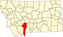
| map | |
| Website : www.gallatin.mt.gov | |
The Gallatin County is a county in the US -amerikanischen State Montana . In 2010 , the county had 89,513 residents and a population density of 13.3 people per square kilometer. By 2013 the population increased to 94,720. The county seat is in Bozeman .
geography
Gallatin County is located in southwest Montana at the intersection of the three states of Montana, Idaho and Wyoming . The county has an area of 6,816 square kilometers, spread over 6,750 square kilometers of land and 67 square kilometers of water.
In Gallatin County is the origin of the Missouri with the confluence of the Jefferson River and Madison River .
The following neighboring counties border Gallatin County:
| Jefferson County | Broadwater County | Meagher County |
| Madison County |

|
Park County |
| Fremont County, Idaho |
Park County Teton County |
Protected areas
- Yellowstone National Park (partially)
- Gallatin National Forest (partially)
history
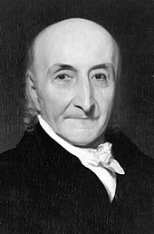
Gallatin County was founded in 1864 in what was then the Dakota Territory . It was named after the former US Treasury Secretary Albert Gallatin (1761–1849)

In 1873 came with the Lost Dakota called area on the border with Idaho and Wyoming, which was an exclave of the Dakota Territory until then, Gallatin County and thus Montana.
One place in the county has the status of a National Historic Landmark , the Three Forks of the Missouri . 104 structures and sites in the county are registered in the National Register of Historic Places (as of February 8, 2018).
population
| Population development | |||
|---|---|---|---|
| Census | Residents | ± in% | |
| 1870 | 1578 | - | |
| 1880 | 3643 | 130.9% | |
| 1890 | 6246 | 71.5% | |
| 1900 | 9553 | 52.9% | |
| 1910 | 14,079 | 47.4% | |
| 1920 | 15,864 | 12.7% | |
| 1930 | 16,124 | 1.6% | |
| 1940 | 18,269 | 13.3% | |
| 1950 | 21,902 | 19.9% | |
| 1960 | 26,045 | 18.9% | |
| 1970 | 32.505 | 24.8% | |
| 1980 | 42,865 | 31.9% | |
| 1990 | 50,463 | 17.7% | |
| 2000 | 67,831 | 34.4% | |
| 2010 | 89,513 | 32% | |
| 2013 estimate | 94,720 | 5.8% | |
| Before 1900 1900–1990 2000 2010–2013 | |||
According to the 2010 census , Gallatin County had 89,513 people in 36,659 households. The population density was 13.3 inhabitants per square kilometer. Statistically, 2.34 people lived in each of the 36,659 households.
The racial the population was composed of 95.4 percent white, 0.4 percent African American, 1.0 percent Native American, 1.3 percent Asian, 0.1 percent Polynesian and other ethnic groups; 1.7 percent were descended from two or more races. Hispanic or Latino of any race was 3.1 percent of the population.
20.7 percent of the population were under 18 years old, 68.5 percent were between 18 and 64 and 10.8 percent were 65 years or older. 48.5 percent of the population were female.
The median income for a household was 52,211 USD . The per capita income was $ 28,642. 13.3 percent of the population lived below the poverty line.
Places in Gallatin County
Census-designated places (CDP)
1 - partially in Madison County
structure
Gallatin County is divided into eight Census County Divisions (CCD):
| CCD | Population (2010) | FIPS |
|---|---|---|
| Belgrade CCD | 23,200 | 30-90189 |
| Big Sky CCD | 2195 | 30-90305 |
| Bozeman CCD | 49,560 | 30-90420 |
| Gallatin Gateway CCD | 4839 | 30-91344 |
| Manhattan CCD | 4848 | 30-92226 |
| Three Forks CCD | 3098 | 30-93528 |
| West Yellowstone CCD | 1758 | 30-93780 |
| Yellowstone National Park CCD | 15th | 30-94017 |
Individual evidence
- ↑ Extract from the National Register of Historic Places - No. 87001794.Retrieved July 18, 2014
- ↑ GNIS-ID: 1720053. Retrieved on February 22, 2011 (English).
- ↑ a b c U.S. Census Bureau, State & County QuickFacts - Gallatin County, MT ( Memento of the original from July 10, 2011 on WebCite ) Info: The archive link was automatically inserted and not yet checked. Please check the original and archive link according to the instructions and then remove this notice. Retrieved July 18, 2014
- ↑ a b National Association of Counties.Retrieved July 18, 2014
- ^ NPR - Beyond 50: American States That Might Have Been Retrieved July 18, 2014
- ↑ Listing of National Historic Landmarks by State: Montana . National Park Service , accessed February 8, 2018.
- ↑ Search mask database in the National Register Information System. National Park Service , accessed February 8, 2018.
- ^ US Census Bureau - Census of Population and Housing.Retrieved March 15, 2011
- ^ Extract from Census.gov.Retrieved February 18, 2011
- ↑ Missouri Census Data Center - Montana ( page no longer available , search in web archives ) Info: The link was automatically marked as defective. Please check the link according to the instructions and then remove this notice. Retrieved July 18, 2014
Web links
Coordinates: 45 ° 34 ′ N , 111 ° 10 ′ W


