Silver Bow County
 Silver Bow County US Courthouse and Mike Mansfield Federal Building |
|
| administration | |
|---|---|
| US state : | Montana |
| Administrative headquarters : | Butte |
| Foundation : | 1881 |
| Demographics | |
| Residents : | 34,200 (2010) |
| Population density : | 18.4 inhabitants / km 2 |
| geography | |
| Total area : | 1862 km² |
| Water surface : | 2 km² |
| map | |
| Website : co.silverbow.mt.us | |
Silver Bow County is the smallest county in the state of Montana in the United States . The county seat is in Butte .
Demographic data
| growth of population | |||
|---|---|---|---|
| Census | Residents | ± in% | |
| 1890 | 23,744 | - | |
| 1900 | 47,635 | 100.6% | |
| 1910 | 56,848 | 19.3% | |
| 1920 | 60,313 | 6.1% | |
| 1930 | 56,969 | -5.5% | |
| 1940 | 53.207 | -6.6% | |
| 1950 | 48,422 | -9% | |
| 1960 | 46,454 | -4.1% | |
| 1970 | 41,981 | -9.6% | |
| 1980 | 38.092 | -9.3% | |
| 1990 | 33,941 | -10.9% | |
| 2000 | 34,606 | 2% | |
| 2010 | 34,200 | -1.2% | |
| Before 1900 1900–1990
2000 + 2010 |
|||
The county had 34,606 people as of the 2000 census . There were 14,432 households and 8,933 families. The population density was 19 inhabitants per square kilometer. The racial the population was composed of 95.35% White, 0.16% African American, 2.03% Native American, 0.43% Asian, 0.06% Pacific Islander, and 0.59% other races Groups; 1.37% were from two or more races. 2.75% of the population were Hispanic or Latino of any race.
Of the 14,432 households, 28.00% had children and adolescents under the age of 18 living with them. 47.80% were married couples living together, 10.50% were single mothers. 38.10% were not families. 32.80% were single households and 13.70% had someone who was 65 years of age or older. The average household size was 2.32 and the average family size was 2.97 people.
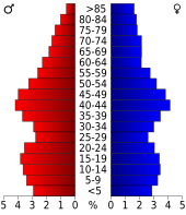
For the entire county, the population was composed of 23.70% residents under 18 years of age, 9.60% between 18 and 24 years of age, 26.70% between 25 and 44 years of age, 24.00% between 45 and 64 years of age 16.00% were 65 years of age or over. The median age was 39 years. For every 100 females there were 97.80 males, for every 100 females aged 18 and over there were 96.30 males.
The median income for a household in the county is $ 30,402 , and the median income for a family is $ 40,018. Males had a median income of $ 31,295 versus $ 21,610 for females. The per capita income was $ 17,009. 14.90% of the population and 10.70% of families are below the poverty line. 19.20% of these were under 18 years of age and 8.90% were 65 years of age or older.
history
Two places in the county have National Historic Landmark status , the Butte-Anaconda Historic District and the Burton K. Wheeler House . 17 buildings and sites in the county are listed on the National Register of Historic Places (as of February 9, 2018).
The county's voters have voted for the Democratic candidate in every presidential election since the 1956 election , while Montana as a whole has mostly been won by the Republicans .
Places in Silver Bow County
Web links
Individual evidence
- ↑ GNIS-ID: 1719575. Retrieved on February 22, 2011 (English).
- ↑ US Census Bureau - Census of Population and Housing . Retrieved March 15, 2011
- ↑ Extract from Census.gov . Retrieved February 18, 2011
- ↑ Extract from census.gov (2000 + 2010) Retrieved April 13, 2012
- ↑ Listing of National Historic Landmarks by State: Montana . National Park Service , accessed February 9, 2018.
- ↑ Search mask database in the National Register Information System. National Park Service , accessed February 8, 2018.
- ↑ Sean Trende: Sizing Up the Montana Senate Race. In: RealClearPolitics , September 26, 2018.
Coordinates: 45 ° 54 ′ N , 112 ° 40 ′ W

