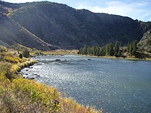
Madison River
| Madison River | ||
|
Upper reaches of the Madison River in Yellowstone National Park |
||
| Data | ||
| Water code | US : 801119 | |
| location | Wyoming , Montana (USA) | |
| River system | Mississippi River | |
| Drain over | Missouri River → Mississippi River → Gulf of Mexico | |
| origin | Confluence of the Firehole and Gibbon Rivers 44 ° 38 ′ 32 ″ N , 110 ° 51 ′ 56 ″ W |
|
| Source height | 2071 m | |
| confluence | with the Jefferson River to Missouri Coordinates: 45 ° 55 ′ 39 " N , 111 ° 30 ′ 29" W 45 ° 55 ′ 39 " N , 111 ° 30 ′ 29" W |
|
| Mouth height | 1232 m | |
| Height difference | 839 m | |
| Bottom slope | 2.9 ‰ | |
| length | 294 km | |
| Flowing lakes | Earthquake Lake | |
| Reservoirs flowed through | Hebgen Lake , Ennis Lake | |
The Madison River is a river in the US states of Wyoming and Montana . It belongs to the Missouri - Mississippi river system and is one of the headwaters of the Missouri , along with the Jefferson River . The Madison River was named by Lewis and Clark in 1805 in honor of the then Secretary of State and later US President James Madison .
The Madison River is 294 km long and arises from the confluence of the Firehole River and Gibbon River in the west of Yellowstone National Park in the state of Wyoming. The Firehole River coming from the south and the Gibbon River coming from the east unite north of the Firehole Canyon to form the Madison River. From here it flows to the west and widens within the national park around the state border with Montana in the Madison Valley . The course of the river at the west entrance to the park is an important breeding area for water birds such as various limikoles and the trumpeter swan .
It is dammed outside the park below West Yellowstone from Hebgen Dam to Hebgen Lake . After an earthquake in 1959, a natural lake called Earthquake Lake formed below the reservoir . The Madison River turns north at its outflow and is dammed again at Ennis from Madison Dam to Ennis Lake . The river continues north through Bear Calf Canyon , which is designated as part of the Lee Metcalf Wilderness , a wilderness area and thus the strictest class of nature reserve in the United States. The river is also a popular here whitewater - Kayak -Revier. Seven kilometers northeast of the village of Three Forks , the Madison River in Missouri Headwaters State Park forms the Missouri through its confluence with the Jefferson River .
Between Madison and Gallatin Rivers lies the Madison Range in north-south direction , a mountain range of the Rocky Mountains with Hilgart Peak (3449 m) as the highest point. The Madison River valley also separates the Gallatin National Forest east of the river from Beaverhead National Forest west. Both are national forests under the administration of the US Forest Service . The US Highway 287 extends from the exit from the Yellowstone National Park to the confluence parallel to the flow and from there further to the north.
Web links
- Madison River in the Columbia Gazetteer
Individual evidence
- ↑ Madison Range on Peakbagger.com , accessed August 31, 2019

