Firehole River
| Firehole River | ||
|
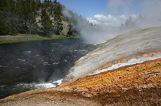
Drainage from the pot of a geyser into the Firehole River |
||
| Data | ||
| Water code | US : 1588484 | |
| location | Teton County , Wyoming , United States | |
| River system | Mississippi River | |
| Drain over | Madison River → Missouri River → Mississippi River → Gulf of Mexico | |
| source | in the caldera of the Yellowstone volcano, 44 ° 20 ′ 37 ″ N , 110 ° 52 ′ 43 ″ W |
|
| confluence | with the Gibbon River to the Madison River Coordinates: 44 ° 38 ′ 32 " N , 110 ° 51 ′ 56" W 44 ° 38 ′ 32 " N , 110 ° 51 ′ 56" W
|
|
| length | 45 km | |
|
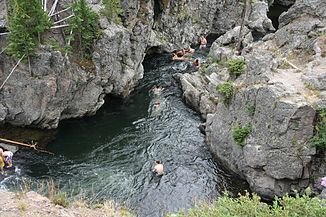
Bathing in Firehole Canyon |
||
The Firehole River is a river in the southwest of Yellowstone National Park in the United States . It belongs to the Missouri - Mississippi river system as the source river of its longest branch.
The river rises on the North American continental divide in the interior of the caldera of the Yellowstone volcano and runs in a northerly direction 45 km to the confluence with the Gibbon River , with which it then forms the Madison River . The Firehole River passes the Upper Geyser Basin with the Old Faithful , one of the most famous geysers on earth, as well as four other smaller geyser basins and a number of other geothermal areas, the runoff of which it takes up. Shortly before the confluence, the river passes the Firehole Canyon with the Firehole Falls , waterfalls in the canyon . Other, smaller waterfalls are the Keppler Cascades on the upper reaches. Notable tributaries are the Little Firehole River and Fairy Creek on the left , both of which drain the caldera rim in the area of the Madison Plateau , and on the right, the Nez Perce Creek , which rises from the central plateau of the park area.
Outflows in the river can have a temperature of over 95 ° C, the water temperature in the river itself can rise by 30 ° C compared to the temperature above the geothermal activity zones due to the tributaries. The hot tributaries in the thermal areas are partly colored by algae and bacteria . The colors range from brown tones to dark green, deep red, orange and bright yellow. Some colors indicate the water temperature.
The southwestern part of the great ring road runs parallel to the Firehole River and opens up the Upper Geyser Basin. Bathing in the pools of the hot thermal springs and their immediate surroundings is prohibited; swimming is permitted in the river away from the geothermal areas. The Firehole River is an excellent fishing area for trout both in the headwaters and on the lower reaches .
Web links
- Firehole River in the Columbia Gazetteer


