Upper Missouri River Breaks National Monument
| Upper Missouri River Breaks National Monument | ||
|---|---|---|
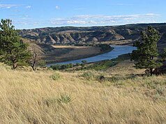
| Missouri River in the National Monument | ||
|
|
||
| Location: | Montana , United States | |
| Specialty: | 240 km river course with almost wilderness character in the prairie landscape | |
| Next city: | Great Falls | |
| Surface: | 1,517.6 km² | |
| Founding: | January 17, 2001 | |
| River bend in the National Monument | ||
Upper Missouri River Breaks National Monument is a national monument- type nature reserve in the US state of Montana . The area extends along the upper reaches of the Missouri River and is called after the break called steep banks of sandstone and clay schist . The underdeveloped reserve was established by President Bill Clinton in his last days in early 2001 and is administered by the Bureau of Land Management , an agency of the US Department of the Interior .
description
The highlands of Montana consist of a gentle hilly landscape, which is covered with a dry short-grass prairie . Geologically, it consists of sediments deposited by rivers from the Rocky Mountains in the form of alluvial fans in a vast inland sea. These were compacted to sandstone, slate and siltstone in later geological ages . In two places in the area there are remains of volcanic chimneys that protrude about 60 m above the surrounding area.
The Missouri River has dug itself into this landscape and exposed the stratification of the rocks on its steep banks. The protected area extends along the river in a west-east direction for around 240 km with an average width of over 5 km.
230 bird and 60 mammal species live in the area, making it one of the most biodiverse in the United States and preserving the original state of the Great Plains .
There are paved roads only at the endpoints of the National Monument, in the west of US Highway 87 , in the east the bridge of US Highway 191 forms the border. Unpaved gravel roads extend into the area in various places and in the summer months two ferries allow crossing the river.
Before it was placed under protection, the monument was the largest undeveloped area in federal ownership in the 48 contiguous states that was not subject to any special dedication. In the east it overlaps slightly with the Charles M. Russel National Wildlife Refuge , the river itself had been designated as a Wild and Scenic River since 1976 .
history
The original inhabitants of the Breaks were the Indian peoples of the Blackfoot , Assiniboin , Gros Ventre , Absarokee (also called Crow), Cree and Anishinabe (also Ojibwa or Chippewa). They, too, had only immigrated to the region in significant numbers with the advent of the horse, which was previously uninhabitable because of the great distances and the low density of food sources. French trappers and fur traders were the first whites to explore the Missouri in the 18th century. The Lewis and Clark Expedition passed through what is now the sanctuary in 1805, and the participants made the first scientific records and descriptions of the area. Here they also discovered the first fork jack that a white man saw.
The large American fur companies Missouri Fur Company , Rocky Mountain Fur Company and especially the American Fur Company used the area intensively in the first third of the 19th century until the beaver populations collapsed in the 1830s . As a result, the region was loosely settled in accordance with the Heimstättengesetz . In the 1840s and 1850s, several major negotiations took place on the Missouri River between representatives of the US government and the Indians. In 1877 the Nez Percé crossed the river in today's protected area on their escape from persecution and were captured by the army about 60 km north of the Missouri just before the Canadian border and had to give up ( see: Campaign against the Nez Percé ).
From 1897 the painter Charles M. Russell lived near Great Falls and created many of his large-format landscape paintings with prairie motifs in today's monument or its immediate vicinity.
Upper Missouri River Breaks Today
In Montana, hunting , fishing , canoeing, and other tourist activities first surpassed agriculture as an industry in 2003. The Upper Missouri River Breaks National Monument is an excellent hunting ground for elk , bighorn sheep , mule deer , white-tailed deer and pronghorn , prairie birds such as mugwort , several species of prairie grouse , partridge and pheasant, and some waterfowl.
Hunting and the existing usage contracts for grazing federally owned land by private farmers will continue to exist even after they have been placed under protection. Due to the size of the area and the currently low intensity of the interventions, the conflicts of use are limited.
A new visitor center has been in operation in Fort Benton on the western edge of the monument since the end of 2006 .


