
Interstate 90
 |
|||||||||||||||||||||||||||||||||||||||||||||||||||||||||||||||||||||||||||||||||||||||||||||||||||||||||||||||||||||||||||||||||||||||||||||||||||||||||||||||||||
| Basic data | |||||||||||||||||||||||||||||||||||||||||||||||||||||||||||||||||||||||||||||||||||||||||||||||||||||||||||||||||||||||||||||||||||||||||||||||||||||||||||||||||||
|---|---|---|---|---|---|---|---|---|---|---|---|---|---|---|---|---|---|---|---|---|---|---|---|---|---|---|---|---|---|---|---|---|---|---|---|---|---|---|---|---|---|---|---|---|---|---|---|---|---|---|---|---|---|---|---|---|---|---|---|---|---|---|---|---|---|---|---|---|---|---|---|---|---|---|---|---|---|---|---|---|---|---|---|---|---|---|---|---|---|---|---|---|---|---|---|---|---|---|---|---|---|---|---|---|---|---|---|---|---|---|---|---|---|---|---|---|---|---|---|---|---|---|---|---|---|---|---|---|---|---|---|---|---|---|---|---|---|---|---|---|---|---|---|---|---|---|---|---|---|---|---|---|---|---|---|---|---|---|---|---|---|---|---|
| Length: | 3099 mi / 4958 km | ||||||||||||||||||||||||||||||||||||||||||||||||||||||||||||||||||||||||||||||||||||||||||||||||||||||||||||||||||||||||||||||||||||||||||||||||||||||||||||||||||
| States: |
Washington Idaho Montana Wyoming South Dakota Minnesota Wisconsin Illinois Indiana Ohio Pennsylvania New York Massachusetts |
||||||||||||||||||||||||||||||||||||||||||||||||||||||||||||||||||||||||||||||||||||||||||||||||||||||||||||||||||||||||||||||||||||||||||||||||||||||||||||||||||
| map | |||||||||||||||||||||||||||||||||||||||||||||||||||||||||||||||||||||||||||||||||||||||||||||||||||||||||||||||||||||||||||||||||||||||||||||||||||||||||||||||||||

|
|||||||||||||||||||||||||||||||||||||||||||||||||||||||||||||||||||||||||||||||||||||||||||||||||||||||||||||||||||||||||||||||||||||||||||||||||||||||||||||||||||
|
course
|
|||||||||||||||||||||||||||||||||||||||||||||||||||||||||||||||||||||||||||||||||||||||||||||||||||||||||||||||||||||||||||||||||||||||||||||||||||||||||||||||||||
The Interstate 90 (abbreviated I-90 ) with a length of approximately 5000 km the longest interstate highway of the United States . It begins in Seattle on the Pacific Ocean and ends in Boston on the Atlantic Ocean , where it is known as the Massachusetts Turnpike east of the state line with New York . The eastern states tend to have a maximum speed of 65 mph (about 105 km / h), while the sprawling western states typically have a speed limit of 75 mph (120 km / h). East of the Wisconsin / Illinois border, I-90 is mostly toll roads .
Length of I-90 in each state
| miles | kilometre | Country | |
| 296.92 | 477.85 | Washington | |
| 73.55 | 118.37 | Idaho | |
| 551.68 | 887.84 | Montana | |
| 208.8 | 336.03 | Wyoming | |
| 412.76 | 664.27 | South Dakota | |
| 275.7 | 443.70 | Minnesota | |
| 187.14 | 301.84 | Wisconsin | |
| 123.89 | 199.38 | Illinois | |
| 156.28 | 251.51 | Indiana | |
| 244.75 | 393.89 | Ohio | |
| 46.4 | 74.67 | Pennsylvania | |
| 385.48 | 620.37 | new York | |
| 135.72 | 218.42 | Massachusetts | |
| 3,099.07 | 4,958.51 | total | |
Feeders and bypasses
- Interstate 190 at Rapid City
- Interstate 190 and Interstate 290 near Chicago
- Interstate 490 at Cleveland
- Interstate 190 , Interstate 290, and Interstate 990 at Buffalo
- Interstate 390 , Interstate 490 and Interstate 590 at Rochester
- Interstate 690 at Syracuse
- Interstate 790 at Utica
- Interstate 890 at Schenectady
- Interstate 290 to Interstate 495 at Marlborough
- Interstate 190 to Leominster
photos

I-90 and I-5 cross in Seattle
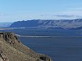
The bridge over Wanapum Lake in Washington state

The Business Loop in Austin, Minnesota

The eastern beginning of I-90 in Boston, Massachusetts


See also
Web links
| Main Interstates |
2 • 4 • 5 • 8 • 10 • 12 • 15 • 16 • 17 • 19 • 20 • 22 • 24 • 25 • 26 • 27 • 29 • 30 • 35 • 37 • 39 • 40 • 43 • 44 • 45 • 49 • 55 • 57 • 59 • 64 • 65 • 66 • 68 • 69 • 70 • 71 • 72 • 73 • 74 • 75 • 76 (west) • 76 (east) • 77 • 78 • 79 • 80 • 81 • 82 • 83 • 84 (West) • 84 (East) • 85 • 86 (West) • 86 (East) • 87 • 88 (West) • 88 (East) • 89 • 90 • 91 • 93 • 94 • 95 • 96 • 97 • 99 |

|
|---|---|---|
| Hawaii | ||
| Alaska | ||
| Puerto Rico |