Interstate 68
| Basic data | |
|---|---|
| Length: | 112.9 mi / 181.7 km |
| States: |
West Virginia Maryland |
| map | |

|
|
|
course
|
|
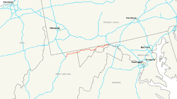
The Interstate 68 (abbreviated I-68 ) is an interstate highway in the United States . It connects Interstate 79 near Morgantown in West Virginia with Interstate 70 and US Highway 522 near Hancock in Maryland .
Lengths
| State | miles | kilometre |
| West Virginia | 31.5 | 50.7 |
| Maryland | 81.1 | 130.5 |
| overall length | 112.6 | 181.2 |
history
Originally, the designation Interstate 68 was intended for the freeway on US Highways 50 and 301 between Washington DC and Annapolis , which is now designated as Interstate 595 . On June 7, 1989, the American Association of State Highway and Transportation Officials approved the designation Interstate 68 for the route between Morgantown and Hancock.
course
West Virginia
Interstate 68 branches off south of the Monongahela River from Interstate 79 in a northeasterly direction and crosses US Highway 119 after 1.6 kilometers . The interstate first passes the city of Morgantown in the northwest and then the Morgantown Municipal Airport . To the west of the village of Cheat Lake , the road crosses the lake of the same name and rises at the northern foothills of the Cheat Canyon . I-68 runs south along Coopers Rock State Forest . To the south of the city of Bruceton Mills , the road first crosses Big Sandy Creek and then meets West Virginia State Route 26 . East of Bruceton Mills it runs through rural and mountainous areas. The interstate passes Brandonville in the north and Hazelton in the south before reaching the Maryland border.
Maryland
In Maryland, Interstate 68 continues to run through mountainous terrain and is called the National Freeway for the entire route . Friendsville is the first city to be passed by I-68 in Maryland. In the west of the city, the road first meets Maryland State Route 42 and then crosses the Youghiogheny River . From the town of Keysers Ridge , US Highways 40 and 129 run together with the interstate on the same route. North of the Savage River State Forest , the US 129 is already leaving the route again. With the crossing of Savage Mountain , Interstate 68 reaches Allegany County . It forms a southern bypass around the city of Frostburg and meets Maryland State Routes 736 and 36 .
East of Frostbrug, the road follows the valley of Braddock Run and intersects Maryland State Route 658 . After crossing Haystack Mountain , the interstate enters the urban area of Cumberland . The I-68 runs a common route with the US Highways 40 and 220 through the city and crosses the Wills Creek in the center shortly before its confluence with the Potomac River . Interstate 68 leaves the city in a northerly direction and passes Rocky Gap State Park with Lake Habeeb in the north . East of Flintstone , the road crosses Town Creek and Polish Mountain and runs through the Green Ridge State Forest .
With the crossing of Sideling Hill Creek , Interstate 68 reaches Washington County and then crosses the Sideling Hills . It ends after a total of 181 kilometers at the route of Interstate 70 and US Highway 522 in the north of Hancock.
swell
- ↑ Interstate Guide: Interstate 68 , accessed August 2, 2010
Web links
- Roads to the Future: National Freeway (I-68 )
- MDRoads: I-68 (English)


