Youghiogheny River
| Youghiogheny River | ||
|
Ohiopyle Falls of the Youghiogheny River |
||
| Data | ||
| Water code | US : 595217 | |
| location | Pennsylvania , Maryland , West Virginia (USA) | |
| River system | Mississippi River | |
| Drain over | Monongahela River → Ohio River → Mississippi River → Gulf of Mexico | |
| source | in Preston County, West Virginia, 39 ° 14 ′ 43 " N , 79 ° 29 ′ 19" W |
|
| Source height | 762.5 m | |
| muzzle | in the Monongahela River at McKeesport Coordinates: 40 ° 21 '15 " N , 79 ° 52' 13" W 40 ° 21 '15 " N , 79 ° 52' 13" W |
|
| Mouth height | 221 m | |
| Height difference | 541.5 m | |
| Bottom slope | 2.8 ‰ | |
| length | 196 km | |
| Catchment area | 4440 km² | |
| Drain |
MQ |
99 m³ / s |
| Right tributaries | Casselman River | |
| Reservoirs flowed through | Youghiogheny River Lake | |
| Small towns | McKeesport , Connellsville | |
|
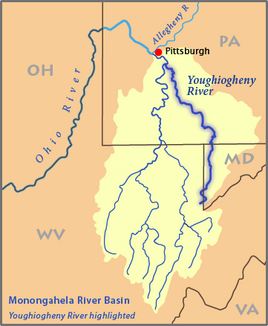
Map of the catchment area of the Monongahela River, the river is highlighted. |
||
|
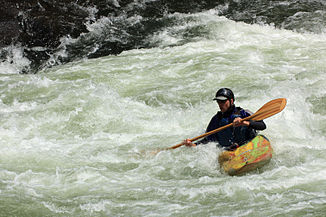
Parts of the river are used intensively for white water sports |
||
The Youghiogheny River (pronunciation: [ˌjɑ.kəˈgeɪ.ni] ) is a 196 km long right tributary of the Monongahela River in the US states of West Virginia , Maryland and Pennsylvania .
It drains the west side of the Allegheny Mountains and serves as a receiving water from rivulets and streams in the extreme west of Maryland to the catchment area of the Mississippi River , to which it belongs via the Monongahela River and the Ohio River . The area of its catchment area is 4440 km².
geography
The Youghiogheny River rises in northern West Virginia in Preston County , southeast of the county seat Kingwood and near the Backbone Mountain . The headwaters of the river are only 10 miles from the headwaters of the North Branch of the Potomac River . The river first flows in a north-northeast direction into Garrett County , Maryland, where it runs parallel to the state line with West Virginia for about 3 miles. On this section it flows past Oakland .
Between Fayette and Somerset Counties , it crosses the state line into Pennsylvania. He continued on his way to the northeast through a breakthrough at Chestnut Ridge and then passed Connellsville . Coming from the southeast it flows into McKeesport , southeast of Pittsburgh into the Monongahela River .
Upriver from Confluence , about 6 miles north of the Maryland-Pennsylvania border, is Youghiogheny River Lake . It is dammed in Pennsylvania by the 56 m high Youghiogheny Dam . The lake was built in 1944 mainly for flood control.
Fallingwater, designed by Frank Lloyd Wright , is located in the valley of the river southeast of Connellsville.
history
During the colonial days and in the early days of the United States, the river valley was an important access route for settlers and soldiers across the mountains from Virginia to the Ohio area of western Pennsylvania. In 1754, a militia officer from the British colony of Virginia named George Washington followed the river to explore a waterway to Fort Duquesne, then French-owned .
A former fort near Somerset was flooded after Youghiogheny Dam was built. Perryopolis in northern Fayette County is where the George Washington Grist Mill is located. The Youghiogheny River Trail follows the river in southwest Pennsylvania, southeast of Connellsville.
Flow rate
The United States Geological Survey operates a gauge in Sutersville and the average annual runoff of the river there is 99 m³ / s. Since Sutersville is a few miles above the estuary, the actual amount of water the river brings into the Monongahela River is slightly higher.
Web links
Individual evidence
- ↑ Youghiogheny River in the Geographic Names Information System of the United States Geological Survey
- ↑ Youghiogheny River in the Geographic Names Information System of the United States Geological Survey
- ↑ United States Geological Survey (USGS); USGS 03083500 Youghiogheny River at Sutersville, PA . Retrieved October 1, 2007.
- ↑ USGS, Table of average annual daily discharges for Youghiogheny River at Sutersville, PA , accessed October 1, 2007.


