Ohio River
|
Ohio River Oyo |
||
|
Course of the river and drainage basin of the Ohio River |
||
| Data | ||
| Water code | US : 425264 | |
| location | Pennsylvania , Ohio , West Virginia , Kentucky , Indiana , Illinois (USA) | |
| River system | Mississippi | |
| Drain over | Mississippi → Gulf of Mexico | |
| Confluence of |
Allegheny River and Monongahela River in Pittsburgh, PA 40 ° 26 ′ 30 ″ N , 80 ° 0 ′ 58 ″ W |
|
| Source height | 222 m | |
| muzzle | in the Mississippi near Cairo, IL Coordinates: 36 ° 59 ′ 12 " N , 89 ° 7 ′ 52" W 36 ° 59 ′ 12 " N , 89 ° 7 ′ 52" W |
|
| Mouth height | 88 m | |
| Height difference | 134 m | |
| Bottom slope | 0.08 ‰ | |
| length | 1579 km (with Allegheny: 2102 km) | |
| Catchment area | 490,574 km² | |
| Drain |
MQ 1951/1980 |
7973 m³ / s |
| Left tributaries | Sandy Creek , Guyandotte River , Kanawha River , Kentucky River , Cumberland River , Tennessee River | |
| Right tributaries | Muskingum River , Scioto River , Wabash River | |
| Big cities | Pittsburgh, PA , Cincinnati, OH , Louisville, KY , Evansville, IN | |
| Navigable | along the whole length | |
|
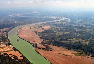
The river on the Indiana and Illinois border |
||
|
Ohio, Monongahela and Allegheny (here still called Ohio ) between Appalachians and Lake Erie on a map by George Washington (diary supplement, ed. 1754) |
||
|
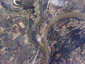
Mouth of the recognizable larger Ohio (right) near Cairo, IL ; Satellite image |
||
|
Push convoy on the Ohio (Parkersburg), West Virginia |
||
|
Lawrenceburg, Indiana is one of the many port cities on the Ohio |
||
|
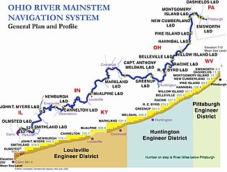
Locks and dams on the Ohio River |
||
The Ohio (Indian language Oyo , English Ohio River ) is the largest left tributary of the Mississippi . It is created by the union of the two rivers Allegheny (main source river) and Monongahela in Pittsburgh . Near the city of Cairo , the Ohio flows into the so-called Upper Mississippi (Upper Mississippi) . The Ohio is navigable along its entire length of 1,579 km.
The Ohio drains most of the eastern United States . The catchment area includes 14 states, including most of the southern states on the east coast . At its mouth, the Ohio carries around a third more water than the Mississippi, making it the main hydrological river in the Mississippi river system .
Origin of name
The name Ohio comes from the Iroquois and means "good river".
In the past, the Allegheny, as the actual upper course of the river, also bore the name Ohio , for example among the Seneca-Iroquois . However, the name Ohio only applies from the confluence of the Allegheny and Monongahela in Point State Park in Pittsburgh. The name only refers to the lower three quarters of the entire course of the river (length with Allegheny: 2102 km).
Geography and hydrography
From Pittsburgh the Ohio first flows northwest through the counties Allegheny and Beaver , before it makes an abrupt turn to the south-southwest in the triangle of the border lines of the three states of West Virginia , Ohio and Pennsylvania between East Liverpool , Chester and Midland . The river then follows approximately a southwesterly direction to Huntington, West Virginia . It then swings west-northwest before heading west-southwest at Cincinnati for the remainder of its run.
The river successively forms the border between West Virginia and Ohio, Ohio and Kentucky , Indiana and Kentucky, and Illinois and Kentucky.
Shortly before the Ohio flows into the Mississippi at Cairo, it reaches its largest tributary from the left, the Tennessee River .
At the mouth near the city of Cairo, the water flow of the Ohio with 7973 m³ / s clearly exceeds that of the Mississippi, which at this point is 5865 m³ / s.
The Ohio is located in the transition area between the humid subtropical climate zone and a humid continental climate of the temperate zone , which is why flora and fauna elements from both climate zones can be found on its banks .
Tributaries
The main tributaries include:
- Allegheny River - Pittsburgh, PA (main spring river)
- Monongahela River - Pittsburgh, PA (second headwaters)
- Chartiers Creek - Pittsburgh, PA
- Beaver River - Rochester, PA
- Wheeling Creek —– Wheeling, WV
- Little Muskingum River - Ohio
- Duck Creek - Ohio
- Muskingum River - Marietta , Ohio
- Little Kanawha River - Parkersburg, WV
- Hocking River - Ohio
- Kanawha River - Point Pleasant , WV
- Guyandotte River - Huntington, WV
- Big Sandy River - on the border of Kentucky and West Virginia
- Scioto River - Portsmouth, OH
- Little Miami River - Cincinnati
- Licking River - Newport-Covinton
- Great Miami River - on the Ohio-Indiana border
- Salt River - West Point, KY
- Kentucky River - Carrollton, KY
- Green River - Kentucky
- Wabash River - on the Indiana and Illinois border
- Saline River - Illinois
- Cumberland River - Kentucky
- Tennessee River - Paducah, KY (largest tributary)
- Cache River - Illinois
Catchment area
The Ohio catchment area covers 490,603 km² and covers substantial parts of the eastern Mississippi catchment area . The following states partially drain in the Ohio (with details of the areas draining into the Ohio):
- Illinois - Southeastern District
- Indiana - middle and southern area
- Ohio - southern half
- New York - a small area in the south on the Allegheny River
- Pennsylvania - a strip from the southwest corner to the center of the northern border
- Maryland - a small strip along the Youghiogheny River to the west
- West Virginia - with the exception of the Eastern Panhandle of West Virginia
- Kentucky - with the exception of a small area in the far west that drains directly into the Mississippi
- Tennessee - with the exception of an area in the far west that drains directly into the Mississippi and a small area in the southeast corner
- Virginia - most of the southwest
- North Carolina - western quarter
- Georgia - northwest corner
- Alabama - northern area
- Mississippi - Northeast Corner
history
During the colonization of North America, the river served as a transport route to the west and therefore had a great influence on the history of the North American Indians .
The Ohio was the southern border of the Northwest Territory during the 19th century and therefore formed the northern border of slavery in the United States until the Civil War . It is considered to be the western extension of the Mason-Dixon Line and the sometimes controversial border between the northern and southern states (see also Upland South ). The river was therefore of great strategic importance during the Civil War. Its security by Union forces in the first phase of the war laid an important foundation for the victory over the Confederates.
In January and February 1937, a flood disaster occurred with record-breaking damage. Floods from Pittsburgh to the estuary left a million people homeless and 385 people were killed. The public budgets of the affected countries were significantly burdened by the aid measures, especially since the global economic crisis was not yet completely over (see New Deal ).
Use and shipping
The Ohio was originally a relatively shallow river. However, it was deepened in the course of numerous hydraulic engineering measures from the end of the 19th century and dammed by means of several dams , so that commercial inland shipping is possible throughout. Buildings such as Merrill Lock No. 6 .
Water depth
Below the confluence of the Allegheny Rivers and Monongahela Rivers in Pittsburgh, the water depth does not initially exceed 9 m at any point, and the average depth is about 8 m. Below Cincinnati, the water depth increases significantly. Due to dams and the glacial deformation of the valley in the final phase of the Nebraska Ice Age , the water depth over a section of 160 km increases almost five times. West of Louisville, Kentucky, is the deepest point at 51 m. The average water depth in an area 50 miles around Louisville is 40 yards, and the river is home to much larger ships in this area. The depth then steadily decreases again up to the confluence with the Mississippi, as the river valley is no longer so narrow and the river reaches a width of up to 1.6 km. Shortly before the mouth, the depth is only about 6 m.
The water levels for the river are reported daily by the National Oceanic and Atmospheric Administration (NOAA). The predictions for the possible diving depths are based on precipitation-runoff models.
Designations
The County Ohio County , Indiana, Ohio County in Kentucky and Ohio County in West Virginia are named after the Ohio River.
See also
Web links
Individual evidence
- ↑ a b c Frits van der Leeden, Fred L. Troise, David Keith Todd: The Water Encyclopedia . 2nd Edition. Lewis Publishers, Chelsea, Mich. 1990, ISBN 0-87371-120-3 , pp. 126 .
- ^ Online Etymology Dictionary under Ohio
- ^ Level Thebes, Global Runoff Data Center (2008): Long-Term Mean Monthly Discharges and Annual Characteristics of GRDC Station / Global Runoff Data Center. Federal Institute for Hydrology (BfG), Koblenz 2009.
- ^ Joseph H. Bausman: History of Beaver County Pennsylvania and Its Centennial Celebration . Knickerbocker, New York City 1904, p. 248-250 ( books.google.com ).
-
↑ NOAA website for the Ohio River ( Memento of the original from May 13, 2007 in the Internet Archive ) Info: The archive link was automatically inserted and has not yet been checked. Please check the original and archive link according to the instructions and then remove this notice. . The publication is made separately for the following five river sections
- Pittsburgh, Pennsylvania to Hannibal Dam, Ohio, including the Allegheny River and Monongahela River ( Memento of the original from January 27, 2008 in the Internet Archive )
- Willow Island Dam, Ohio to Greenup Dam, Kentucky ( Memento of the original from February 2, 2008 in the Internet Archive ) Info: The archive link was automatically inserted and has not yet been checked. Please check the original and archive link according to the instructions and then remove this notice.
- Portsmouth, Ohio to Markland Dam, Kentucky ( Memento of the original from February 10, 2008 in the Internet Archive ) Info: The archive link was automatically inserted and not yet checked. Please check the original and archive link according to the instructions and then remove this notice.
- McAlpine Dam, Kentucky to Cannelton Dam, Indiana ( Memento of the original from January 5, 2008 in the Internet Archive ) Info: The archive link was inserted automatically and has not yet been checked. Please check the original and archive link according to the instructions and then remove this notice.
- Newburgh Dam, Indiana to Golconda, Illinois ( Memento of the original from February 12, 2008 in the Internet Archive ) Info: The archive link was automatically inserted and not yet checked. Please check the original and archive link according to the instructions and then remove this notice.


