Scioto River
| Scioto River | ||
|
Scioto River in Columbus |
||
| Data | ||
| Water code | US : 1072258 | |
| location | Ohio (USA) | |
| River system | Mississippi River | |
| Drain over | Ohio River → Mississippi River → Gulf of Mexico | |
| origin | at New Hampshire, Ohio 40 ° 36 '32 " N , 83 ° 52' 37" W. |
|
| Source height | 203 m | |
| muzzle | Ohio River near Portsmouth Coordinates: 38 ° 43 '50 " N , 83 ° 0' 46" W 38 ° 43 '50 " N , 83 ° 0' 46" W. |
|
| Mouth height | 148 m | |
| Height difference | 55 m | |
| Bottom slope | 0.15 ‰ | |
| length | 372 km | |
| Catchment area | 10,486 km² | |
| Left tributaries | Olentangy River , Big Walnut Creek | |
| Right tributaries | Paint Creek | |
| Big cities | Columbus | |
|
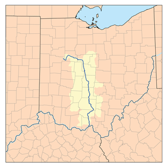
Scioto River catchment area |
||
The Scioto River is a right tributary of the Ohio River in the central and southern US state of Ohio of about 372 km in length.
The name comes from an Indian word for "deer". It rises in Auglaize County near New Hampshire, first flows 80 km in an easterly direction and then turns south to flow into the Ohio River near the city of Portsmouth. At Columbus it takes its largest tributary, the Olentangy River coming from the north . The Scioto River, which used to be a popular transport route north, is now primarily used as a recreation area and drinking water reservoir.
The Scioto River valley was home to numerous Indian cultures. The best known is the Hopewell culture , to which the so-called mounds bear witness. They can be viewed at Chillicothe in the Hopewell Culture National Historic Park . In the 17th and 18th centuries the Shawnee , Delaware , Miami , Odawa and Mingo lived here for a time . Their main villages on the Scioto River were Chillicothe, Piqua, Kispoko and Maqueechalk. During the Northwest Indian War (1785–1795), the valley was the scene of numerous skirmishes between the tribes living there and the American army.
At the beginning of the 19th century, the so-called Underground Railroad led along the Scioto River to freedom for runaway slaves from the south , after they had crossed the Ohio River. Many of them found their first refuge in Chillicothe and neighboring towns.
Individual evidence
- ↑ a b Google Earth altitude for GNIS coordinates, accessed on July 23, 2010.
- ↑ Scioto River in the Geographic Names Information System of the United States Geological Survey
- ↑ a b c Scioto River. Retrieved July 23, 2010 .
- ↑ Bruce G. Trigger (Ed.): Handbook of North American Indians . Vol. 15: Northeast. Smithsonian Institution Press, Washington DC 1978, pp. 623 ISBN 0-16004-575-4

