Paint Creek (Scioto River)
| Paint Creek, Ohio | ||
|
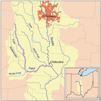
The Paint Creek within the Scioto River Basin. |
||
| Data | ||
| Water code | US : 1066883 | |
| location | south of central Ohio , USA | |
| River system | Mississippi River | |
| Drain over | Scioto River → Ohio River → Mississippi River → Gulf of Mexico | |
| origin | 7 km west of London in southwest Madison County, OH 39 ° 52 ′ 17 ″ N , 83 ° 33 ′ 16 ″ W |
|
| Source height | 347 m | |
| muzzle | Scioto River, 4 miles southeast of Chillicothe in central Ross County. OH coordinates: 39 ° 17 ′ 43 " N , 82 ° 56 ′ 0" W 39 ° 17 ′ 43 " N , 82 ° 56 ′ 0" W |
|
| Mouth height | 179 m | |
| Height difference | 168 m | |
| Bottom slope | 1.1 ‰ | |
| length | 152.5 km | |
| Catchment area | 2963 km² | |
| Left tributaries | North Fork Paint Creek | |
| Right tributaries | Rattlesnake Creek, Sugar Creek, Rocky Fork Paint Creek, East Fork Paint Creek | |
| Reservoirs flowed through | Paint Creek Lake | |
The Paint Creek is a 152.5 km long right tributary of the Scioto River in the south-central US state Ohio . It drains a catchment area of 2,960 square kilometers and is part of the river system of the Mississippi River . The outflow is via the Scioto River, Ohio River and Mississippi River into the Gulf of Mexico .
The Paint Creek rises in southwest Madison County , about 7 kilometers west of the city of London . It flows first south-southwest through Fayette County and then south on the border of Counties Highland and Ross . South of the town of Greenfield , Paint Creek is dammed by a dam and forms Paint Creek Lake , which is located in Paint Creek State Park . As it exits the lake, the river bends east, flows through Ross County and flows into the Scioto River 4 km southeast of Chillicothe .
The main tributaries are the 75 km long North Fork Paint Creek and 68 km long Rattlesnake Creek . According to the Geographic Names Information System , the river has also been called Alamoneetheepeece, Olomon Sepung, Chilicotha Creek, Pain Creek, and Pait Creek throughout its history .
Individual evidence
- ↑ a b Google Earth altitude for GNIS coordinates, accessed on August 26, 2010.
- ↑ a b c Gazetteer of Ohio Streams ( Memento from October 20, 2013 in the Internet Archive ) (PDF; 1.8 MB), accessed on August 26, 2010.
- ^ Paint Creek (Scioto River) in the Geographic Names Information System of the United States Geological Survey North Fork
- ↑ Paint Creek (Scioto River) in the Geographic Names Information System of the United States Geological Survey Rattlesnake Creek
- ↑ Paint Creek (Scioto River) in the Geographic Names Information System of the United States Geological Survey
Web links
- Paint Creek (Scioto River) in the Geographic Names Information System of the United States Geological Survey
- Paint Creek (Scioto River) in the Geographic Names Information System of the United States Geological Survey , Paint Creek Lake
- Paint Creek State Park
- Gazetteer of Ohio Streams ( Memento from October 20, 2013 in the Internet Archive ) (PDF; 1.8 MB)
- Paint Creek Watershed ( August 8, 2007 memento in the Internet Archive )

