Kanawha River
| Kanawha River | ||
|
Kanawha River at Saint Albans |
||
| Data | ||
| Water code | US : 1551620 | |
| location | West Virginia (USA) | |
| River system | Mississippi River | |
| Drain over | Ohio River → Mississippi River → Gulf of Mexico | |
| Confluence of |
New River and Gauley River at Gauley Bridge 38 ° 9 ′ 41 ″ N , 81 ° 11 ′ 47 ″ W |
|
| Source height | 199 m | |
| muzzle | in the Ohio River at Point Pleasant Coordinates: 38 ° 50 ′ 14 " N , 82 ° 8 ′ 31" W 38 ° 50 ′ 14 " N , 82 ° 8 ′ 31" W |
|
| Mouth height | 165 m | |
| Height difference | 34 m | |
| Bottom slope | 0.22 ‰ | |
| length | 156 km | |
| Catchment area | 31,690 km² | |
| Drain |
MQ |
537 m³ / s |
| Left tributaries | Coal River | |
| Right tributaries | Elk River , Pocatalico River | |
| Medium-sized cities | Charleston | |
| Small towns | Saint Albans , Point Pleasant | |
| Navigable | to deep water | |
|
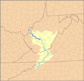
Map of the catchment area of the river with its main source river, the New River |
||
|
Lock and weir in Winfield, WV, 50 km above the estuary |
||
|
The Kanawha River meets the Ohio River at Point Pleasant, WV |
||
|
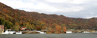
Kanawha Falls on the Kanawha River near Gauley Bridge |
||
The Kanawha River is a 156 km long, left tributary of the Ohio River in West Virginia .
As the largest waterway within the state , the river formed an important economic region from the middle of the 19th century.
The river arises at the town of Gauley Bridge in the northwest of Fayette County , about 55 km southeast of Charleston by the confluence of the New River and Gauley River . He always flows in a northwesterly direction in a winding course through the non- glacial embossed Allegheny Plateau by the counties Fayette, Kanawha , Putnam and Mason . He passes the cities of Charleston and Saint Albans , as well as a number of smaller towns. It flows into the Ohio River at Point Pleasant .
The river valley has significant deposits of coal and natural gas . At the time of colonization, the river's fluctuating water level prevented it from being used as a traffic route. The removal of rocks and tree stumps on the lower reaches during the 1840s made shipping possible, which was expanded after the construction of locks and weirs in 1875. Today the river is navigable to Deep Water , a town about 35 km upstream from Charleston.
Below Charleston, on the banks of the river, is the largest concentration of the chemical industry in the United States, which is why the Kanawha Valley is also known as the Chemical Valley . DuPont , Monsanto and Union Carbide built large plants as early as the 1960s , the latter now owned by Bayer CropScience after several mergers . The plants contribute significantly to West Virginia's economy.
Tributaries
Apart from the New River and Gauley River, the Elk River flows into the Kanawha River at Charleston , the Coal River at Saint Albans and the Pocatalico River at Poca .
Cities along the Kanawha River
Variants of the name
The Geographic Names Information System gives a number of alternative names for the Kanawha River:
|
|
|
Highways
- The Interstate 64 crosses the Kanawha River four times around Charleston.
literature
- Arthur Benke & Colbert Cushing, Rivers of North America . Elsevier Academic Press. 2005. ISBN 0-12-088253-1
- Rhodes, Captain Rick, The Ohio River in American History and Voyaging on Today's River . Heron Island Guides. 2007. ISBN 978-0-9665866-3-3


