Beaver County, Pennsylvania
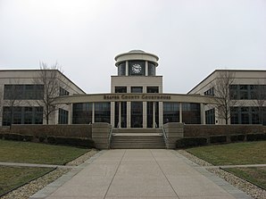
 Beaver County Courthouse |
|
| administration | |
|---|---|
| US state : | Pennsylvania |
| Administrative headquarters : | Beaver |
| Address of the administrative headquarters: |
Courthouse 821 Third Street Beaver, PA 15009 |
| Foundation : | March 12, 1800 |
| Made up from: |
Allegheny County Washington County |
| Area code : | 001 724 |
| Demographics | |
| Residents : | 170,539 (2010 estimate) |
| Population density : | 151.6 inhabitants / km 2 |
| geography | |
| Total area : | 1150 km² |
| Water surface : | 25 km² |
| map | |
| Website : www.beavercountypa.gov | |
The Beaver County is a county in the US state of Pennsylvania . At the 2010 census , the county had 170,539 people and a population density of 151.6 people per square kilometer. The county seat is Beaver . "Beaver" is the English name for the beaver .
Beaver County is part of the metropolitan area around the city of Pittsburgh .
geography
The county is located in the southwest of Pennsylvania and is traversed by the Beaver River in a southerly direction before it flows into the Ohio River in the center of the county .
Beaver County, which borders the states of West Virginia and Ohio to the west, has an area of 1,150 square kilometers, of which 25 square kilometers are water.
The following counties border Beaver County:
|
Columbiana County (Ohio) |
Lawrence County | |

|
Butler County | |
|
Hancock County, West Virginia |
Washington County | Allegheny County |
history
The county was formed on March 12, 1800 from former parts of Allegheny and Washington Counties. It was named after the Beaver River .
Three locations in the county have National Historic Landmark status , the Old Economy Museum Village , Matthew S. Quay House, and the Beginning Point of the US Public Land Survey . 19 buildings and sites in the county are listed on the National Register of Historic Places (NRHP) (as of July 20, 2018).
Demographic data
| Population development | |||
|---|---|---|---|
| Census | Residents | ± in% | |
| 1800 | 5776 | - | |
| 1810 | 12,168 | 110.7% | |
| 1820 | 15,340 | 26.1% | |
| 1830 | 24,183 | 57.6% | |
| 1840 | 29,368 | 21.4% | |
| 1850 | 26,689 | -9.1% | |
| 1860 | 29,140 | 9.2% | |
| 1870 | 36,148 | 24% | |
| 1880 | 39,605 | 9.6% | |
| 1890 | 50,077 | 26.4% | |
| 1900 | 56,432 | 12.7% | |
| 1910 | 78,253 | 38.7% | |
| 1920 | 111,621 | 42.6% | |
| 1930 | 149.062 | 33.5% | |
| 1940 | 156.754 | 5.2% | |
| 1950 | 175.192 | 11.8% | |
| 1960 | 206,948 | 18.1% | |
| 1970 | 208,418 | 0.7% | |
| 1980 | 204,441 | -1.9% | |
| 1990 | 186.093 | -9% | |
| 2000 | 181.412 | -2.5% | |
| 2010 | 170,539 | -6% | |
| before 1900 1900–1990 2000 2010 | |||
According to the 2010 census , Beaver County had 170,539 people in 71,632 households. The population density was 151.6 inhabitants per square kilometer.
The racial the population was composed of 91.2 percent white, 6.3 percent African American, 0.1 percent Native American, 0.4 percent Asian and other ethnic groups; 1.7 percent were descended from two or more races. Hispanic or Latino of any race was 1.2 percent of the population.
Statistically, 2.36 people lived in the 71,632 households.
20.5 percent of the population were under 18 years old, 60.9 percent were between 18 and 64 and 18.6 percent were 65 years or older. 51.8 percent of the population was female.
The median income for a household was 44,557 USD . The per capita income was $ 23,681. 11.5 percent of the population lived below the poverty line.
Communities
Cities (city)
Boroughs
- Ambridge
- to bathe
- Beaver
- Big Beaver
- Bridgewater
- Conway
- Darlington
- East Rochester
- Eastvale
- Economy
- Ellwood City
- Fall tone
- Frankfort Springs
- Freedom
- Georgetown
- Glasgow
- Homewood
- Hookstown
- Industry
- Paddock
- Midland
- Monaca
- New Brighton
- New Galilee
- Ohioville
- Patterson Heights
- Rochester
- Shippingport
- South Heights
- West Mayfield
Townships
- Brighton Township
- Center township
- Chippewa Township
- Darlington Township
- Daugherty Township
- Franklin Township
- Greene Township
- Hanover Township
- Harmony Township *
- Hopewell Township
- Independence Township
- Marion Township
- New Sewickley Township
- North Sewickley Township
- Patterson Township *
- Potter Township
- Pulaski Township
- Raccoon Township
- Rochester Township
- South Beaver Township
- Vanport Township
- White Township
Individual evidence
- ↑ Beaver County in the United States Geological Survey's Geographic Names Information System.Retrieved February 22, 2011
- ^ National Association of Counties.Retrieved October 29, 2011
- ↑ Charles Curry Aiken, Joseph Nathan Kane: The American Counties: Origins of County Names, Dates of Creation, Area, and Population Data, 1950-2010 . 6th edition. Scarecrow Press, Lanham 2013, ISBN 978-0-8108-8762-6 , p. 19 .
- ↑ Listing of National Historic Landmarks by State: Pennsylvania . National Park Service , accessed July 20, 2018.
- ↑ Search mask database in the National Register Information System. National Park Service , accessed July 20, 2018.
- ^ University of Virginia Library - Historical Census Browser. Retrieved October 29, 2011
- ^ Extract from Census.gov.Retrieved February 28, 2011
- ↑ Excerpt from factfinder.census.gov.Retrieved February 28, 2011
- ↑ United States Census 2010.Retrieved October 29, 2011
- ^ US Census Bureau, State & County QuickFacts - Beaver County. Retrieved October 29, 2011
Web links
- Official website
- US Census Bureau, State & County QuickFacts - Beaver County
- Yahoo Image Search - Beaver County
- www.city-data.com - Beaver County
Coordinates: 40 ° 41 ′ N , 80 ° 21 ′ W


