Blair County
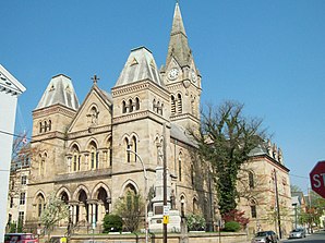
 Blair County Courthouse |
|
| administration | |
|---|---|
| US state : | Pennsylvania |
| Administrative headquarters : | Hollidaysburg |
| Address of the administrative headquarters: |
Blair County Courthouse 423 Allegheny Street Hollidaysburg, PA 16648-2022 |
| Foundation : | February 26, 1846 |
| Made up from: |
Huntingdon County Bedford County |
| Area code : | 001 814 |
| Demographics | |
| Residents : | 129,144 (2000) |
| Population density : | 94.8 inhabitants / km 2 |
| geography | |
| Total area : | 1365 km² |
| Water surface : | 3 km² |
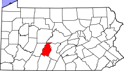
| map | |
| Website : www.blairco.org | |
Blair County is a county in the state of Pennsylvania in the United States . At the 2000 census , the county had 129,144 residents and a population density of 95 people per square kilometer. The county seat is Hollidaysburg .
history
The county was formed from Huntingdon and Bedford Counties on February 26, 1846 and named after John Blair, a member of the Pennsylvania General Assembly who campaigned for the construction of canals and railways.
There is a National Historic Site in the county , the Allegheny Portage Railroad National Historic Site . Two locations have National Historic Landmark status , the Horseshoe Curve and the Leap the Dips roller coaster . 30 buildings and sites in the county are listed on the National Register of Historic Places (NRHP) (as of July 18, 2018).
On December 21, 2012, 4 people were killed and three police officers were injured in a rampage outside the Juniata Valley Gospel Church on Juniata Valley Road in Geeseytown.
geography
The county covers an area of 1,365 square kilometers, of which 3 square kilometers are water. Beaver County is bordered by Center County to the north, Huntingdon County to the east, Bedford County to the south, and Cambria County to the west .
Cities and towns
Blair County is divided into 25 parishes, including a city , 9 boroughs and 15 townships . Tunnelhill borough is only a small part of Blair County. The US Census Bureau maintains two census-designated places for statistical purposes . These are part of a township and have no self-administration.
| Population development | |||
|---|---|---|---|
| Census | Residents | ± in% | |
| 1910 | 108,858 | - | |
| 1920 | 128,334 | 17.9% | |
| 1930 | 139,840 | 9% | |
| 1940 | 140.358 | 0.4% | |
| 1950 | 139,519 | -0.6% | |
| 1960 | 137.270 | -1.6% | |
| 1970 | 135,356 | -1.4% | |
| 1980 | 136,621 | 0.9% | |
| 1990 | 130,542 | -4.4% | |
| 2000 | 129,144 | -1.1% | |
| 1900-1990
2000 |
|||
City
Boroughs
1 partially in Cambria County
Townships
Census-designated places
Attractions
Individual evidence
- ^ Blair County in the Geographic Names Information System of the United States Geological Survey . Retrieved February 22, 2011
- ↑ Charles Curry Aiken, Joseph Nathan Kane: The American Counties: Origins of County Names, Dates of Creation, Area, and Population Data, 1950-2010 . 6th edition. Scarecrow Press, Lanham 2013, ISBN 978-0-8108-8762-6 , p. 25 .
- ↑ Listing of National Historic Landmarks by State: Pennsylvania . National Park Service , accessed July 18, 2018.
- ↑ Search mask database in the National Register Information System. National Park Service , accessed July 18, 2018.
- ^ Altoona Mirror . DA: 4 dead, 3 troopers hurt in shootings [map], 1: 65,000. Retrieved December 21, 2012.
- ↑ Extract from Census.gov . Retrieved February 28, 2011
- ↑ https://factfinder.census.gov/faces/nav/jsf/pages/community_facts.xhtml?src=bkmk# Accessed February 28, 2011
Web links
Coordinates: 40 ° 28 ′ N , 78 ° 21 ′ W

