Juniata County
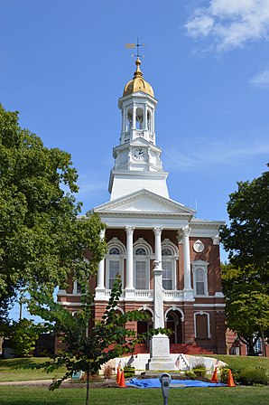
 Juniata County Courthouse |
|
| administration | |
|---|---|
| US state : | Pennsylvania |
| Administrative headquarters : | Mifflintown |
| Address of the administrative headquarters: |
Courthouse P.O.Box 68 Mifflintown, PA 17059 |
| Foundation : | March 2, 1831 |
| Made up from: | Mifflin County |
| Area code : | 001 717 |
| Demographics | |
| Residents : | 23,168 (2007) |
| Population density : | 22.8 inhabitants / km 2 |
| geography | |
| Total area : | 1019 km² |
| Water surface : | 5 km² |
| map | |
| Website : www.co.juniata.pa.us | |
Juniata County is a county in the state of Pennsylvania in the United States . In 2007, the county had an official estimate of 23,168 people and a population density of 22.8 people per square kilometer. The county seat is Mifflintown .
history

The Tuscarora Academy is one of the county's seven entries in the NRHP.
The county was formed on March 2, 1831 and named after the Juniata River .
Seven buildings and sites in the county are listed on the National Register of Historic Places (NRHP) (as of July 23, 2018).
geography
The county covers an area of 1,019 square kilometers, of which 5 square kilometers are water.
Population development
| Population development | |||
|---|---|---|---|
| Census | Residents | ± in% | |
| 1900 | 16,054 | - | |
| 1910 | 15,013 | -6.5% | |
| 1920 | 14,464 | -3.7% | |
| 1930 | 14,325 | -1 % | |
| 1940 | 15,373 | 7.3% | |
| 1950 | 15,243 | -0.8% | |
| 1960 | 15,874 | 4.1% | |
| 1970 | 16,712 | 5.3% | |
| 1980 | 19,188 | 14.8% | |
| 1990 | 20,625 | 7.5% | |
| 2000 | 22,821 | 10.6% | |
| 1900-1990
2000 |
|||
Cities and towns
Web links
Commons : Juniata County - Collection of Pictures, Videos, and Audio Files
Individual evidence
- ↑ Juniata County in the Geographic Names Information System of the United States Geological Survey . Retrieved February 22, 2011
- ↑ Charles Curry Aiken, Joseph Nathan Kane: The American Counties: Origins of County Names, Dates of Creation, Area, and Population Data, 1950-2010 . 6th edition. Scarecrow Press, Lanham 2013, ISBN 978-0-8108-8762-6 , p. 158 .
- ↑ Search mask database in the National Register Information System. National Park Service , accessed July 23, 2018.
- ↑ Extract from Census.gov . Retrieved February 28, 2011
- ↑ Excerpt from factfinder.census.gov.Retrieved February 28, 2011
Coordinates: 40 ° 32 ′ N , 77 ° 24 ′ W

