Cambria County
 Cambria County Courthouse |
|
| administration | |
|---|---|
| US state : | Pennsylvania |
| Administrative headquarters : | Ebensburg |
| Address of the administrative headquarters: |
200 South Center Street Ebensburg, PA 15931 |
| Foundation : | March 26, 1804 |
| Made up from: |
Somerset County Huntingdon County |
| Area code : | 001 814 |
| Demographics | |
| Residents : | 152,598 (2000) |
| Population density : | 85.6 inhabitants / km 2 |
| geography | |
| Total area : | 1796 km² |
| Water surface : | 14 km² |
| map | |
| Website : www.co.cambria.pa.us | |
Cambria County is a county in the US state of Pennsylvania in the United States . At the 2000 census , the county had 152,598 residents and a population density of 86 people per square kilometer. The county seat is Ebensburg .
history
The county was formed on March 26, 1804 and named after the Latin name for Wales , as the first settlers came from there.
Historical objects
The historic bridge in Portage Township, built in 1832, is in Portage Township , Oil City . The railroad stone bridge was listed on June 22, 1988 on the National Register of Historic Places with the number 88000782.
The county has two protected sites of outstanding historical importance, the Allegheny Portage Railroad National Historic Site and the Johnstown Flood National Memorial . Two locations have National Historic Landmark status , the Cambria Iron Company and the Staple Bend Tunnel . A total of 28 buildings and sites in the county are listed on the National Register of Historic Places (NRHP) (as of July 18, 2018).
geography
The county has an area of 1,796 square kilometers, of which 14 square kilometers are water. It is located on the west side of the Allegheny Mountains and thus in the catchment area of the Mississippi River .
Places in Cambria County
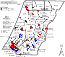
Cambria County is divided into 63 parishes, including a city , 32 boroughs and 30 townships . For statistical purposes, the US Census Bureau maintains eight census-designated places . These are part of a township and have no self-administration.
| Population development | |||
|---|---|---|---|
| Census | Residents | ± in% | |
| 1900 | 104,837 | - | |
| 1910 | 166.131 | 58.5% | |
| 1920 | 197,839 | 19.1% | |
| 1930 | 203.146 | 2.7% | |
| 1940 | 213,459 | 5.1% | |
| 1950 | 209,541 | -1.8% | |
| 1960 | 203.283 | -3% | |
| 1970 | 186,785 | -8.1% | |
| 1980 | 183.263 | -1.9% | |
| 1990 | 163.029 | -11% | |
| 2000 | 152,598 | -6.4% | |
| 1900-1990
2000 |
|||
Census-designated places (CDP)
1 partially in Blair County
Individual evidence
- ↑ Cambria County in the United States Geological Survey's Geographic Names Information System . Retrieved February 22, 2011
- ↑ Charles Curry Aiken, Joseph Nathan Kane: The American Counties: Origins of County Names, Dates of Creation, Area, and Population Data, 1950-2010 . 6th edition. Scarecrow Press, Lanham 2013, ISBN 978-0-8108-8762-6 , p. 41 .
- ↑ NRIS
- ↑ Listing of National Historic Landmarks by State: Pennsylvania . National Park Service , accessed July 18, 2018.
- ↑ Search mask database in the National Register Information System. National Park Service , accessed July 18, 2018.
- ↑ COUNTIES, COUNTY SEATS AND NUMBER OF MUNICIPALITIES IN PENNSYLVANIA - 2002 page 8 (English)
- ↑ Extract from Census.gov . Retrieved February 28, 2011
- ↑ Excerpt from factfinder.census.gov.Retrieved February 28, 2011
Web links
Coordinates: 40 ° 29 ′ N , 78 ° 43 ′ W

