
Neideck castle ruins
| Neideck castle ruins | ||
|---|---|---|
 Mountain spur of the Wiesent valley north-northeast of the Wartleitenberg with Neideck castle ruins from the west |
||
| Creation time : | Probably around 1050 | |
| Castle type : | Höhenburg, spur location | |
| Conservation status: | Restored ruin | |
| Standing position : | Ministeriale | |
| Construction: | Quarry stone masonry, partly with corner blocks | |
| Place: | Streitberg | |
| Geographical location | 49 ° 48 '31.5 " N , 11 ° 13' 56.1" E | |
| Height: | 402.9 m above sea level NN | |
|
||

The Neideck castle ruin is a former high medieval aristocratic castle above the village of Streitberg , part of Wiesenttal in the Upper Franconian district of Forchheim in Bavaria . Due to its exposed location high above the Wiesent valley , it has become a symbol of Franconian Switzerland .
The castle ruins are freely accessible, the residential tower serves as a lookout point .
Geographical location
The ruins of the Spornburg are located in the Franconian Switzerland-Veldenstein Forest Nature Park, about 800 meters east of the church in the village of Streitberg. It stands above the Wiesenttal on a spur ( 402.9 m above sea level ) north-northeast of the Wartleitenberg ( 488 m above sea level ).
You can reach the ruin on various hiking trails from the valley or from the villages on the plateau.
There were many other former castles in the vicinity of Neideck Castle: to the northwest the Streitberg ruins , to the north the Kulk castle stalls on the mountain called Guckhüll, to the east the Wöhr tower castle located on a former river island of the Wiesent near the hamlet of the same name. To the southeast, in the village of Trainmeusel , there was also a castle, from which a gable side can still be seen. In the immediate vicinity of the Neideck, about 250 meters south-west above, is the Wartleiten castle stables and an early medieval castle stables on the Hummerstein above Gasseldorf .
history
Prehistory and early history
The high plateau above the Wiesenttal served as a settlement area in prehistoric times. Archaeological traces of settlement from the Urnfield period , the late Hallstatt and early Latène periods , the early Roman imperial period and the period of the Great Migration Period have been documented. The unusual size of the medieval castle and the two extensive fortresses with their deep moats could indicate an early medieval rampart .
builder


The castle was first mentioned in 1312 as the property of the noble free von Schlüsselberg . A Heinrich von Neideck appeared in a written source as early as 1219. The castle was probably built in the 12th century, possibly as early as 1150/60. Back then, should be the core castle on the striking rock floor above the Wiesenttal only a small wooden Vorburg have stood.
Schluesselberger property
From 1312 it was owned by Konrad II von Schlüsselberg , the most important and last representative of his family. He expanded the Neideck into a fortress. With an area of 140 × 200 meters, it was one of the larger German castle complexes. Shield wall , outer and inner trench, two artillery towers, main trench with bridge, the residential tower and adjoining parts of the main castle can still be seen. When Konrad von Schlüsselberg was in feud with the bishops of Würzburg and Bamberg and the burgraves of Nuremberg in 1347 because of the construction of a toll , he was attacked and defeated by them. Konrad von Schlüsselberg was killed on September 14, 1347 by a stone bullet from a Blide and the castle was destroyed. After the siege , the Neideck became the official seat of the bishops of Bamberg.
Peasants' War and destruction in the Second Margrave War
After the castle survived the Peasants' War in 1525, it was captured and set on fire in the Second Margrave War in 1553 by the mercenaries of Margrave Albrecht Alcibiades of Brandenburg-Kulmbach . It has been in ruins ever since.
Until the early 19th century, the complex served the residents of the valley as a quarry. The decay was accelerated between 1737 and 1743 by the dismantling of the castle rock for marble extraction .
The increasing decay of the castle ruins prompted the community of Streitberg to carry out initial conservation measures shortly after the Second World War . In 1996, the Forchheim district began extensive renovation of the ruins, which was completed in 2008 with the opening of an archaeological park in the castle area. The work was accompanied by archaeological excavations, but not always carried out according to the latest methods of monument conservation .
description

.jpg)

The large castle complex consists of three sections separated by deep trenches . The outer outer bailey was already secured by a ditch about 100 meters long, 22 meters wide and about 7 meters deep. The high shield wall towering behind it was built around 1300. There are only minor traces of the foundations of the other buildings.
The inner bailey was reinforced in the early 16th century by two partially preserved artillery gondolas. The cross key notches of the eastern tower were designed for hook boxes and crossbows . The rectangular notches on the western roundabout were probably made around 1531/32. This bulwark flanked the entrance. The curtain wall between the roundels is almost completely gone with the gate of the inner outer bailey.
The main castle lies on a rock protruding to the northeast. The mighty residential tower rises three stories high. It was built after the castle was destroyed in 1347 on usable older foundations and walls. The former barrel vault on the first floor probably dates back to the early 13th century. Originally there was a fourth stone upper floor above the three floors that were preserved, possibly also a half-timbered structure . The mandatory high entrance has been retained on the first floor, the ground level entrance was only created in modern times. Since 2008, a staircase has made it possible to climb to the top of the wall, which is 10 meters high.
The remaining components of the core castle date largely from the time around 1480, when the fortress was expanded and reinforced after a siege . You can still see the barrel-vaulted cellar of a building and the shaft of a filter cistern . The historical entrance consisted of a late medieval gatehouse and a brick bridge over the deep ditch. There was a short drawbridge in front of the gatehouse .
The water supply is said to have come partly from the Trainmeuseler Brunnen located to the south , with which the castle was connected by a 1300 meter long pond line made of oak trunks. However, recent excavations in the main castle have shown that this thesis of the Nuremberg castle researcher Hellmut Kunstmann cannot be upheld. The alleged well was actually a filter cistern that was fed via wooden pipes from the roof surfaces of the immediately adjacent keep and other buildings.
Burgplatz is listed by the Bavarian State Office for Monument Preservation (Bodendenkmalpflege) as a hilltop settlement from the Urnfield period, the late Hallstatt and early Latène period, the early Roman Empire and the Migration Period under monument number D-4-6133-0110. The underground parts of the castle ruins from the Middle Ages and early modern times are also considered to be ground monuments .
The name of the castle is probably derived from its location on a low corner. Because of this very unfavorable position in terms of defense technology, a stone guard tower was built on the ridge above the facility. This tower was surrounded by a moat that can still be seen in the area. The site name Wartleiten (monument number D-4-6133-0153) reminds of the almost completely disappeared tower.
Historical illustrations

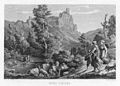
Neideck castle ruins, steel engraving (1834) by Conrad Wießner
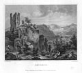
Neideck castle ruins, steel engraving (1840) by L. Beyer after a drawing by Ludwig Richter

Neideck castle ruins, lithograph (around 1840) by Theodor Rothbarth based on a drawing by Carl Käppel
Neideck castle ruins, steel engraving (1858)


_002.jpg)
literature
- Ursula Pfistermeister : Well-defended Franconia - Volume 3: Castles, fortified churches, city walls around Bamberg, Bayreuth and Coburg . Fachverlag Hans Carl GmbH, Nuremberg 2002, ISBN 3-418-00387-7 , pp. 94-95.
- Toni Eckert, Susanne Fischer, Renate Freitag, Rainer Hofmann, Walter Thousand Pounds: The Castles of Franconian Switzerland: A cultural guide . Gürtler Druck, Forchheim 1997, ISBN 3-9803276-5-5 , pp. 100-104.
- Gustav Voit, Brigitte Kaulich, Walter Rüfer: From the countryside in the mountains to Franconian Switzerland - a landscape is discovered . (Publication series of the Franconian Switzerland Association, Volume 8) Verlag Palm and Enke, Erlangen 1992, ISBN 3-7896-0511-5 , pp. 115–125.
- Gustav Voit, Walter Rüfer: A castle tour through Franconian Switzerland . Verlag Palm and Enke, Erlangen 1991, ISBN 3-7896-0064-4 , pp. 120-126.
- Hellmut Kunstmann : The castles of south-western Franconian Switzerland . Commission publisher Degener and Co., Neustadt an der Aisch 1990, pp. 37-58.
- Björn-Uwe Abels , Joachim Zeune , among others: Guide to archaeological monuments in Germany, Volume 20: Franconian Switzerland . Konrad Theiss Verlag GmbH and Co., Stuttgart 1990, ISBN 3-8062-0586-8 , pp. 243-245.
- Brigitte Kaulich, Gustav Voit, among others: Around the Neideck . Verlag Palm and Enke, Erlangen 1983, ISBN 3-7896-0057-1 , pp. 278-282.
Web links
- Homepage of the castle ruins Neideck Neideck.de
- Description of the Neideck castle ruins on the House of Bavarian History page
- Description of the castle ruins Neideck on the Foracheim.de page
- Castle ruin Neideck on the Burgenwelt.de page
- 360 ° panorama of the Neideck Panorama castle ruins
- Reconstruction drawing by Wolfgang Braun
Individual evidence
- ↑ a b map services ( memento of the original from December 19, 2012 in the Internet Archive ) Info: The archive link was inserted automatically and has not yet been checked. Please check the original and archive link according to the instructions and then remove this notice. of the BfN
- ↑ The Neideck castle ruin ( Memento of the original dated May 2, 2015 in the Internet Archive ) Info: The archive link was inserted automatically and has not yet been checked. Please check the original and archive link according to the instructions and then remove this notice. on the website of the Leader action group Kulturerlebnis Fränkische Schweiz e. V.
- ↑ Nina Günster: Of fountains, donkeys and other things: water supply on hilltop castles using the example of the karst region of the Northern Franconian Alb . Published by the European Castle Institute, 2013, ISBN 978-3-927558-37-3 , pp. 129-137.
- ↑ Bavarian State Office for Monument Preservation: Entry ( Memento of the original from July 26, 2014 in the Internet Archive ) Info: The archive link has been inserted automatically and has not yet been checked. Please check the original and archive link according to the instructions and then remove this notice.
- ↑ Bavarian State Office for Monument Preservation: Entry ( Memento of the original from March 4, 2016 in the Internet Archive ) Info: The archive link was inserted automatically and has not yet been checked. Please check the original and archive link according to the instructions and then remove this notice.

Castles: Ermreuth Castle | Graefenberg Castle (stone house, large house, Nuremberg nursing home) | Guttenburg Castle | Hagenbach Castle | Hallerndorf Castle (exited) | Heroldsbach Castle | New Castle (Hiltpoltstein) | Hundshaupten Castle | Jägersburg Castle | Kunreuth Castle | Pretzfeld Castle | Schellenberg Castle (exited) | Thurn Castle | Unterleinleiter Castle | Wiesenthau Castle | Wolfsberg Castle (Graefenberg) | Wüstenstein castle ruins
Castles and ruins: Bärnfels castle ruins | Bieberbach Castle (exited) | Dietrichstein Castle (exited) | Dietzhof Castle (exited) | Dörnhof Castle (exited) | Egloffstein Castle | Forchheim Castle | Gaillreuth Castle | Gößweinstein Castle | Graefenberg Castle (exited) | Hiltpoltstein Castle (Old Castle) | Kohlstein Castle | Moschendorf Castle (exited) | Neideck Castle ruins | Niederfellendorf Castle (exited) | Obertrubach Castle (exited) | Oberweilersbach Castle (exited) | Regensberg castle ruins | Reifenberg Castle (exited) | Reuth Castle (exited) | Rothenbühl Castle (exited) | Keystone Castle (exited) | Streitburg castle ruins | Thuisbrunn castle ruins | Unterleinleiter Castle | Vestenberg Castle (exited) | Wichsenstein Castle (exited) | Wolfsberg castle ruins | Wolkenstein castle ruins
Fortifications: Forchheim Fortress
Tower hill castles (all gone): Turmhügel Burk | Burgstall Ebermannstadt | Kersbach Tower Hill | Niedermirsberg tower hill | Tower Hill Rüssenbach | Tower hill Wöhr
Manor houses: Manor Dormitz (sold) | Steinhaus mansion (Dormitz) (sold) | Hammermühle Manor (sold) | Walkersbrunn manor (sold) | Wannbach manor
Castle stables (lost, unknown castles): Section fortification Altenburg | Section fortification Burggraf | Burgstall Alter Schlossberg | Burgstall Old Castle (Affalterthal) | Burgstall Old Castle (Oberzaunsbach) | Ringwall Old Castle (Drgendorf) | Section fortification Borschl | Burgstall Breitensten | Section fortification Burggraf | Burgstein Castle Stable (Peoplebach Castle?) | Ringwall Ehrenbürg | Burgstall Hainburg (Burgstall Rüsselbach, Burgstall on the cat) | Ringwall Heidelberg | Burgstall Heiliger Bühl | Burgstall Hetzelsdorf | Section fortification Hunnenburg | Section fortification Lehmberg | Burgstall Leutenbach | Ringwall Lindelberg | Burgstall Lindelburg | Section fortification Reisberg | Burgstall Retterner Pulpit | Burgstall Sattelmannsburg (Stadtmers Bürg) | Ringwall Schießberg | Burgstall Schlossberg (Haidhof) (Heidenstein) | Burgstall Thüngfelderstein (Eberhardstein Castle) | Section fortification Deep Storm | Burgstall Unterailsfeld | Burgstall Wartleiten
Fortified churches: Fortified Church Burk (Holy Three Kings) | Fortified Church Dormitz (Our Dear Lady) | Fortified church Ebermannstadt (St. Nikolaus) | Fortified church Effeltrich (St. Georg) | Fortified church Eggolsheim (St. Martin) | Kersbach fortified church (St. Johannes Baptist and St. Ottilie) | Fortified church Kirchrüsselbach (St. Jakobus) | Fortified church Langensendelbach (St. Peter and Paul) | Pautzfeld fortified church (Assumption of Mary) | Fortified church Pinzberg (St. Nikolaus) | Willersdorf fortified church (St. Bartholomäus)