
Franconian Switzerland


The Franconian Switzerland is a tourist region in Upper Franconia ( Bavaria ), which has received its own name through cultural and geological features. It is a characteristic mountain and hilly landscape with striking rock formations and caves as well as a high density of castles and ruins .
Geography and traffic
Franconian Switzerland is the northern part of the Franconian Alb . The area bounded by the rivers Main in the north, Regnitz in the west and Pegnitz in the east or by the federal highways 70 in the north, 9 in the east and 73 in the west is often referred to as Franconian Switzerland. The actual area of Franconian Switzerland, however, only includes the catchment area of the Wiesent .
The region extends over parts of the districts of Bamberg, Bayreuth and Forchheim. The most famous places include Pottenstein , Gößweinstein , Muggendorf , Ebermannstadt , Streitberg , Egloffstein and Waischenfeld .
Your limits are:
- in the north: Obermainland
- in the east: Bayreuth
- in the south: Erlangen
- in the west: Forchheim
- in the northwest: Bamberg
Information about Franconian Switzerland can be found z. B. in the Franconian Switzerland Museum in Tüchersfeld with its extensive regional collections. It is housed in the so-called Judenhof below two steep rock towers.
Franconian Switzerland tourism region
According to the current definition of the Bavarian State Office for Statistics , Franconian Switzerland comprises 68 communities in five districts, including all 29 communities in the Forchheim district :
|
Bamberg district eastern part |
Bayreuth district western part |
Forchheim district entire district |
District of Kulmbach south-western part |
Erlangen-Höchstadt district north and east of Erlangen |
|---|---|---|---|---|
|
Franconian Switzerland trade association
For business association Franconian Switzerland include 18 municipalities in two counties:
| Bayreuth district | Forchheim district |
|---|---|
Geology and formation

In the White Jura about 161 to 150 million years ago all of southern Germany lay in the area of a shallow sea. During this time, due to the constant subsidence of the crust, massive rock sequences were deposited on the sea floor. Franconian Switzerland is characterized by these limestone and dolomite rocks of the White Jura. It is a typical karst landscape with deeply carved river valleys and dry, barren plateaus. Many fossils are found in the layered limestones, especially ammonites .
The sea retreated due to uplifts of the European continental plate towards the end of the Upper Jurassic and larger areas became mainland at the beginning of the following Cretaceous period. During this time there was a tropical climate and intensive weathering of the limestone and dolomite rocks that had previously formed. In the Upper Cretaceous a sea penetrated again into the area of the Franconian Switzerland.
In the Tertiary , regional uplift resulted in a renewed sea decline and partial exposure of the Jura landscape.
History of tourism
Tourism in Franconian Switzerland began in Muggendorf at the beginning of the 19th century. Whey cures were offered in neighboring Streitberg . The tourist impulses came from the caves. Franconian Switzerland is one of the oldest holiday regions in Germany.
designation


The area used to be called "Muggendorfer Gebürg". The first travelers came during the Romantic era . The two students from Berlin, Ludwig Tieck and Wilhelm Heinrich Wackenroder , who studied law in Erlangen, are considered “discoverers” . They delighted their contemporaries with their report from 1793. The phrase “Franconian Switzerland” appears for the first time in the travel report My latest trip to water and land or a fragment from the story of my life (1807) by the Erlangen scholar Johann Christian Fick . Fick also uses the name in his historical-topographical-statistical description of Erlangen and its area (1812). It established itself as an independent landscape designation with the book Die kleine Schweiz (1820) by Jakob Reiselsberger from Waischenfeld or with Joseph Heller's book Muggendorf und seine Umgebung or Franconian Switzerland (1829). In the 19th century, Switzerland was a popular term for landscapes with mountains, valleys and rocks (e.g. Saxon Switzerland , Märkische Schweiz , Mecklenburg Switzerland or Holstein Switzerland ).
Soon distinguished spa guests made pilgrimages to Muggendorf to relax . Among the visitors were Karl Immermann and Richard Wagner . Even Ernst Moritz Arndt and Joseph Victor von Scheffel came across this land into raptures and called Franconian Switzerland as a "retreat of the German mind."
In the foreword to his travel guide, the Bamberg private scholar Dr. Joseph Heller:
- “One of the most charming and pleasant regions of Germany is certainly the one around Muggendorf, where fertile valleys in various directions with mountain ranges that are sometimes gently rising, sometimes suddenly rising to form a whole, rich in the most charming natural beauties, unite on a small area. This small stretch of earth rightly bears the name of Franconian Switzerland. What Switzerland offers on a large scale can be found here on a rejuvenated scale, and often more pleasant to the eye, in that one can oversee it and take it as a picture, instead of the tiny human being in some areas being unable to see the greatness of nature. and is, as it were, crushed by the enormous rock masses. "
- "Here the noble nature lets itself down more to the people, it smiles at him friendly soon in graceful mountain lines, mixed with lush deciduous and coniferous parts, soon it shows itself in its serious size in huge gray piles of rock. Lush meadows, fertile fields, picturesque villages half hidden under trees, crystal-clear mountain waters, fun and fresh swirling over and through rock debris, happy birds singing in the air, and who find coarse, intelligent, hard-working people who are still simple in their manners here the harmless traveler inviting to the joyful enjoyment of the present. "
Even then, Heller tried to delimit this area and suggested a six-hour walk from Muggendorf. Literally it says in his book:
- "The area around Muggendorf, which is not wrongly called the Franconian Switzerland, lies under the 28 ° 51 'east longitude of Ferro and under the 49 ° 48' north latitude and makes up almost a center of Germany."
With the expansion of the railway network, Franconian Switzerland became more and more accessible. There were railway lines from Bayreuth to Hollfeld, from Forchheim via Ebermannstadt to Behringersmühle and from Gasseldorf to Heiligenstadt.
At the beginning of the 20th century, the Franconian Switzerland Association took over the development. The association, founded in 1901, was inspired by the Wandervogel idea and took care of improving the traffic routes. In order to operate tourism professionally, this task was assigned to area committees as early as the 1930s.
Today the “Land of Castles, Caves and Mills” is marketed by the Franconian Switzerland Area Committee, to which the districts of Forchheim , Bayreuth , Kulmbach and Bamberg belong.
The area attracts many thousands of people looking for relaxation, hikers and nature lovers every year. Franconian Switzerland is very popular with motorcyclists due to its narrow and winding roads. On nice weekends there is a very high volume of traffic from motorists and motorcyclists. Probably the most popular and well-known meeting point for motorcyclists in Northern Bavaria is Kathi-Bräu in Heckenhof (near Aufseß ).
Features of Franconian Switzerland
mountains


Particularly striking are the witness mountains , which formed mainly on the edge of Franconian Switzerland, including the 539 m high Staffelberg in the northwest, the 587 m high Neubürg near Wohnsgehaig , the highest elevation in Franconian Switzerland at 627 m , the Kleine Kulm near Körbeldorf in East, as well as the honorary citizenship at Kirchehrenbach in the west . The Ehrenbürg is a double knoll with the 532 m high Rodenstein near Schlaifhausen and the 512 m high Walberla . The Walburgis chapel on the mountain is mentioned for the first time in a document from 1360 . She has given the honorary citizen its popular name Walberla . A fair is also mentioned in that document. The Walberlafest every first Sunday in May today attracts thousands of visitors.
Because of the rare plants, the Walberla was placed under nature protection. Archaeological finds testify to a settlement of the Walberla as early as around 1000 BC. Celtic fortifications (approx. 500 BC) are still recognizable today. From here you have a view of the Regnitz and Wiesent valleys. Bamberg Cathedral and the new buildings in Erlangen can still be seen in the background . The area around Walberla is characterized by the largest closed sweet cherry cultivation in Europe. The Walberla is also very popular with hang-gliders , even if they have to carry their kites up the mountain, as access by car is not permitted.
In addition to the Walberla, there are other very good vantage points in Franconian Switzerland. The most important are:

- The Leienfels castle ruins ( Pottenstein municipality ), 590 m
- The Spiegelfelsen and the Pfarrfelsen near Affalterthal , Markt Egloffstein , 468 m
- The Wichsenstein (municipality of Gößweinstein ), 587 m
- The Signalstein (to Wolfsberg, Obertrubach municipality ), 582 m
- The Hohenmirsberger Platte (near Pottenstein ), 614 m
- The Tannenberg (at the foot of which the Rote Main rises) near Creußen , 599 m
- The Graubühl near Creußen , 569 m
Climbing areas

See main article: Northern Franconian Jura Climbing Area
With over 6500 routes, Franconian Switzerland is one of the best-developed climbing areas in the world. This is where the first hook was cemented in, and this is where red point climbing had its roots. Due to the many perforated rocks and overhangs, Franconian Switzerland is one of the most important extra-alpine climbing areas.
The " Action Directe ", first climbed by Wolfgang Güllich , has long been considered the most difficult free climbing route in the world. However, this route is actually in the directly adjacent Hersbrucker Alb .
Due to the firm, grippy rock, you can already take routes of III. Climb vertically. Routes that climbers from all over the world make a pilgrimage to “Die Fränkische” are called Sautanz , Magnet , Stonelove , Wall Street , Action Directe …, all of which represent an era of the “ Red Dot Movement” that originated here and triggered a real climbing fever . In addition to Walberla and Röthelfels, important climbing areas are the Kleinziegenfelder Tal , the Trubachtal , the Wiesenttal , the Leinleitertal , the Püttlachtal , the Aufseßal and many other valleys.

Many of the rocks in the Northern Franconian Jura climbing area are designated as nature reserves or natural monuments , some of which are also part of FFH areas . There is also the Franconian Switzerland - Franconian Jura Nature Park . To protect nature from excessive exposure to climbers and to preserve sensitive ecosystems, a so-called zone regulation was drawn up between the DAV , IG Climbing , nature conservationists and the responsible authorities from 1993 onwards . This includes the classification of each individual rock (with larger rocks also individual sections) in a certain category:
- Zone 1: quiet zone, general climbing ban
- Zone 2: Climbing on existing routes is permitted, but opening up new routes is prohibited
- Zone 3: Climbing is generally permitted, including the development of new tours outside the vegetation zones
In addition, individual rocks are closed completely or for the breeding season (usually from early February to mid or late June) due to breeding birds, especially eagle owls and peregrine falcons , or particularly sensitive plants.
caves


Already in the 18th century the “old mountain” was searched for mysterious grottos. When the pastor Johann Friedrich Esper published a book about the underground labyrinths around Muggendorf in 1774 , the foundation stone for tourism was laid.
There are numerous caves in Franconian Switzerland, the most famous and largest of which is the Devil's Cave near Pottenstein . The region is a typical karst area with acid-soluble rocks such as limestone and dolomite . The penetration of carbonic acid formed countless caves, many of which are rich in stalactites. Dripstone caves developed for tourism are:
- the Bing cave near Streitberg (named after the Nuremberg toy manufacturer Ignaz Bing , who discovered the cave in 1905 ),
- the devil's cave near Pottenstein
- and the Sophienhöhle in Ailsbachtal , ( discovered in 1833 ; named after the daughter-in-law of the former owner, Count Franz Erwin von Schönborn -Wiesentheid).
Other caves are: Oswaldhöhle , Wundershöhle , Witzenhöhle and Doktorshöhle in the Hohlen Berg near Muggendorf , the Rosenmüllershöhle near Muggendorf, the Quackenschloss near Engelhardsberg (cave ruins), the Zoolithenhöhle near Burggorienreuth , the Esperhöhle in the Langenstein valley near Gößweinstein , the Schönstein Försterhöhle in the Zeubhöhle Valley that Klaus Church at Betz stone , the Riesenburg at Doo (collapse cave ) and Ludwig cavity in Ailsbachtal Valley. The Hasenlochhöhle near Pottenstein is known as a Stone Age cave . One of the deepest caves in Franconian Switzerland is the Fellner sinkhole near Gößweinstein with a depth of almost 100 m.
Waters

Franconian Switzerland is drained by the Wiesent water system and its tributaries Ailsbach , Aufseß , Kainach , Leinleiter , Püttlach and Trubach and is spatially bounded by the rivers Main , Regnitz and Pegnitz . Due to the geological and ecological conditions, the waters of Franconian Switzerland are almost exclusively native to brown trout , rainbow trout and grayling . This is due to the oxygen content, the water temperature and the food supply in the rivers. The ecosystem of the rivers in Franconian Switzerland is so intact that the fish reproduce naturally. In the course of land consolidation , however, many streams were straightened. The Wiesent is a popular hiking river for canoeists .
Castles
See also the list of castles and palaces in Franconian Switzerland
The Burgenstrasse , a tourist route with more than 70 castles, palaces and fortresses between Mannheim and Prague , leads through Franconian Switzerland . The following castles in Franconian Switzerland can be visited:
- Bärnfels castle ruins
- Egloffstein Castle
- Gößweinstein Castle
- Greifenstein Castle
- Hollenberg castle ruins
- Leienfels castle ruins
- Neideck castle ruins
- Neidenstein castle ruins
- Pottenstein Castle
- Rabeneck Castle
- Rabenstein Castle
- Stierberg castle ruins
- Streitberg castle ruins
- Unteraufseß Castle
- Waischenfeld Castle
- Wildenfels castle ruins
- Wolfsberg castle ruins

Egloffstein Castle

Gößweinstein Castle

Rabeneck Castle

Rabenstein Castle

Neideck ruin
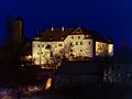
Unteraufseß Castle at night

Wiesentfels Castle
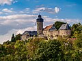
Zwernitz Castle


Churches

Until the end of the Holy Roman Empire , Franconian Switzerland belonged mainly to the Catholic monastery of Bamberg , while the northeast and the areas around Heiligenstadt and Streitberg belonged to the Principality of Bayreuth, which had been Protestant since the Reformation . Numerous field crosses can be found in the Catholic areas of Franconian Switzerland . Today there are 137 Catholic and Protestant churches in Franconian Switzerland. Almost every village has its church. A well-known place of pilgrimage is the Baroque Trinity Basilica to Gößweinstein . The sandstone building was planned by Balthasar Neumann and inaugurated in 1739.
The fortified churches are relics from uncertain times . The best known are the fortified church of St. Georg in Effeltrich , the church of St. Laurentius and Heinrich in Hohenpölz and St. Jakobus and Katharina in Königsfeld .
beer
_01.jpg)

In Franconian Switzerland there are still around 70 small and medium-sized breweries , most of which were founded in the 19th century as family-run businesses with their own bar. In Franconia , people like to speak of the "Franconian triumvirate" and mean that many breweries also had inns and agriculture. To this day, many companies only brew once or twice a week and only serve their beer in their own or in a few affiliated inns. Until the emergence of the craft beer movement , Franconian Switzerland was considered the region with the highest density of breweries in the world. In 2001 the small community of Aufseß , where four breweries in the districts of Unteraufseß, Heckenhof , Hochstahl and Sachsendorf have around 1,500 inhabitants, made an entry in the Guinness Book of Records . There are now beer trails all over Franconian Switzerland that connect the breweries with one another.
In contrast to many modern small breweries , the Franconian breweries mostly work traditionally according to the purity law . Typical beers of the region are the unpounded cellar or Zwickel beer and the mostly dark lager . The larger breweries usually also offer other popular varieties such as Helles , Märzen , Weizen and Pils .
regional customs
Easter fountain

The custom of decorating the village fountain at Easter originated around 1910, but after the Second World War the custom was no longer practiced in many localities, which is mainly due to the introduction of the aqueduct. In the early 1980s the custom was revived, so that in 1986 Easter fountains were decorated in 169 villages . Today, from Good Friday, over 200 villages decorate their village fountains with brightly painted Easter eggs . Blown eggs, which are painted or decorated, serve as decoration. In some places plastic eggs are used instead of real eggs, as the blown eggs are often destroyed by the weather or willfully. The main reason for this custom is to be found in the importance of water for the arid plateau of Franconian Switzerland.
- The Easter fountain in Bieberbach (Egloffstein) was included in the Guinness book as the "largest Easter fountain in the world".
- The Easter fountain in Heiligenstadt is also known . A farmers market is held there by the fountain.
Quotes
Ludwig Tieck wrote in the style of early romanticism:
“Behind Ebermannstadt you are still riding through an extremely romantic valley, through which the Wiesent meanders in many curves, on both sides quite high mountains, straight ahead also mountains in front of you; I haven't enjoyed such beautiful days as this one, it is an area that invites you to a thousand enthusiasm, a bit darkly melancholy and yet so extremely friendly O, nature is inexhaustible in beauty! "
Prince Pückler-Muskau wrote in 1834 in Muggendorf, the then tourist center:
“Franconia is like a magic cupboard, always new drawers open and show brightly colored, shiny jewels, and that has no end. If you want to enjoy Germany's most secret virgin charms, you have to travel to Franconia. "
The poet Johann Paul Friedrich Richter, known as Jean Paul , wrote about Franconian Switzerland in 1798:
"Here the path runs from one paradise through another."
In his travel guide about Bamberg and the surrounding area from around 1912, the author Dietrich Amende described the Bing Cave and quoted a poem by the poet Joseph Victor von Scheffel :
- “Burg Streitberg opens the row of castles on the rocky slopes of the romantic Wiesent valley. This is followed by Neideck, Gößweinstein, Rabeneck, Rabenstein, Wiesentfels (also easy to reach from Scheßlitz), Pottenstein, etc. When you see the castles rising up on the craggy stones, you hear Scheffel's verses ":
- Here you look into the country
- The stones and the franc.
- The turn thought it would be
- We took it from him as a winner:
- A rough stone on every mountain
- A warrior on every stone!
- "Mention should also be made of the idyllic water mills on the crystal clear streams and springs, such as Stempfermühle, Behringersmühle, Schottersmühle, Schüttersmühle etc."
- quoted from Dr. Dietrich Amende: Bamberg and Franconia. Bamberg undated (around 1912)
See also
- Places in Franconian Switzerland
- Regions with “Switzerland” in their name
- Franconian Switzerland-Veldenstein Forest Nature Park
literature
(in chronological order)
- August Sieghardt: Franconian Switzerland . Glock and Lutz, Nuremberg 1971, from the Deutsche Landeskunde library
- MERIAN monthly books , 6 / XXVI: Franconian Switzerland. 1973
- Friedrich Herrmann: Caves of the Franconian and Hersbrucker Switzerland. Regensburg 1980
- Brigitte Kaulich, Hermann Schaaf: Small guide to caves around Muggendorf. Nuremberg 1980, ISBN 3-922877-00-1
- Fritz Krause: Great Franconian Switzerland Guide . German hiking publisher Dr. Mair & Schnabel & Co, Stuttgart 1981, ISBN 3-8134-0135-9
- Erich Walter: Wild plants in Franconian Switzerland and in the Veldenstein Forest. Hof 1988
- Peter Poscharsky: The churches of Franconian Switzerland. Palm & Enke, Erlangen 1990, ISBN 3-7896-0095-4
- Rainer Hofmann u. a .: Guide to archaeological monuments in Germany, Franconian Switzerland . Theiss, Stuttgart 1990, ISBN 3-8062-0586-8
- Hans-Peter Siebenhaar, Michael Müller: Franconian Switzerland. Michael Müller, Erlangen 1991, ISBN 3-923278-15-2
- Gustav Voit, Brigitte Kaulich, Walter Rüfer: From the country in the mountains to Franconian Switzerland. A landscape is discovered. Palm & Enke, Erlangen 1992, ISBN 3-7896-0511-5
- Gustav Voit, Walter Rüfer: A castle tour through Franconian Switzerland. Palm & Enke, Erlangen 1993, ISBN 3-7896-0064-4
- Rolf KF Meyer, Hermann Schmidt-Kaler: Walks in the history of the earth (5). Through Franconian Switzerland. Dr. Friedrich Pfeil, Munich 1992, ISBN 3-923871-65-1
- Reinhard Feldrapp , Willi Feldrapp, Adolf Lang: Franconian Switzerland . H. Stürtz, Würzburg 1992, ISBN 3-8003-0210-1
- Toni Eckert, Susanne Fischer, Renate Freitag, Rainer Hofmann, Walter Thousand Pounds: The castles of Franconian Switzerland; A cultural guide. Area Committee Franconian Switzerland 1997, ISBN 3-9803276-5-5
- Stephan Lang: Höhlen in Franken - A hiking guide into the underworld of Franconian Switzerland. Hans Carl Verlag, Nuremberg 2000
- Hardy Schabdach: Underground Worlds - Caves of the Franconian and Hersbrucker Switzerland. Reinhold Lippert publishing house, Ebermannstadt 2000
- Thomas Hübner: 25 times Franconian Switzerland. Heinrichs-Verlag GmbH, Bamberg 2007, ISBN 978-3-89889-058-8
- The Fascination Caves leaflet is instructive and can be requested from the Franconian Switzerland Tourist Office together with other information material.
- Erich Döttl, Walter thousand pounds, Hans Weisel: highlights of Franconian Switzerland . Verlag Palm and Enke, Erlangen 2007, ISBN 978-3-7896-0677-9 .
- Franz X. Bogner: Franconian Switzerland. An aerial portrait. Aerial photo tape. Ellwanger, Bayreuth 2007, ISBN 978-3-925361-62-3 .
- Adolf Riechelmann: The orchids of Franconian Switzerland. Palm & Enke, Erlangen 2011, ISBN 978-3-7896-1701-0
- Reinhard Löwisch: 200 years of the region's name "Franconian Switzerland". u. a. In: Nordbayerischer Kurier , various editions, 2012 (online: loewisch.com PDF; 10.3 MB)
- Christof Herrmann, Helmut Herrmann: Beer garden hikes in Franconian Switzerland. Heinrichs-Verlag GmbH, Bamberg 2015, ISBN 978-3-89889-177-6
- Herbert Popp: Franconian Switzerland: Traditional tourist region in a karst landscape (Landscapes in Germany, Volume 81). Böhlau, Cologne 2019, ISBN 978-3-41251-535-5
Movie
- Picture book Germany : Franconian Switzerland. Documentation, 45 min., A film by Sigrid Esslinger, production: Bayerischer Rundfunk , first broadcast: June 18, 2006
Web links
- Frankenjura.com
- Franconian Switzerland Tourist Office
- Franconian Switzerland adventure region
- Homepage of the Franconian Switzerland Association V.
- Homepage of the Association of Franconian Switzerland Nature Park - Veldenstein Forest
- Franconian Switzerland Museum
- Nature experience Franconian Switzerland
- Historical views of Franconian Switzerland from the holdings of the Bamberg State Library