Wank stone
|
Wank stone
Gößweinstein market
Coordinates: 49 ° 44 ′ 15 ″ N , 11 ° 16 ′ 5 ″ E
|
|
|---|---|
| Height : | 548 (480-588) m |
| Incorporation : | May 1, 1978 |
| Postal code : | 91327 |
| Area code : | 09197 |
|
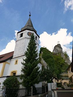
Wichsenstein: Church of St. Erhard and summit
|
|
Wichsenstein is a district of the municipality of Gößweinstein in the Upper Franconian district of Forchheim .
geography
Wichsenstein is located in Franconian Switzerland between the cities of Nuremberg , Forchheim and Bayreuth about six kilometers southwest of Gößweinstein and fourteen kilometers east of Forchheim. The Wichsensteiner Fels towering in the middle of the village can be climbed via a staircase and with a height of 587.8 m above sea level offers . NN a panoramic view of Franconian Switzerland.
history
The community of Wichsenstein was dissolved on May 1, 1978. The main part with then more than 500 inhabitants and the places Wichsenstein, Altenthal, Hardt, Sattelmannsburg and Ühleinshof was incorporated into the market Gößweinstein. The places Eberhardstein, Pfaffenloh and Urspring came to the Pretzfeld market with about 50 inhabitants at that time .
traffic
Wichsenstein can be reached via county roads .
The 222 bus connects the town with the large district town of Forchheim and the main town of Gößweinstein. Bus route 226 also travels there on school days. A collective call taxi operates in the evenings and on weekends .
See also
- Burgstall Wichsenstein on the Wichsensteiner Fels
literature
- Johann Kaspar Bundschuh : Wichsenstein . In: Geographical Statistical-Topographical Lexicon of Franconia . tape 6 : V-Z . Verlag der Stettinische Buchhandlung, Ulm 1804, DNB 790364328 , OCLC 833753116 , Sp. 214 ( digitized version ).
- Pleikard Joseph Stumpf : Wichsenstein . In: Bavaria: a geographical-statistical-historical handbook of the kingdom; for the Bavarian people . Second part. Munich 1853, p. 625 ( digitized version ).
Web links
Individual evidence
- ^ Federal Statistical Office (ed.): Historical municipality directory for the Federal Republic of Germany. Name, border and key number changes in municipalities, counties and administrative districts from May 27, 1970 to December 31, 1982 . W. Kohlhammer GmbH, Stuttgart / Mainz 1983, ISBN 3-17-003263-1 , p. 684 .

